November 4-6, 2017 Most Recent Posts:
Fort Clinch State Park Beyond Fort Clinch – Timucuan Ecological and Historical Preserve
Fernandina Beach, Florida The Beach at Fort Clinch
.
Clouds are again piled on the horizon. It’s nearly dark when I come out to see the colors. Dawn colors are as intense as they get usually. As the sun rises it seems to suck all the color into it.
But now, though it is dark, muted colors of the rainbow are starting to paint the sky in bands.

In just over 5 minutes, orange is streaking into the sky and the water is more visible.

Minutes later the gray skies in the North have a tint of pink and the full moon is beginning to set and cast a glimmer on the sand and water. Moonlight on the water – sounds as beautiful as it looks.

I walk on along the shore of the Cumberland Sound in the direction of the ocean.

The intense color is fading but the pinks are still strong in the east.

At the corner of St. Mary’s and Atlantic I find another morning of raging surf. Such power is a wonder to behold. Glad I’m not a sailor out on seas like this.

It looks like walls of water surging toward the shore.


Further down the ocean shore and way from “the corner, the waves are less angry.

The sunrise is nearly the same as it has been for the past couple of days with a bank of clouds at the horizon being lit from behind.

For me, this is the most beautiful time of the day even if cloudy or hazy.

As I look around, the sunrise has put a pink cast on the moon setting over the campground. You can just see a white rig on the right.

It’s almost an hour since I first came out and here comes the sun.

What a magnificient way to begin my day!


After breakfast we take a look at our map and see that there remain two spots in particular that we would like to visit before we leave Fort Clinch. The link in blue above is to the post on our previous stops in the preserve where we found a number of surprises.
We decide to go to the furthest away and work our way back just in case we have to leave something for next time.
So we travel back down A1A for 43 miles to see Fort Caroline, leaving Kingsley Plantation for later.
The ferry only runs sporatically so we take A1A past the road to Kinigsley and then Rt 105 down and around to Fort Caroline.. We can catch Kingsley on the way back..
Here there is another interesting visitor center with even more information on the Timucuan Indians.

Inside, before we even get to the exhibits, David talks with a man who was in charge of a just finished volksmarch on the grounds. I over hear another person asking the ranger about a bird walk which we find out is starting in just a few minutes. We decide to tag along and see.

From the visitor center the group heads across the lane to what is known as Spanish Pond.


I’m actually surprised that we see as many birds as we do in what is mid morning by now. Though hiding in the foliage, this Downy Woodpecker hangs around for quite some time and lets folks take pictures. He’s after the berries on the bush and we don’t deter him.

Apparently this tree behind our Audubon co-guide is a hangout spot for wood storks. Spanish Pond, quite over grown, is just off to her left.


The ranger points out the St. John’s wort lining the boardwalk.

Somehow I didn’t realize it was a bush.


Florida’s state butterfly is the Zebra Longwing who graciously posed for me.

We head back to the visitor center to see the exhibit about the Timucuan people.

It’s chocked full of information on their lifestyle, tools, everyday dress and crafts. I find it fascinating largely becasue of this book entitled L’Histoire Notable De La Floride by Rene de Laudonniere published in 1586. Most of what is known about Fort Caroline and the Timucuan of the area comes from this book.of Laudonniere’s personal account of the failed French colony. He was its founder and the book was published posthumously 21 years after he left La Caroline.

Most amazing .are the sketches by Jacques Le Moyne, one of the colonists. What a look into the past.


“They” meaning women apparently. Some of the hair makes me wonder.


I love the size of the alligator in this sketch. Is that possible? Or is it an ancestral way of selling books?


Not sure what I think about the accuracy of the details of the pictures but that this is “sort of” what he saw is the best we can hope for I suppose.
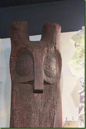
This owl totem dated as 1400-1500 is the largest wooden effigy ever recovered from an archeological site in North or South America. It is carved from a pine tree using tools of stone, shells and sharks teeth.
Iread it is believed that in Timucuan spirituality owls were messengers of the spirit of the night and guardians of the Shamans. Who knows these things?


I could have stayed longer and read more in the visitor center but we wanted to make sure we had time to see the outside exhibits and walk the trails.
The outside exhibits are recreations of a Timucuan Hut and of the fort. The original size and placement of the fort are still a mystery to historians. It is not a reconstruction of the original and serves only to bring the story alive of this short lived French presence in 16th century Florida.
A villager makes repairs to the hut.

Like the original, this replica Fort Caroline is located directly on the St. John’s river. Its design is taken from this engraving and is approximately 1/4 size.

Frankly, unless you are a serious student of history, there isn’t much to see. It’s very unlike other forts we’ve seen and left me with a lot of questions.

Nice partial mote but why? Was this really here? Was it a full mote at one time? A mote right by the river?


We could have walked the Le Moyne trail as shown in the map several pictures above, but we were more interested in hiking the more extensive trail section across the road. We wanted to see the shell mounds, the salt marsh and the Theodore Roosevelt area.
I do love the information and artifacts in and around the visitor centers but the beauty outside and the extremely short days (grrrr time change) make me impatient to get on the trail.
We walk back across the road and begin the trails at the Spanish Pond parking area. We retrace a part of our birding hike from the morning. Eventually we hike red to green where we turn left and follow it all along the water to the viewing platform marked with the binoculars picture. From there we take the dark trail to blue, turn left and take it all the way back around to the red trail skipping the portion of blue that leads to the second parking lot labeled Theodore Roosevelt Parking Area. We just ran out of time. As usual! Turns out to be about 4.6 miles by the time we’re finished.


We’d definitely begun to wonder where was this green trail when it finally showed up on the left. It leads along the water which we got glimpses of along the way.


So where are these shell mounds we’re saying to each other as we begin to climb.

HA! They’re under our feet. This entire forest is built on the Timucuan Shell Mounds. I’m shocked that we are allowed to walk on them.

As we go, the trails become more and more made of shells.

How long has this tree been growing on the shell mound?

We begin to see cut away areas where you can visibly experience the layering of the shells. These folks ate a lot of seafood over many years to create hills of shells this size.


We as come off the shell mound the salt marsh area is right in front of us. I was so taken with its stunning beauty that I never even took a picture of the viewing platform that allowed us fantastic views of the marsh and its inhabitants.

Nearly two thirds of the Timucuan Preserve is covered by salt marsh. It provides such a visual treat with its prairie-like expanses. Thank goodness for this 46,000 acre preserve which keeps ever encroaching development at bay. Still even with all this land the run off from developed edges is extremely harmful to the marsh and its creatures.

From the platform above the marsh we can see white spots in the grasses. Unfortunately David didn’t bring his binoculars. Unfortunate oversight!

But I can zoom in and see this great egret.

When he takes of for an assumedly better spot, we follow him with our eyes.

Now we see there are two birds.

I think the bird in the foreground is the Snowy Egret. At first, he didn’t look small enough to me but then I saw his yellow lores (between his eye and the upper beak). When he flies, I see his yellow feet.

His yellow feet are hard to see in this picture but I saw them in my lens at the time. Such fun that they are called his “golden slippers”.

The Great Egret takes off again making a wonderful picture above the muted grasses below.

The salt marsh is a real haven for wading birds. You can see why we spend a lot of time on the viewing stand. And no one else is here to see this Little Blue Heron.

This Tri-Colored Heron, see the stripe on his neck, is poised and ready to strike.

Finally we know we must head back. We’re not even half way along the trail and time is getting away from us. AGAIN.


On our way out of the marsh and toward the blue trail we watch a lovely mockingbird singing his heart out in a tree right beside the trail. On the other side, also just off the trail, are 3 or 4 Eastern bluebirds all in one tree. We stand and watch them all for quite a while taking the best pictures we can from underneath the tree against the too white, too bright sky. I am just amazed that the bluebirds simply sit there in trees right on the trail. I could nearly have reached out and touched them.
From the pictures they may have been parents and young ones though not so young.


When I see the picture of the cabin on the information board I wonder why the park service took it down rather than continue to repair it as a memorial to Willie Brown.

Instead, they’ve chosen to leave only wooden markers for the house’s foot print and door frame.

The blue trail circles us around where we pick up the red trail and retrace our steps to the parking lot.

By the time we reach the boardwalk it is nearly closing time for the area.

Here’s a look at an overview of the entire Fort Caroline National Memorial as it’s known. We’ve seen nearly all of it on our one day here but clearly one could return here many times.

Again, we don’t have time for Kingsley Plantation so it will have to wait for another trip. We spend our last day at Fort Clinch on the beach rather than making another drive down to see the plantation. There are many reasons to return to Fort Clinch but our visit is finished for now. Tomorrow we move on to Anastasia State Park in St. Augustine.

The visitor centre displays are fascinating. Those wild surf shots are incredible!
ReplyDeleteYour pictures of the surf were so amazing I could swear I smelled the salty air just looking at them. I miss living by the ocean and its many moods.
ReplyDeleteI sure do enjoy seeing the sunrise over the ocean. So much to see in a seemingly small area. Interesting sketch interpretations of the native lifestyle. Seems you still have reason to return.
ReplyDeleteAmazingly beautiful sunrise. The colors are striking. Love the raging waves. Your photos are fantastic.
ReplyDeleteThe Timucuan Preserve and Visitor Center look fantastic! I definitely want to go there. The owl totem is extraordinary. And your photos of the sunrise and surf are truly gorgeous. What a beautiful way to begin your day. You're inspiring me to get out earlier. :-)
ReplyDeleteI'm loving getting caught up (you've been busy!) with your November posts! Again, those waves and skies from the corner are powerful and beautiful. Those sketches of the natives definitely seem exaggerated, giving us not only a glimpse at their lives, but at how they were perceived by the European colonists :-) Love the hike over the shell mounds - that pic of David at the huge tree is perfect. Being a lover of wild grasses, the salt marsh really draws me in. I agree there are enough places named for Roosevelt that this one could have been better named for Brown. Eighty years - wow!!
ReplyDeleteGreat tour, going on the list:)
ReplyDeleteTook too long writing my comment and the page wouldn't load so it was lost :( Might be Kindle's fault. Enjoyed this blog! Jodee's comment echoes what I'd say about the sketches. Great sunrise pictures. Wonder what all that tree has seen...and the shells. The world is so difficult now. When we're that far in the past, what will the present be like?!?
ReplyDeleteLol...I meant the world is so "different" now...although, it's difficult in certain ways too for sure.
ReplyDeleteWow, that is a great post with lots in it! BTW, the hut roof may look thatched, however it is actually made from a plastic! I suppose it will last longer and require less maintenance expense. I think the artist skcetches of the natives are fanciful and reflect the eyes of the beholder/artist perhaps more than reality.
ReplyDeleteTook a moment to quick look up the Timucua. So sad they are an extinct people, can you imagine watching your whole culture disappear around you? It happened to the Beothuk in Newfoundland also, and to many other native tribes in North America unfortunately.
ReplyDelete