Tuesday September 9, 2014
South Rim Campground
Black Canyon of the Gunnison National Park
Montrose, Colorado
It rains all morning long so we don’t get out to finish the drive until the afternoon. We begin at MP 5.3, less than 1/2 mile from the Cedar Point Trail where we stopped yesterday. This is the official Painted Wall turnout. Having done the drive backwards, this wasn’t, as it should have been, the first of the turnouts featuring the Painted Wall. My recommendation is do them in order for the information’s sake.
Along the first part of the trail to the viewpoint we have a good view of the West Elk Mountains which are called laccoliths. They are now eroded into peaks, but once they were great domes of rock, pushed up like blisters by hot molten magma from far beneath. These volcanoes were the start of all of this beauty.
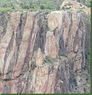
And then we come to the amazing Painted Wall. The darker rock is Black Canyon Gneiss. The bold white and pink bands are granites and pegmatites. No wonder I think the Painted Wall looks like granite. Pegmatites are extreme igneous rocks that form during the final stage of a magma’s crystallization. They are extreme because they contain exceptionally large crystals and they sometimes contain minerals that are rarely found in other types of rocks. To be called a “pegmatite,” a rock should be composed almost entirely of crystals that are at least one centimeter in diameter. Most pegmatites have a composition that is similar to granite with abundant quartz, feldspar and mica
Here in Black Canyon white mica, crystals of pink potassium feldspar and translucent quartz give the pegmatites their lustrous pink look
I am so taken with Black Canyon, one of the most dramatic canyons in the country. Deeper than it is wide in some places, this great slit in the Earth is so narrow that sunlight penetrates to the bottom only at midday. The park protects the deepest, most thrilling 14 miles of the gorge, about 75 miles upstream of the Gunnison's junction with the Colorado River.
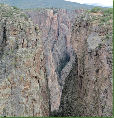
Our next stop is Chasm View only 1/10th mile from the Painted Wall. You can just walk over. This viewpoint is at a bend in the canyon where the walls close to only 1,100 feet apart. The steep walls of the Black Canyon range in depth from 2700 feet North of Warner Point to 1750 at the Narrows a short distance upstream from here. The Narrows, between Chasm View and Pulpit Rock, is the shallowest and the narrowest section in the monument. Here the canyon is less than 1/4 mile wide.
My attempts to get pictures down into this narrow spot are a dismal failure. You’ll just have to come see it for yourself.
Before the Gunnison River was dammed upstream for irrigation water and flood control, its water and sediment load gained tremendous momentum both above and within the Black Canyon. Today, the Gunnison drops over 4,600' along its 48-mile run through the Black Canyon — farther than the Mississippi falls over its entire 1,500 mile course. Along the 12-mile stretch within the National Park, the river's gradient averages a steep 96 feet per mile (about 2%) and tops out at 240 feet per mile at The Narrows.
The historical Gunnison flows reached a thundering 12,000 cubic feet per second at flood stage in the Black Canyon prior to damming. According to the park brochure, that represents 2.75 million horsepower of concentrated cutting power. By all accounts, Pleistocene floods were much greater. The violence of such events are beyond imagination
We move on to Devil’s Point at MP 4.2. A short trail leads out on a thin piece of land to the overlook. Reminders of fall are on the trail.
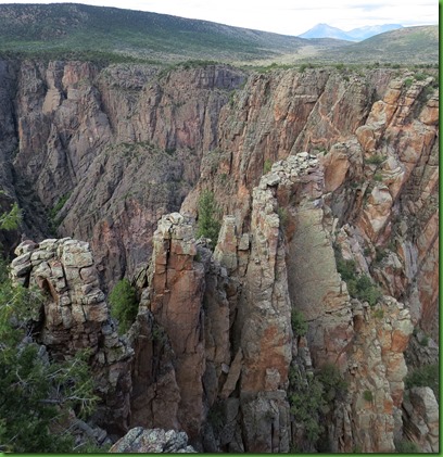
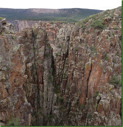
Some of the “trails” to the overlooks are in the hundreds or thousands of yards. Rock Point overlook is at MP 4.1. Cross Fissures is at MP 4.0 You can walk to them both from Devil’s Point. Remember what we are looking at is the North Rim. That will be important later.
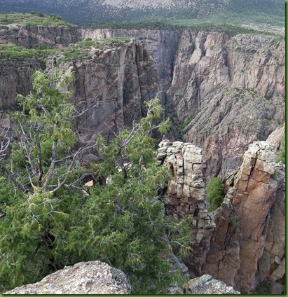
Every direction I turn looks different.
It’s all just amazing but if you speed through the overlooks may seem to be a lot the same. If you really stay a while, stand and take it in, you begin to notice the striking differences. The sections of the canyon are quite different.
These are the Cross Fissures, seriously different from the Painted Wall.
Our last stop before coming to the Visitor Center is Pulpit Rock. I didn’t read about any sermons being preached here but that’s sure what the name implies and the grandeur from this point would ensure a pretty impressive backdrop.
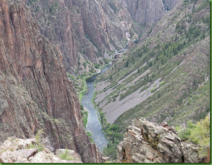
Swift water of the Gunnison River and abrasion from the sediment it carries are the chief cutting tools in the deepening of Black Canyon but there are other forces at work as well. Moisture entering joints and fractures freezes, thaws and as the fractures slowly widen, large rock masses are gradually weakened to the point where they slide or tumble to the canyon floor. What the river can’t carry away accumulates as piles of talus against the canyon walls or creates rapids in the river.
At this spot we can see that the South Rim has eroded back further than the North. The South rim faces north so it does not receive as much sun or dry out as quickly. A moist slope tends to erode faster than a dry one.
The carving process has been greatly slowed by the construction of the dams upstream. These dams hold back most of the sediment and most of the peak spring run off, both of which are necessary for the river to deepen its bed effectively and carry off material eroded from the canyon walls.
It took about 2 million years to shape the canyon as we see it today. I wonder if because of our dams we are now in the process of filling it back in. As you know, I think solar is our power answer not dams or oil or coal or other degrading methods. The creator must think us fools to be destroying this wonderland rather than putting all our time and research into using this huge fiery ball of energy. <stepping off soapbox>
From here I can get wonderful zoom shots of the misused river. I can see that there is not a way to walk along it and because of the dams it is difficult and perhaps even prohibitive to float/kayak it. The myriad of angles from this overlook are just fascinating.
There is one more stop on the drive and that’s Tomichi Point between the campground and the visitor center but we are going to do a loop hike through there tomorrow on our last day in this spectacular park.
The weather has been rainy and drippy all day long. You probably noticed us in our raincoats. Not bad weather for doing viewpoints and the big payoff for being out in this iffy-ness is the rainbow we see as we are leaving Pulpit Rock.
Note to self: That is a benefit to being on a tight schedule, I often go out when I might not if there were more days. I am usually rewarded when I do.
When we return to Winnona, guess who has come for dinner? We snap pictures of them from our doorway. Another great day!
![IMG_6344_thumb[2] IMG_6344_thumb[2]](https://blogger.googleusercontent.com/img/b/R29vZ2xl/AVvXsEiqFjbGiHzHJfhRD4tJ1N5r5qiA9_ZASjWPkzY8XasG-cOGN9Eg-hYlZP1v10vvqcfwUDFjizW2CAF-OyFpkujuKrRkdbVo9u-fogtCNiohmY67nSMYiktGTC-0Wwt5RCsN2L4YP_M_nT_b/?imgmax=800)









Isn't it amazing how every turn of the path, every mountain, valley, canyon has it's own unique personality.
ReplyDeleteYou have done a wonderful job sharing the Grand Canyon of the Gunnison. It is a place I only remember vaguely and have a photo of our 1952 Buick on the bridge when I was 9 or something. Thanks so much, Sherry, I might never have thought I needed to see it if it weren't for reading your blog
ReplyDeleteAwesome photos.
ReplyDeleteWhat a spectacular canyon! You have wonderful pictures and give a great tour for those who haven't been here yet.
ReplyDeleteI loved the graphic at one of the overlooks depicting the canyon walls in perspective with the Empire State Building. Made a huge impression on me!
ReplyDeleteSuch a magnificent canyon!
ReplyDeleteYou are so right that the view is so different in every direction you look. How beautiful it all is.
ReplyDeleteI had never even heard of the Black Canyon. Thanks for the tour. It looks like another must see place.
ReplyDeleteWhat an amazing place! We WILL get there, one of these days. So glad the trip is going well for you and hope David is doing well. I must assume you're back by now and hope you will share news when you have it. Think of you both often. Hope to see you this winter in Florida!
ReplyDeleteSo glad that you went there, and are so nice to share it with us. It is because of your blogs we have gone to many places so far in our journey. Lovely rainbow!
ReplyDeleteA beautiful rainbow and two furry friends to greet you at the end of your hike -- perfect!
ReplyDeleteEven on a rainy day the views are wonderful. Another beautiful spot has been added to our TODOS list:o))
ReplyDeleteSo informative! And a nice tribute to a beautiful canyon and river with its many curves. How wonderful to see a rainbow - nature's reward even in the rain!
ReplyDeleteso many glorious places. . .one as beautiful as the next!
ReplyDeleteI wonder at how moved I am by this place.......the photos evoke such a strong emotional response. In a good way of course :-) Maybe it's the depth, or the incredible variety of beauty in the geology; whatever it is I know this is a place I will have to visit. Soon! Here and the plains of Nebraska (not somewhere remotely on any list prior to your posts from the area) are high priorities now :-) Although a month ago now, I imagine you are enjoying returning here through your writing and photos.
ReplyDeleteYour posts on this have been wonderful. Gunnison is on the list for our next visit to Colorado.
ReplyDeleteYou've sold me! Gunnison canyon is now officially on our "Must See" list! ;c)
ReplyDeleteSuch a striking landscape -- you do a great job of conveying the magnificence in your photos. I agree with you that it takes time to really "see" -- that seems true of all of life. Wherever you are, you seem to immerse yourselves in the beauty.
ReplyDeleteRain or shine … Colorado is splendiferous … gorgeous photos, Sherry… you always do a great job of taking us along on your hikes … WOW
ReplyDeleteI really wish I can grab hubby to follow your footsteps. The grandeur of all the places you have shared with us is just overwhelming. Our list is getting longer!
ReplyDeleteWow! Spectacular is a very light word to describe what you just shared. I have to convince Steve to include this on our list. Thank you.
ReplyDeleteWow! Spectacular is a very light word to describe what you just shared. I have to convince Steve to include this on our list. Thank you.
ReplyDelete