Saturday September 21, 2014
Mammoth Cave National Park Campground
Mammoth Cave, Kentucky
First just a note about yesterday.
")
Yesterday’s post was about our Gothic Avenue Tour. We actually did two tours that day but the post was long enough just talking about the one.
At 5:00 we took the lantern light Star Chamber Tour. I was really looking forward to this one and it turned out to be a serious disappointment, not because of the cave but for the first time ever in my life we had a really irritating Ranger Guide. I know Gaelyn is going to hate to hear this.
At the risk of offending, the only word for him is “smart ass”. He was rude and snippy throughout. If this was supposed to be funny or entertaining it sure wasn’t. His answers to questions were so curt and cutting that people stopped asking which I guess was the point. He was snapping at anyone who even had a small red light sensor camera such as mine. That’s how I can take pictures in the cave, my camera has a little red pin dot of a light meter that determines how dark it is. After he yelled at me once I didn’t take another picture even though I knew that unless he was looking right at me he would never see the tiny red pin light.
Charlie enforcement of the “no flash” rule was not restricted to flash but meant any light at all no matter how small. Thus no pictures except this one of his lordship taken before we went in. I wish we had had time to take this tour with a different guide, the tour itself went through wonderful areas of the cave. But our days here are numbered and already full of tours.
I strongly suggest that if you take any tours here that you ask at the counter when you buy or pick up your ticket who is guiding or better yet the names of all the rangers assigned to this tour and think better of any that have Charlie as part of the group. Swap your tours and times around to avoid him. You’ll thank me. I am writing a comment about him and his attitude suggesting that it is long past time for him to retire from this job with the public that he clearly does not like. If this were the only tour I’d taken, I would have a very negative opinion of the park.
On to today. Time to take a hike outside this time.
I got up this morning with the sunrise but since the campground is in a nearly totally wooded area, there wasn’t much to see. David was sleeping in so I got dressed, took some water and headed out to see about the trails in the park.
Everything is wonderfully accessible from the campground so until we have exhausted everything here, there is no need to go further afield.
Today I walked over to the campfire circle and past it on the Whites Cave Trail, colored yellow.

It’s a lovely morning on a lovely trail. As you would expect on land above a cave, the ground has many rocks beneath the greenery and quite a few to big to be covered up.
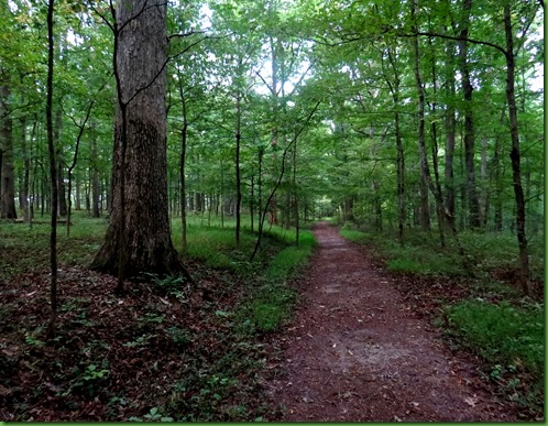


There are patches of wildflowers along the trail and short spurs that lead to benches which would be wonderful for just sitting for a while to enjoy the scenery and the silence.

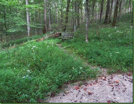

About a mile down the trail I find the Echo River Spring and a spur trail that will take me to the Green River Ferry. I’m very familiar with the Florida Springs and it is surprising to me to see the same blue water here in a depression off the trail.
Springs are often thought of as the beginnings of rivers but this spring actually marks the end of subterranean streams that have traveled unseen for miles. Starting with rainfall draining into sinkholes, underground rivers like the Hawkins River, the River Styx and here the Echo River emerge to flow into the Green River.
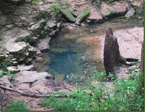
These submerged passages at one time lay above the level of the Green River but geological processes have caused the river to cease downcutting for a time and to rise in its bed, burying the cave openings in sediment. As the waters emerge through the sand and mud, these outlets become known as alluvial springs. An alluvial spring with no outlet is sometimes known as a “Blue Hole”.
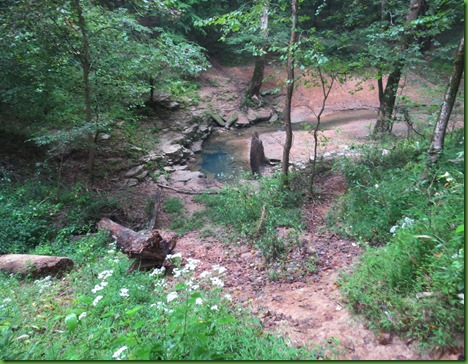
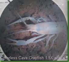
Thus the Echo River runs through the deepest area of the cave and comes out of the ground here to join the Green River. In 1991 we were one of the last groups to be able to take a boat trip on the Echo River to see some of the aquatic animals like the colorless crayfish and the eyeless cave fish who live all their lives in the dark. Also here in the dark is the endangered Kentucky Cave Shrimp found no where else in the world but in Mammoth Cave. Adapted to a world with little food, few predators and no light, these secretive creatures are vulnerable to changes in their habitat, such as any form of pollution or backfloods from the Green River. Shortly after we were there with Carrie and Kate, the river boats were discontinued as too stressful for the habitat.


The trail passes around the spring so that you can see if from both sides.

Further along the trail toward the ferry I come to more information about the spring and a blue hole, which does not have an outlet.

The path goes only a little further before coming to a parking lot above the Green River Ferry.


I just LOVE that there is a ferry here and not a bridge. I don’t know how the state or the county afford it since it is free but I’m sure glad they do. The Green River and Houchens Ferries which cross the Green River are two of the few operating ferries in the country. There was one at Hatton on the James River just south of Scottsville. I’m not sure it is still running. But I hope so.
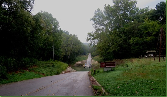
Before the establishment of Mammoth Cave National Park, about 45% of park lands were cultivated or grazed. Primitive wagon roads connected farmlands as did a fleet of river ferries. Buffalo, Dennison, Demunbrun, Sanders, Turnhole, Fishtrap, Mammoth Cave and Houchins ferries provided a way across this major river barrier. The old ferries were large enough to carry a wagon and team, and often shipped crops and other goods.

I’m looking down the river and thinking what a great kayaking river it would be when I see the wild turkey on the road side.
He turns and starts out into the road to cross when a car comes up to take the ferry. He moves back up on the hillside.


While that car is going across another lucky car on the opposite side comes down and doesn’t have to wait but just drives on board after car A disembarks. The turkey moves out into the road. I’m thinking he’s going to get caught in the middle of the road when the dark car comes up the this side.


He hears the car and goes back again to the side he was on. But once that car leaves he makes a more hurried move to the opposite side and after he has made it safely I go back down the trail toward Echo River spring.

I pass the spring again and return to the main trail turning left onto the Echo River Spring Trail colored purple on the map.


My peripheral vision catches something and I stop to see. Can you make it out in that circle of black? Really well hidden in all the understory. As we stare at each other, I zoom in for a picture.


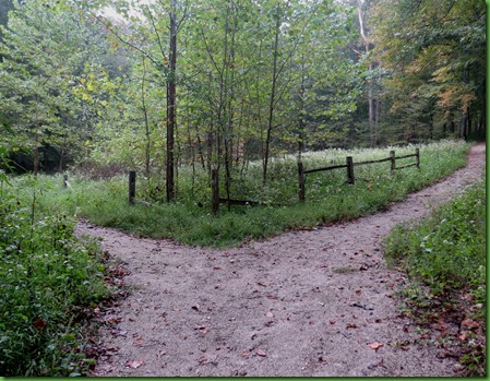
I come to a choice. It doesn’t look like this on the map but the left hand fork is the Echo River spring Trail. I’m not sure what the right one is. Looks like a short cut up to the Dome Sink Trail.

I had intended to go up and see the River Styx Spring but it is now about 8:45. I spent quite a bit of time there at the ferry so I decide to leave the upper section of the map for another day. I turn right.
Not very far up the trail I see this building off to my left. An information board tells me this is the CCC Chlorination House.
This is a recurring story in state and federal parks throughout the country. We owe much of their beginnings to the Civilian Conservation Corps. I’ve waxed philosophic on this FDR idea which I think bears repeating so I would go through it again.
Between 1933 and 1944 thousands of young men were encamped at the newly authorized Mammoth Cave National park in four CCC camps. They built roads, trails, controlled erosion, installed telephone and water lines AND installed the first formal system for treating waste water.

This small building known as the chlorinating house was part of what was then a state-of-the-art sewage treatment facility. The facility’s small size and location within the Green River 100 Year Flood Plain left it obsolete and abandoned by 1995. This means it might have been being used when we were here in 1991. Today all waste water is pumped out of the park through a region sewer system.

At the intersection of whatever trail I am now on and the Dome Sink Trail, I find that I am right at the spur off to the Mammoth Dome Sink. Well all righty, I have time to go there and take a look.


It’s a sinkhole all right and not a very big one. But the information board tells me that sinkholes are found by the TENS of THOUSANDS in south central Kentucky. Wow! Sounds like Florida. But here they are each performing the same task, funneling water from the surface to the underground.
This sinkhole along the side of the sandstone-capped ridges of Mammoth Cave acts like a natural downspout. Water runs off the ridge tops until captured by the sink. Often these sinks allow water a direct vertical path to the easily dissolvable limestone below. As more water continues to drain, it creates more open vertical shafts within the cave system. Mammoth Dome Sink’s natural funnel has created one of the cave’s most Mammoth shafts. Mammoth Dome drops 192 feet from top to bottom.
It sure doesn’t look that spectacular up here. I’ve seen much bigger sink holes but I’d sure like to see that 192 foot shaft below ground. And I think I’m going to get to do just that on our last cave tour here. Very cool!

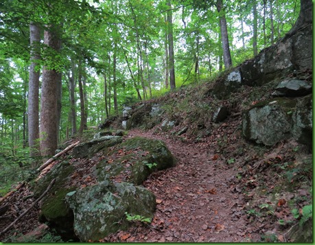
It’s a climb straight up on the Dome Sink Trail to the Heritage Trail at the top on the level with the Visitor Center. It’s in blue on the map. The main reason I’m interested in it is to visit the Old Guide’s Cemetery.
I come up these stairs on the top and take the circular trail all the way around before going down the center path. The trail has a nice westward view for sunset, several benches are placed around it as well as informational panels about the history of the park.

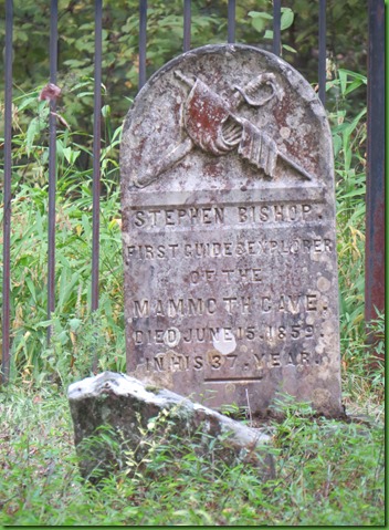
I take the spur down the middle and see the grave of Stephen Bishop in the back on the right by the brick whatever it is. I’ve come to pay my respects to a man I’ve heard about on every tour that goes in through the Historic Entrance. But for those who don’t know, there are several information stands along the edge of the cemetery. Along with information on the generations of African Americans who worked as guides here.

In 1838, African Slaves Stephen Bishop, Matt Bransford and Nicholas Brandford came to Mammoth Cave to work as cave guides. Dr. John Croghan purchased the Mammoth Cave Estate and the guides including Bishop in 1839.
Stephen Bishop was undoubtedly one of the greatest explorers Mammoth Cave has ever known. He was in his late teens when he was brought to Mammoth Cave in 1838. He ventured beyond the toured areas and in his spare time discovered many miles of the Mammoth Cave no one had ever seen. The gateway for modern exploration of the cave is attributed to Stephen's crossing of a deep vertical shaft known as the Bottomless Pit. The areas he discovered beyond the Bottomless Pit can still be viewed by visitors today, places such as Fat Man's Misery, Cleveland Avenue and Mammoth Dome.
Stephen was described as a showman and visitors wrote of his speech and singing voice.
In 1842 he was asked to draw a map of the cave system from memory which he did in great detail. Amazingly Bishop was given credit for the map when it was published in 1844. The map showed 10 miles of passages and was in use for 40 years.
Stephen Bishop died in June of 1859, 3 years after being granted his freedom in Dr. Croghan’s will. His grave stone, donated by a cave visitor 20 years after his death, was originally created for a Union Soldier whose family did not come to claim it. So the name was removed and Bishop’s put on there. Thus the design which has nothing to do with him.
The inscription reads First Guide & Explorer of the Mammoth Cave Died June 15, 1859 in his 37, year.
After visiting the grave, I walk back to Winnona and pass what I am sure is one of the cottages that my family rented in the 1950’s when I first visited here. They are sitting in a circle facing the woods and are in the process of being newly painted. I would for sure have rented one just to see what they are like now if we didn’t have Winnona.

Further along on the walk back to the campground I pass the large Amphitheater used during the summer. To my right, after crossing the bridge, I see the smaller campfire circle used in the spring and fall. I passed it at the beginning of my walk early this morning. I’ve done about 5 miles in 3 hours which is a pretty quick pace for me.


It was great to see what is above ground in this 53,000 acre park. We have another Cave Tour scheduled for this afternoon unless we find that Charlie is the guide. If we do, I will ask for a refund.


")


