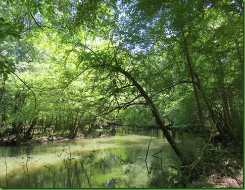
Go confidently in the direction of your dreams. Live the life you have imagined.

Henry David Thoreau

Need Your Help and Advice

Sunday April 26, 2015
Charlottesville Virginia


clip_image002

I don’t actually remember when google came out with their “new” maps but after trying it out for a couple of hours on real life trips and hating it, I’ve been doing all the clicks to go back to classic maps for months.  All was well, I could do everything I need easily.

Of course they kept saying “some day” you’ll have to change but they never said exactly when that would be.  Well apparently it has happened in the last day or two.  At least Microsoft gives you a date after which you are toast.  But if google did, I sure didn’t see it.

Anyway, now that Google maps has done away with their classic maps, or at least I can’t make them send me back there, I find that I was right originally.  I absolutely hate the new google maps so I need your advice on what you use for mapping your routes.  I’d love to have a lot of experiences and perhaps a discussion on this in the comments.  I’m using a PC so if you are a MAC person, will I be able to do what you do?

How do you find your campgrounds and plan your routes?
What are you using to map your routes?
Is there a really good GPS especially for RVs that won’t take you down roads or under bridges that you can’t go handle in a Class A?

Not being a GPS lover, I have used google maps exclusively for years as our source for travel routes.  I can drill down and see the road if I need to. I want to see where I’m going rather than have someone I can’t talk to telling me where to turn.   I could be talked into GPS by some really enthusiastic recommendations especially if there is a GPS that will route for RVers.  But for sure I’d love some sort of mapping program specifically for RVs.

If you know of one, please let me know. I just can’t make the new google maps as flexible and informative as the classic maps.

Why do they do this? Do these people ever actually use their products in real situations? Or is it all about how cool it is and how clever they are? 


My new motto

clip_image001


I’ll get back to what we’ve been up to lately and the beauty of Spring in my next post after every one has weighed in on their advice.  Perhaps we can all learn from each other.  That would sure be fun.

Thanks in advance for all your help!   I LOVE my commenters!!

Leaving Florida Headed North

Friday April 9 to Tuesday April 14, 2015
Florida Caverns State Park, Marianna Florida to Charlottesville, Virginia


FRIDAY April 9

Today is our last day at Florida Caverns. We spend it relaxing around the rig and swimming in the spring.  Later in the day we start the take down.  We clean off the mats, fold them up and put them in the bin. Put away the chairs, the table cloth and bench cushions, put up the awning, put the bikes on the car, cover them and check all the vehicles fluids just to name a few chores completed before heading out for the long drive north.


SATURDAY April 10

We hustle to get a fairly early start this morning on our uncustomarily long 265 mile drive into Eastern Georgia.  We’re pretty far west in Florida so we have to take I 10 all the way over to Jacksonville to pick up I-95 heading north.  We also lose an hour here by coming back into the Eastern Time zone from Central.  I will never understand why we keep springing forward and falling back or why in the world some states are split by time zones. 

Being in a hurry is never a good thing for me and today is no exception.  We are on the road about an hour when I get a phone call from the park saying I’ve left all my coach keys along with the dolly lock on the picnic table.  SIGH………..   they say they will send them to me.  How very nice of Florida State Parks to absorb the mailing cost for my carelessness.  And thank goodness, there are about 8 keys on there to the bike locks, the dolly lock, the bins, the coach and I don’t even remember what else.

We arrive late afternoon to the totally full Walkabout RV Park in Woodbine Georgia.  When I found this park our first year on the road, there were maybe 10 rigs here.  We always just stopped here coming and going from Florida.  Drive in and park.  No more.  Thank goodness we have a reservation.  The number of people using his park and RVing in general has skyrocketed in five years at least in the east.  It takes some of the fun out of it for me to have to keep to a specific schedule.


IMG_3871


SUNDAY April 11

Nothing to report here but long days of driving.  After 188 miles on Sunday we are in South Carolina where again we luckily have a reservation as the sign on the door says “full” when I walk into the office. This too was a place we never made reservations before.

The highlight of this stay is these darling electric cars.  The yellow one is used to lead you to your campsite here at Jolly Acres RV Park.


This second one is for sale and can be your toad for $10,500.  It’s even shaped sort of like a toad I think although the yellow one would be better.  Actually a green one would be best.  What a hoot!!

IMG_3874


IMG_3876

MONDAY April 12

Monday night we are not so lucky.  We usually stay at Carolina Crossroads in Roanoke Rapids, North Carolina and have never found it to be more than half full including this fall.  If you make a reservation you can’t use any of their discounts like Passport America or Good Sam. So I never have made one.  But when we pull in here in the late afternoon after a long day, they are totally full.  I have never seen this park like this.   After a PDD day for us of 300 miles, we are tired and in no mood for this.  So we park ourselves in a large parking lot nearby and hope for the best.  Free boondocking right off of I-95.  Now that’s amazing if it works.


TUESDAY April 13

Well nobody knocked on our door in the middle of the night. but it becomes pretty clear that fate isn’t any more interested in our returning to Virginia than I am.  We are up and out of the giant parking lot at 7am.  This is way early for us but we have nothing to do but bring up the jacks and bring in the slides. We stop at the Virginia Welcome Center for their restrooms and to have some breakfast. Finally the long time Virginia slogan “Virginia is for Lovers” is actually true for all lovers as Virginia’s marriage restrictions were struck down by the Supreme court in October of 2014.

Things seem to be going along fine on this last leg of our trip.  However, boondocking the final night before returning to Charlottesville is a problem since we were not able to empty our tanks and now have to find somewhere to do that.

I check on line about finding a dump site.  RV Dumpstations has mostly campgrounds that will allow you to pay.  That’s fine, but nothing near us.  My droid Pilot App says that there is an RV Dumpstation at a Pilot 11 miles ahead of us.  Perfect!  We can get gas and dump.  

Well sort of.  We get there and there is no gas, only diesel.  The entire area looks like a road construction zone with all the pot holes.  SERIOUS potholes that a child could fall in and never be seen again.  We find the dump station in all the mess and it is on a side ways slope.  WHAT?   Are they nuts? 

OK so we weave around in and out of the 18 wheelers parked everywhere and manage to get back to the dump station tilting in the right direction.  That accomplished, we drive 7 miles back to get gas at the Flying J we passed earlier in favor of trying to accomplish two things at the same time.  I’ve investigated our gasoline fill up possibilities and there is nothing easy once we get near Richmond and on to Charlottesville.  So back we go.   Two steps forward, one step back.


Despite our early departure it is 9:30 when we are finally on the road north and we’ve gone less than 15 miles.  

To add to the fun, it rains most of the way.  We take I-95 to I-288 around the west side of Richmond and then are on our last leg, I-64 to Charlottesville. 

It’s still raining when we arrive.  We unload overnight gear and save whatever else we may need for a hopefully dry tomorrow.   In Ruby, we drive out to the farm to check out the road.  The rains here have been so terrible that the farm road, particularly the beginning and a low spot just beyond the woods, is the worst I’ve ever seen it.  Another problem to deal with. 

But for now, Winnona is parked in Charlottesville on a nice paved street until we can come up with a better answer.   She’s in a pretty scenic spot with the gorgeous pink dogwood.

Touring the Cave

Thursday April 9, 2015
Florida Caverns State Park
Marianna, Florida


So today is the day we finally will see these Caverns for which the park is named.  We bike over and arrive at 20 minutes until 9.  The ticket office opens at 8:45 we were told.

But when we arrive, the office is open, people already have tickets for the 9:00 tour and we are told that the next available tour is at 10:30.  WHAT?  The tours run every half an hour.  So already the first 3 are completely full?  On Monday there were about 8 people for the 9:00 tour.  Boy did we miss our chance to be part of a small tour by going to see the VC first.  Oh well. 

They tell us that there are two school groups and that they are allowed to sign up 3 weeks in advance and take up an entire tour slot.  No one mentioned this on Monday.  We sign up for the tour and rather than bike back 5 miles back to Winnona and then back here again, we walk the Beech/Magnolia trail again.  Nothing new to report there but it is a lovely way to pass the time.


Looks like since they are closed Tuesday and Wednesday, the very best bet for a not full tour is Monday at 9:00.  Tours are limited to 25.  Well sort of.  They don’t seem to keep very good records and when our guide starts collecting tickets it seems they have sold 28.  She tries not to show that she’s a bit irritated at that.

She tells us a little about the history of the caverns where both human and bear bones have been found.

As the Civil War raged, Confederates explored the caves as a possible source of nitre for making gunpowder as was done in Mammoth Cave in Kentucky , but found them too wet.

In the 20th Century, Dr. J.C. Patterson of nearby Malone visited Virginia's Luray Caverns and immediately realized the potential of the caves. He bought 494 acres at the site in 1935 and led a civic drive that called for the formation of today's state park. Dr. Patterson's dream was realized and the Civilian Conservation Corps (C.C.C.) soon started work building many of the facilities seen at the park today. These workers not only built roads, trails and buildings, they discovered the main cavern now used as the tour cave.

We walk over to the entrance, she opens the door and down we go.

IMG_3702


On the ceiling just inside the door is an eastern pipistrelle bat, the most common one in these caves.


IMG_3706


The ranger has a flashlight that she uses to point out specific things as she explains the formations.    She turns the cave lights on in each section when we arrive and off when we leave so that the cave creatures can continue in the dark habitat which they need and so that algae won’t grow on the formations.  But with cave tours every half hour 5 days a week, I wonder how well this works.


IMG_3723


Florida Caverns State Park came into the Florida Park System in 1935. The CCC and WPA constructed the park facilities and roadways. The original entrance to the cave was actually discovered by accident. In March of 1937 a government surveyor, Oliver Chalifeaux, found a tree that had fallen over during a storm had exposed a new cavern. The roots took up the earth with the tree and left a hole in the ground. When he crawled into hole he discovered the beautiful formations that we see today.

After this discovery, the CCC began the excavation and development of the tour cave. Their work continued until 1942. The tour part of the cave, covering an area of nearly 2 acres under the park, has been open for public enjoyment since that year.

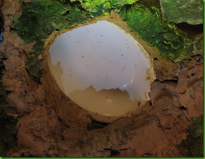
The lights in the cave were originally put in by the CCC.  They were not very bright so the men cleverly mounted their dinner plates above the fixtures to create brighter light.  Some of the plates are still there over 70 years later.  The more modern lights are brighter and you can see the algae around them.

IMG_3729


This is the back of the plate in the ceiling.  The brown stains around the edges have accumulated over the years.
IMG_3730


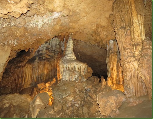
The cave has dazzling formations of limestone stalactites, stalagmites, soda straws, flowstones, and draperies.

This formation is a flowstone known as the wedding cake.  Many people have gotten married here over years and the ranger says they still have several weddings a year.
 

IMG_3713


IMG_3716


  There are ribbon and soda straw formations.


IMG_3719


There are glassy lakes.

IMG_3734


Even the floor is lovely.


The colors of the flowstone formations are quite varied.


IMG_3747


Stalactites and columns

IMG_3748


IMG_3749


IMG_3750


IMG_3757


There are several rooms in the caverns however the beauty of the Florida Caverns is not viewed only across a large room as in some caves. It is right beside you where you can see the detail.


IMG_3742


The CCC excavated the cave using only pick axes and hand tools, for almost five years, creating the paths that visitors walk today. 


IMG_3761


IMG_3763


The ranger is very clear with us and reminds us frequently that touching any of the formations will cause them to stop growing due to the oils in our hands.  Arms carefully at my sides.


IMG_3773


It’s one of the prettiest caves I’ve seen and reminds me of some of the tours at Mammoth Cave in Kentucky.


The lakes look like winter wonderlands.


This is the one formation that you are allowed to touch in order to see what it feels like.  It’s clear in the middle that it has turned dark from the oil of many hands.  It is no longer growing.

IMG_3791


Important cave fauna in the park include colonies of 2 bat species (1 endangered), as well as blind cave salamanders and crayfish in this water-filled cave. The level below our tour is filled with water. Sometimes after very heavy rains parts of this tour have to be closed off due to water.

IMG_3792


Some of the passages require tall folks to bend down.

IMG_3803


I really love the ribbons and draperies.  You can see the drops of water on the ends of the ribbons.  At several points while we were listening to the ranger, drops fell on my forehead.  It made me laugh out loud.


IMG_3809


IMG_3812


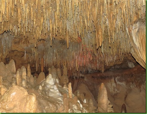
Stalactites (C for ceiling) and Stalagmites (G for ground) grow together to form columns.
 

IMG_3813


IMG_3828


David only bumped his head once! <grin>


IMG_3829


IMG_3833


The tour is 45 minutes long but it seems much shorter than that when we climb out.  I could definitely turn right around and go through again.  It’s really lovely. 


IMG_3835


In the afternoon I walk back over to the spring for a dip and bring my chair this time to do a little reading.  David joins me later and takes these pictures.  They’ve almost finished the spring run bridge.


The swimming spring.


The second spring.


He’s walking over the bridge between the two springs when he gets my picture.   I’ve already been in the water.


IMG_3839


IMG_3841


While he’s in the water, I snap this picture of a woman standing right in the walkway to the spring shouting into her cell phone.  I guess she’s using Skype or google hangout since she’s holding the phone up to talk to it.  I can hear every word of her conversation and have to stop reading until she is finished despite the fact that I am quite far away from her as you can see in the first picture. 


IMG_3845

IMG_3844


Tomorrow is our last day at Florida Caverns.  We will be heading straight back to Virginia beginning Saturday.  Our winter travels in Florida are coming to an end.

The River by Land is a Pulpit Trail

Wednesday April 8, 2015
Florida Caverns State Park
Marianna, Florida


While David is out doing his blood draw in Marianna this morning, I do a load of laundry at the campground bath house.  $1.50 to wash, $1.00 to dry.  I love staying in campgrounds with laundry facilities and hoard my laundry, if I can, until we are camped at one.  I don’t really mind laundromats that much except that they tend to be a lot more expensive.

After lunch we hike the River and Sink trails which can be reached from the campground.  My favorite parks are the ones where I don’t have to drive my car.

This will be a different view of the river from the one yesterday.  It’s a nice wooded trail in the Upland Hardwood Forest I talked about in my first post from Florida Caverns. Not what you usually see in the rest of Florida.


IMG_3598


Some sink holes are dry, and others are wet.  We even see one that still has metal trash in it.  No pictures of that one.


The light on this one makes it look blue and inviting for swimming but not a good idea.


IMG_3601


We’re hiking along when we see we have just missed the trillium here too. DARN!

IMG_3602


But then I spy these guys.  We haven’t missed the Jack in the Pulpit!


And there he is sticking his head out.


As we walk, we notice these piles of rolled sand balls.  Some are just hills but others are literal towers with a vertical tunnel going down through the center.  We don’t know what they are but they are all over the place.  

Later a ranger tells us they are made by the grasslands crayfish (crawdads in some parts)  not the stream- and swamp-dwelling kind. These crayfish rarely visit open bodies of water, preferring to spend their days in water-filled chambers three to six feet underground. Burrowing crayfish are seldom seen, exiting their burrows only in spring and summer on rainy or very humid nights to forage for food or search for mates. Their chimneys typically stand testament to wet ground, where the water table is very close to the surface.   That would certainly explain why we find so many on this River Trail.


We reach the river bank and  find large trees growing along it.  Testament to how long this river has been protected.   This makes me very happy.


The Chipola River begins in Houston County Alabama just north of here with Cowarts and Marshall Creeks which come together 6 miles south of the Florida Line to form the river.  I always thought a creek was smaller than a stream, that you could jump over a creek but had to wade across a stream, so I’m not sure how two creeks can form a river but perhaps it’s just a regional term.


IMG_3620


We find a nice sitting bench for enjoying the sights and sounds of the river.  From here the river  makes its way to the Apalachicola River a total of about 50 miles from where it began in Alabama.


The river looks brown or green depending on the light.


We see some of the big cypress we paddled by yesterday.  The size of these trees is awesome in the true sense of the word.


IMG_3627


The Chipola drains a basin of 781 square miles and has an average flow of 980 million gallons of water daily.  Water quality here is considered high largely due to the protection of the watershed.


IMG_3629


Now that we’ve noticed the jack in the pulpit, we see it everywhere along the trail.  It is definitely the wildflower of the day.

IMG_3633


IMG_3639


It’s so tempting to poke a stick down into the chimney but that wouldn’t be nice.  Looks like a lot of work for a fella only 2-3 inches long.

IMG_3643


IMG_3644


Now what do we have here?   Boy do these orange beauties stand out. They are pretty seriously technicolor.  


So is this stunning butterfly.  He seems to be called the red spotted purple but he sure looks blue to me.


It’s gotten warmer and warmer all through the afternoon so when our short 3.5 mile hike is finished we head back to Winnona and put on our suits.  Time for a dip in the spring.  We can walk there from the campsite.  LOVE THAT!

Here’s the side you aren’t allowed to swim in.

IMG_3661


And here I go into the side you are allowed.


FANTASTIC!   I have the whole place to myself.  Or I will until David comes in.


IMG_3671


IMG_3672


You just walk right out to the end of this floating dock and dive/jump into the cooling blue water.  It’s 35’ down so no problem hitting the bottom.


IMG_3677


David says his feet sink if he just lays back.  He has to move his hands or kick his feet.  Not me, I just stretch out and it’s like lying in bed.

IMG_3679


This is my kind of day with a walk along the river, a dip in the spring and then a walk back to the campsite starting between two springs.  We did a hike and had a swim and Ruby had the day off.


Tomorrow we’ll be going under ground to see how beautiful it is there. 
Temperatures are supposed to be in the mid 80’s outside so it will be great to be in the cool cave.