Go confidently in the direction of your dreams. Live the life you have imagined.

Henry David Thoreau

Wolf Howling and Moving On

Saturday May 13-Monday May 15, 2018                                                    Most Recent Posts:
Oregon Inlet to Lewis Mountain                                                         Before and After Currituck Light                   
Cape Hatteras NS to Shenandoah NP                                              Currituck Beach Lighthouse in Corolla              


SATURDAY


Saturday is really our last day at Oregon Inlet.  Tomorrow we’ll be packing up to move.  So today I’m up at dawn, spend the day on the beach and we visit Alligator River National Wildlife Refuge for a special after dark program.

It’s dawn when I see the moon setting.  It’s only a sliver of a moon but it looks beautiful in the sky and I of course take too many pictures.  But it’s my last dawn and sunrise over the ocean for quite a while and I just can’t help myself.

Consider it the anatomy of a sunrise.


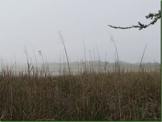
So quiet, only the ocean waves rolling and the grasses blowing.

IMG_3032


I can tell pretty soon exactly where the sun will come up.  Of course I know by now but you can tell too by the slight change in the color at that spot.


With dark clouds lining the horizon, soon the color shows higher in the sky.

IMG_3037


Here it is just peeking out and burning the dark away.


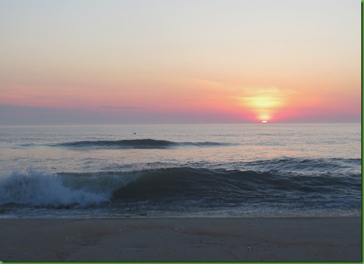
Blazing its path across the water.


Couldn’t choose, included them both.


Turning everything on the shore golden for just a moment.

IMG_3126


I love walking on the beach in the early morning when the colors are soft and most of the car tracks are gone at least from right near the water line.  The shells are exposed again.

IMG_3130


IMG_3141


Not another soul as far as I can see.  Truck marks, but no trucks – yet.


Just these guys in great numbers.

IMG_3157


Good thing they have wings.

IMG_3158


Wings make a quick escape possible.


IMG_3163


They also make scanning the waves for breakfast possible. 
This may be my favorite shot today.

IMG_3174


Calm before the waves.   Better grab a bite while you can.   I wonder why it took me so long to realize that life is all about eating?


IMG_3191


Or maybe this is my favorite

IMG_3201


One last look before heading back for breakfast.

IMG_3209


I took no pictures of  our afternoon on the beach.  This one of my favorite view with no trucks and no people in it for the moment will do.


In the evening we drive over to Alligator River National Wildlife Refuge on Manteo Island for their wolf howl.   They don’t promise a wolf howl, they just promise the opportunity.

And boy did a LOT of people show up including two bus loads of kids.  I guess we all love wolves unless we’re farmers or careless pet owners.   Hope you can get a feel for the numbers if not from the people then the cars in the background.  We counted 40 and quit.  Oh and 2 buses.


The ranger tells us about the sad story of the deminishing populations of the native Red Wolf and shows this map of their original territory.


I cropped it so you can see clearly that their range was all over New England, out to the Great Lakes and down to Texas.   The area marked as “final range” is where they were found naturally and from where species were captured for breeding and reintroduction.


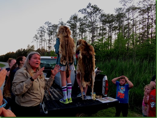
At its height in 2005-07 130 Red Wolves roamed the area..  They are now down to about 40 and their future is pretty dim.  The ranger shows us that their competition the coyote looks so much like them that wolves are often killed by farmers who mistake them for coyotes.  They also are now interbreeding with coyotes.    There just isn’t enough room with all the development for these predetors to thrive.   Two volunteers show us the difference between the fur of the two animals. Wish she’d put the smaller pelt on the smaller girl.  Which one is which?  I “think” the coyote is the larger one. 


The refuge has a captive group of wolves who have been hurt or are in need of attention.  These are the ones we are going to howl to.  

The other packs that roam free could be anywhere.  The ranger and wolf specialist know where this group is.   They bring us to this location up the road from the wolves.  They walk down closer and howl and the wolves howl back.  We can hear them.  What a wonderful eerie sound. 

Then the two come back up to us and we all howl too.   So loud, so many of us, I’m not surprised the wolves do not howl back.  We try 3 times with no luck.   Frankly, I think the wolves are smarter than this.  But it is the sad state of affairs on the east coast.  It does provide education and hopefully concern for the wolves that will translate into letters, phone calls, emails to those responsible for continuing and funding this program.  I lightened the picture considerably so it could be seen, that’s why the sky looks so odd.  It was pitch black and we could hardly see our hands in front of our faces.  Most of the pack of people is behind me.

Here are links to two very informative stories about the wolves’ fate.  One from 2016 and one from earlier this year.   After reading these, you can see the wolves need our help.


SUNDAY

On Sunday we’re in a race with the rain to get things packed up and under cover for our move north tomorrow.   We manage but the drive on Monday is rainy.


MONDAY

We leave early for our uncharacteristically long drive of 300 miles today.

We have to make stops for propane where they can’t get their credit card machine to work and we spend an hour while they try in vain and tell us they’ll call us when the charge goes through.  I don’t like leaving my credit card number but what’s the choice?  We don’t have enough cash.  

Then we have to stop for gas.  We pull into a Pilot to fill up the vehicles which also turns into a fiasco when you can’t pay at the pump which means you have to go inside, stand in line, estimate how much you’ll want then go out and pump it and come back inside with the real amount and get a promise of a refund.  OR do it all over again in the case of a $100 limit on a single pump or if you underestimated as I did.   So 5 trips back and forth and we’re back on the road.

I drive up the mountain to Shenandoah National Park ahead of Winnona to see what sort of walk in site we can get.  We’re aiming for Lewis Mountain Campground but if that’s not available then I’ll have to go further north to Big Meadows.


IMG_3239On the way up the mountain I am pummelled by hail which fortunately does not damage the car as far as I can see.   David arrives with the rig in time for a downpour.  Our first luck of the day, there are sites in Lewis Mountain.

I’ve picked two.  Both are paved.   One is double wide the other is more level.  He  likes the double wide but by the time we get in and level the tires are a foot off the ground so in mid storm he backs out and somehow manages to get us into the other site in what is now dark even though it’s not even 5:00. 

By the time it’s over,  I’m soaked and freezing from being outside directing the back in. But it is a level site thankfully.  It’s been a long day and  so much trouble with the site is really not what we needed at the end of it.

Of course if we’d been an hour later than we were we’d have missed it all since just after we get into the site  and leveled the rain stops

But it’s a portent of things to come.  The rain has followed us here.   The sunset and colors revive our spirits. 

IMG_3235


IMG_3246


It’s what Will said. . . . “alls well that ends well”. 

We’re safely on top of the mountain.
Tomorrow will be a better day
.

Before and After Currituck Light

Tuesday May 8-Friday May 11, 2018                                         Most Recent Posts
Cape Hatteras National Seashore                                             Currituck Beach Lighthouse in Corolla
Oregon Inlet Campground                                                         Kayaking in Alligator River National Wildlife Refuge
Nags Head North Carolina


The  days surrounding our visit to Currituck Beach Lighthouse are similar to the previous weeks -  mostly wind and rain.  We spend the time close to home other than the nicest day when we drive up to Corolla to see the 3rd of the 4 Outer Banks Lighthouses and the last one for this trip.


Tuesday

On Tuesday we got some new neighbors.  The most fun was a Killdeer.  He was just outside our dining room windows hopping all around.  Not sure what he was investigating..  He was out there quite a while and it was fun watching him.  He has such distinctive markings.


IMG_2743


IMG_2744


IMG_2745


On my way down to see the effects of the wind on the waves, I found this wind art in the sand.
Simply gorgeous.  I’m so glad I was the first person out this day so I could see it undisturbed.


IMG_2748


The effects of wind on sand and wind on water are both powerful.


IMG_2751


David was with me though he didn’t walk all the way down to the beach.  He could see the waves crashing from the end of the path.  Of course he turned around for the picture.


IMG_2755


On our way back we see that while we were gone two more new neighbors moved in on either side of us.  On the left is a little casita and on the right is an original 1968 Winnebago Brave.   These Braves are collectors’ items now and lots of folks are restoring them.   It will be 2054 before Winnona is that age. 


IMG_2757


IMG_2758


Fabulous restoration work.  It looks like new.  The fiberglass is clearer than Winnona’s.  A 50 year old RV.  Hats off to Winnebago.

IMG_2759


The casita seems to be all the rage these days.  New ones lose little value and used ones are gone less than a day after they are put on line for sale.   Is it a fad?  Will it last 50 years?


IMG_2760


WEDNESDAY

IMG_2895_thumb


My last post (link in blue at the top), was about our Wednesday visit to Currituck Beach Lighthouse in Corolla.  I promised to put our afternoon activities in my next post so here they are.

After visiting the  lighthouse, we walked around a small mostly commercial area known as Corolla Village with some interesting structures.  The ones we visit date from long before Corolla became a wealthy onclave.


IMG_2900_thumbThe village is located on the road just behind the light house and the first structure is the Corolla School which was built for the lightkeepers’ children in 1890.  By 1905 it had become the the First Unified Corolla School in the Currituck County School system.  By 1945 after the war the number of students dwindled as families moved out of Corolla in search of jobs.  By 1958, due to lack of students the county closed the school.  From then until 1970 when it became a private vacation home it was used by the Corolla Academy summer school as a recreation hall.  It was used for a number of other things for the next 40 years until in 2012 a charter school opened in the school house.  It is the smallest public school in North Carolina.  It is called the Waters Edge Village School and enables elementary students not to have to take a 1.5 hour trip to the mainland.

We were lucky enough on this Wednesday to find the school in session and an art project going on outside the builiding.

IMG_2910_thumb


IMG_2911_thumb


IMG_2906
Just outside the school fence I found a
Little Free Library.  I’ve seen them in many places we’ve been and love that they foster the sharing of books and reading in general.  Not to mention how cute they are.  After looking over the donations my choice was William Least Heat Moon’s Blue Highways which I think David will enjoy.  I wish I’d had some of my ‘ready to pass on’ books in the car to donate back.  I doubt we’ll be up this way again.  Lesson to me.  Keep them in the car when you finish them.


Next down the road was the Island Bookshop with one of the best mailboxes I’ve ever seen.  David was shocked that I didn’t go inside.  I know time can disappear when I’m in a book store and I want to have enough time for our hike.


IMG_2912_thumb


IMG_2914_thumb


IMG_2915_thumb


The last stop on our Corolla Village walk was the Corolla chapel just beyond the Bookshop.


In 1885 the community of Corolla formed an inter-denominational congregation in Corolla Village and built the original one room chapel.  Circuit riding preachers were sent to the village by horse and buggy on the beach front or by boat crossing Currituck Sound.

In the great depression the preachers were no longer coming regularly so the community used the building for a regular Sunday School and services whenever a preacher could be found.  Use of the chapel was sporatic and it fell into disuse around 1953.

It was sold as an abandoned property in 1962 to John W.  Austin who wanted to preserve it as a church.  He and his wife cared for it and left it to their son Norris.  Finally in 1987 Paster John  Strauss and his wife Ruth came to  Corolla and began holding year round services in 1988. 

By the late 1990’s the chapel was expanded to accomodate the increased attendance and Norris Austin donated it to the local congregation.  In keeping with the wishes of his father, the chapel remains inter-denominational.   They are clearly taking loving care of the expanded chapel.


IMG_2923_thumb


From there we drove to the end of the road so to speak.  Beyond the Currituck Banks Reserve
you have to have 4 wheel drive and proceed through the sand.  (Much to my dismay).


Currituck Banks is a Research Reserve, part of the National Estuarine Reserve System.  There are 29 reserves nation wide, 5 on the West Coast, 5 on the Gulf of Mexico, 14 on the East Coast, one each in Puerto Rico, Hawaii, Alaska, Wisconsin-Lake Superior and Ohio.   That last one really surprised me.   The only other one we’ve visited is in Wells Maine.  This one, known as the North Carolina Reserve, was acquired in 1984 by the state with assistance from The Nature Conservancy.

There are two short trails which lead out to different spots on the edge of Currituck Sound.

The red line shows the boundaries of the reserve.  Notice that it seems to go all the way to the Atlantic.  Keep that picture in mind when we get to the end of the longer trail.


We head down the main trail, which is a boardwalk through the maritime forest.

IMG_2929


It leads right out into the estuary.

IMG_2939


IMG_2941


Though not raining, it’s a gray day.  All the colors are neutralized.  There is a nest platform next to the boardwalk.  I wonder if an osprey would really build a nest that close to human activity.  Though I’m not sure this spot is heavily frequented.

IMG_2942


Those who can walk in the water don’t seem to mind our presence.

IMG_2943


If you’d like to sit for a spell, they’ve provided benches and an information sign.  Later in the year I suspect the insects might be quite annoying.

IMG_2945


We spend some time watching the egret fishing.


IMG_2949


Only with my zoom can I see his colors


Notice the tracks along the edge of the grasses leading toward or away from the osprey platform.   I can’t tell whose they are.

IMG_2950


Though there is no nest on the platform, the osprey comes by for just enough time that I can get this quick photo before we head back.

IMG_2951


It’s been a long day for David so he heads back to the car.  I want to see where the second trail goes since we will not be back any time soon.


If it were not for the blue trail markers, you’d never find your way to the shore or back to the boardwalk.  The leaf covered ground and forest all look the same to the untrained eye like mine.  Though the path seems to be evident at first, it quickly fades away.


When I reach the end, I’m surprised to find a broken bench facing mud and grasses.  Of course it’s deceptive becasue if you walk on out into that grass you’ll sink up to your knees or more.

IMG_2961


I stand carefully up on the bench and use my zoom lens to see what is in the distance.  What is it?  It’s so gray I can’t tell for sure but it looks like houses?   Remember the reserve borders all the way to the Atlantic.   Or is it dunes?  I don’t recall the dunes being that tall here.


The mystery remains.  I’d have to have a 4 WD to solve it.  So I just follow the blue trail posts back stopping along the way for a tree hug.  Such a lovely quiet place.  I soak in the rare experience of quiet.


IMG_2970


At this point I stop to look for the next pole since it’s unclear which way to go and I’m taken by the rich green moss on the ground.

IMG_2973


It really is as soft as it looks.


I return to the boardwalk and find David taking a nap.  It’s after 6pm and our drive is too long to head back to the rig for dinner.  We’re both hungry so I call Bob and Joan, Carrie’s in-laws, since I know they are here working on their beach house to open it up for the season.  Perhaps they’d like to grab a bite to eat even on such short notice.   Unfortunately they have just finished dinner but recommend their favorite pizza place where we meet them.  We eat and chat and I take no pictures.  Too busy enjoying their company.


THURSDAY

We spend some chilly non rain time watching the waves sitting on the beach between pick up trucks.

We don’t stay long.

IMG_2977


FRIDAY


20180511_122508

On Friday, like nearly every day, I take a walk on the beach.  This time to the south.  I’m sad to see this horsehoe crab body washed up on the shore.  In years past, I used to see many horseshoe crabs but it’s been years since I’ve seen one alive or dead.  In the 1990’s they were over harvested for bait and their numbers plummeted until regulations were put in place and they rebounded some..  But then a new manmade threat, in 2016 Scientific American reported that the medical industry harvesting the Horseshoe crabs for their blood is making their situation even worse.  I will never understand why humans cannot understand that if they “harvest” all or most of something they want be it horseshoe crabs or trees, there will eventually be no more.  Aren’t environmental regulations necessary to control our greed?

And speaking of regulations, here is one unpopular with local fishermen.  At certain times of the year, certain sections of the beach are closed to all traffic including foot and certainly trucks to enable the Piping Plover to be safe in its traditional nesting grounds.   I stop when I’m at that sign today.  It’s near the end of  Nags Head just at the tip and the Oregon Inlet.  There are miles of beach available here for fishing and driving but that doesn’t mitigate the complaining.


20180511_123007


I zoom in on the bridge construction.  I guess the birds don’t mind the noise.  Notice how much taller the new bridge in the foreground is in comparison with the old bridge in the background.  I wonder what happens to the “trash” of the old bridge that will have to be removed in order for ships to take advantage of the height of the new bridge.  Even if many won’t admit it, there is no “away” as in “throw it away”.

Notice the tire tracks.  I hope that’s the National Seashore rangers on Dune Buggies. 

20180511_123033


Headed back the other way I find the trucks have multiplied since I started my walk.


20180511_125542


One group is flying its flag high.  It’s half again as big as my Earth flag.  I still don’t get it.

20180511_125653


In the evening I drive over the old bridge across Oregon Inlet to the Pea Island National Wildlife Refuge boardwalk to watch the sun set over the marshes and the sound.


Singing down the Sun.


Next post will be the final one from Cape Hatteras National Seashore.
Time to move further north.