Friday November 28 and Saturday November 29, 2014
Fort Clinch State Park
Fernandina Beach, Florida
FRIDAY
It’s a chilly and very windy Black Friday. I call it Buy Nothing Day since that’s what I do in protest of the constant media barrage to “buy buy buy”.
Someone bought these guys some cute booties.

It was far too cold and windy for any beach time or even any walks on the beach. Here’s what happened instead.
The master re-stringer did the small shade next to the door. We are slowly replacing these with MCD shades as the budget allows. We’ve done the 4 most frequently used shades and the ones that have been restrung already once or twice. He’s become really good at this. You can tell how cold and windy it was. He normally does this on the picnic table but elected the living room floor for warmth. I don’t think there has been a day since we’ve been in Florida that we haven’t had our heater on.

We also hung up our bulletin board/white board, a great idea we got from Nancy and Bill. We get a great many good ideas from them. Thanks you two! I’m adding to “the lists”. Another example of how full time rving is just like any other life with those never ending lists.

SATURDAY
FINALLY, the rains have stopped, the winds die down and we have our first nice day in many days. We decide to head out to check out the other end of Amelia Island. Fort Clinch is on the North end of the island and Amelia Island State Park is on the South. We take “scenic” highway A1A from here to there.


This is really more of a recreation area than the usual state park. It is one of the few places on the east coast where you can ride horses on the beach. The 200 acres protect the southern tip of the island which is the northernmost of Florida’s east coast barrier islands. Mostly this is a spot for fishermen. There is no ranger station, no trails, no visitor center. There are wetlands surrounding the parking lot where we spend some time watching this great egret in his many poses.


Taking off

Landing

While we are doing that, as if on cue, a horse trailer pulls into the parking lot and begins unloading. Being a former horse owner and always horse lover, I have to go over and say hello. A sniff of the neck is also in order. I just love their distinctive smell. They’re not mine so I can’t really wrap my arms around their necks for a big hug and bury my nose.


We don’t stay around to watch them get tacked up but I hope we’ll see them out on the beach. We are headed over there when we get distracted.


The trail brings us up over the low dune for a view of three smoke stacks across the water.

These smoke stacks look just like the ones we saw when walking the beach near the River campground in Fort Clinch. When we get home David checks on the EPA site to find out what they are and how much toxic release they have.

He finds there are actually 6 facilities with a total toxic release of 3M pounds per year. This is 4.5 % of Florida’s total Toxic Release for the year. Together with the facilities near the campground, the total amount of toxic release from one end of the island to the other is 7% of the state’s entire total. The statistician did the math and that’s 19, 178 pounds of toxic release per day of which the overwhelming majority is air pollution. Boy that is a lot of pollution in this small area. Kind of makes you wonder about their claims of a pristine environment for Amelia Island. I guess what you can’t see won’t hurt you is the Chamber of Commerce’s motto.
If you want to check the TRI (toxic release information) for the area where you are, here is the web site. Search by zip code works best. Google can supply it if you don’t know it.

If you look away from the stacks, there is a nicer view.

But then around the corner, on the beach are also cars. We knew about the horses but we didn’t know that cars were allowed to drive on the beach here. I really don’t understand why we have to be able to take our cars everywhere. Off roading to ruin the desert and here to smash all the shells and other creatures. I am even more convinced when we walk on down the beach and see pick up trucks just racing around tearing up the sand.

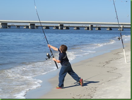
This little fella isn’t as big as his pole. At least, this family is fishing from their car rather than joy riding around in the sand.

I don’t know much about fishing but this looks like good form to me. Maybe he’ll grow up to use a fishing cart rather than a car on the beach.
We walk in the tire tracks. It would be a lovelier beach if we’d just keep the cars off of it.


At the tip of the island we finally spot the no cars sign. Those three little brown things mark the end of driving. As you can see, the tip of the island is a very broad sandy beach but because of the cars, there are no folks out here today with their chairs, towels and toys despite the fact that it is nice and warm and not windy here.

Currently one of the three signs is actually out in the water.


There are also interior “roads” which make for even faster racing. We take one of them back hoping to see the horses on their way out to the beach. We do catch a glimpse of them far in the distance on another interior road. Perhaps there are horse trails here. We’re not sure.

On to Big Talbot State Park.

We head across the bridge from Amelia Island State Park (small pink arrow at the top of the map) to visit Big and Little Talbot Island State Parks. Immediately there is a sign for Big Talbot and we pull in. But it turns out to be a parking lot for fishermen. There is a boat launch and it looks like some nice trails into salt marsh.
We are looking for Big Talbot State Park so after a couple loops around the parking areas we determine this isn’t it and we don’t stop here.
Later we learn that it is the George Crady Bridge Fishing Pier. There is actually an old bridge which was turned into a fishing pier and bike bridge. Sounds like a place to come back and investigate in terms of biking and kayaking.
Big Talbot is described as being “located on one of the sea islands of Northern Florida. Primarily a nature preserve and a premier location for nature study, bird watching and photography, centuries of wind and water have eroded the island creating the park’s famous “boneyard “beach” which is covered with the skeletons of live oak and cedar trees that once grew near the ocean.”
We turn left at the next Big Talbot sign (small blue arrow marked “The Bluffs” on the map) and find ourselves in a picnic area. No Bluffs sign here, no ranger station or visitor center. But there is a sign saying Shoreline Access Trail so we think we’ll have lunch here.
We take a look around and walk up to the ‘easy to access no trail required’ overlook where we see a hammock hanging below on one of the “bones” for which the beach is known. Here’s a close up of the hammock with its residents. Notice the shoes. Can you find it in the more distant picture of the beach. They are hanging out there right above the water about 4 feet I’d guess.


The information we got beforehand about the park says it has 3 trails, a boat ramp and canoe and kayak rentals. We don’t see any of these here. We find out later that the hikes have separate parking along A1A further down. The information also says you can “picnic on the bluffs”, which seems to be where the Shoreline access trail goes, and “visit the beach to sunbathe or stroll along the shore”. So off we go with picnic in hand. The trail gets narrower and narrower as we walk. It’s a very nice woods up here on the bluff.


There aren’t any spots to picnic up here. All the tables and benches are back around the parking lot. We think we’ll go down on the beach and sit on some bones but we see that at this point, there is no beach. Must be hoy toyd.

We find a little larger “cove” where we can sit on the edge in the sand and not have our feet get wet. It becomes the picnic spot.

We’d have preferred a spot in the sun since it is not nearly as warm here as it was on the other side of the water in Amelia Island State Park where the sun is shining. But this works just fine. The “boneyard” reminds me of Hunting Island State Park in South Carolina although there is a much wider and deeper beach there.

On our way back to the car we spot this giant white…….what? fungus? I have no idea, I’ve never seen it before. It is bigger than David’s fist.


Isn’t it interesting? Do you know what it is??

When we return, the ranger has been around so we check to see if the hammock is still there. It is, and it looks like the occupants are still there too. But notice the shoes and the shirt are gone. Hmmmmmm We can’t hang around to wait out this mystery and see if they spend the night there. We have to be off to Little Talbot State Park before we run out of daylight which is shortly after 5:00 these days with this time change business.


Little Talbot Island State Park is just a mile down the road from Big Talbot. It’s 1872 acres and has a 5 mile long beach and 40 site campground. It also has a ranger station where I am able to get all the stamps for my Florida Passport book for all three parks we visited today. SCORE!
They have what is described as a “nature trail”. We assume this is a short interpretive thing since that’s usually what nature trail means. So we head down to the end of the road to the last of the 3 parking lots each with a couple hundred of spaces. This place must be hoppin’ in the summer time. We take the long boardwalk out to the beach. The board walk actually goes most of the way out but the last section is on dry land. Well actually not so dry today after the rains of the recent past.


This is the beach of the day. Folks are laying out soaking up the sun. It is really wide and flat with waves lazily rolling in from long distances away. It’s the size beach those parking lots need.

When we turn to the right, I am surprised to see that we are very close to the Mayport Naval Base.

Looking the other way appears to be most of the 5 miles of the park’s shoreline.

We walk along enjoying the waves, the patterns in the sand, including the footprints, and the shells. Beaches are wonderful places. Always different, always beautiful.


As usual, we collect our favorite treasures along the way. At the end of the hike we put them all together for a portrait. Here is today’s grouping.


We think we have just enough time to do the nature trail and get back before sunset. But when we stop in the ranger station to find out exactly where it is, she tells us it is 4.5 miles long. Opps! Never ASSUME!! Well now we have a couple of reasons to return to the Talbots. There seems to be biking, kayaking and a 4.5 mile trail we need to do. Not sure we have enough time left for all of that. We’ve lost quite a bit to weather.
When we return for dinner things are hopping in the sites next to us. A 38+ foot motorhome with temporary tags has moved in and set up their outdoor football watching which extends into the night and after dark. Here’s the view out our dining room window. I can’t quite tell who’s playing but I can hear the play by play with no trouble.

They are part of the group that has occupied the two sites down from us since Wednesday. This group includes about a dozen kids and 4 golf carts. You can see Winnona there on the far left. They have pretty much taken over this end of the campground.

They even have a “patio” set up complete with chairs and a cooler on their trailer parked in overflow parking across from their sites.

The park street is full of scooters, bikes, golf carts.


Sunday is tomorrow and I’m betting the gang will be gone.
The sun sets on us all at the end of another day. Aren’t we lucky to see it!
