Monday & Tuesday July 30 & 31, 2018 Most Recent Posts
Great Smoky Mountains National Park More Cades Cove and Hen Wallow Falls-GSMNP
Tennessee Dominos and No Llamas
MONDAY
This morning I am up and on the road early enough to see the sunrise along Laurel Cove Road as I drive through the park to the Old Sugarlands Trailhead located just beyond the Sugarlands Visitor Center. It is one of the shortest drives to a trailhead so far.


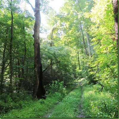
The trailhead is right off of the road to Gatlinburg, Rt 441, beyond the visitor center. Parking for 4 or 5 cars max is along the road but the trail seems little used possibly because it doesn’t really go to any waterfall or any peak. But that’s OK with me. Walking along the West Prong of the Little Pigeon River suits me just fine.

The trail is a smooth old roadbed beside the river. It used to be Tennessee Highway 71 and ran through the heart of the Sugarlands Community one of the oldest communities in the Smokies and named, it is thought, for the abundance of Sugar Maple Trees that once grew in the area. It was a thriving community in the early 1800s.

The sound of the rushing water draws me down to the water’s edge and I take advantage of one of several opportunities to explore the river bank.

What a beautiful river!


Along much of the trail there is an overabundance of poison ivy which I am very careful to avoid. In the picture below it is the dark green 3 leafed plant. Just below it is the harmless 5 leaf Virginia Creeper. Or at least I’ve always found it harmless.

As the trail turns east and ascends the western flank of LeConte Ridge, it gets steeper and rockier.

When I look down toward the river a deer is crossing to the other side. Easy if you have 4 feet and permanent boots.

The trail continues through narrow rhododendron and fetterbush tunnels.


I come to a sign that doesn’t really clearly indicate which way to continue on the Old Sugarlands Trail.

Seems like it probably goes straight but since to the right goes down to the water, I take that one to check it out.

Sure enough, I come to the river and perhaps in times of less water there is a way to hop stones across.

Although there are cobbles of all sizes and shapes, there’s no way to get across without wet feet and I don’t see a trail on the other side anyway.


The trail drops back down again and follows the river. The forest becomes dense.


Shortly I come to the remains of a CCC camp including the old clock tower.


The forest is clearly taking over in the 80+ years since the CCC was here.

Previous hikers have kindly left what they have found in full view for others to examine.

I begin to climb into the sunlight.

Keeping a close eye out for the former homesteads of the residents of the Sugarlands Community I find rock walls and more.


A little Carolina Wren hops into my path among the fall looking leaves I pass

It’s only the end of July but what I assume are sugar maples are leaving their colorful calling cards.

The path has widened back to road size but becomes more and more overgrown as it continues up the mountain among remnants of the old homestead.


Not sure who this little fellow is but I thought he was a lovely stand out on his green leaf.

Remnants of the community continue.

I walk back off the trail into one homestead area and find many metal tubs and cans.

I don’t inspect very closely as these relics are heavily guarded by poison ivy.

Even the pottery, possibly put here by someone during the winter.


Along the way there has been lots of evidence that this area was hit very hard by the fires of 2016 which claimed the lives of 14 people, injured 134, burned more than 10,000 acres, 15 square miles, inside the park and 6,000 acres outside. 14,000 people were forced to evacuate and 2000 buildings destroyed. The fires were the deadliest in the Eastern U.S. since the great fire in Bar Harbor Maine/Acadia National Park in 1947.
The entire trunk of this tree was burned out and yet up at the very top, it lives on.

More evidence of the communities – high tops from shoes and other things collected by previous hikers.


A fork off to the right takes me, in about 3/4 mile, to the Old Sugarlands Cemetery which is one of the largest I’ve seen in the park and quite a hike for those who maintain it.


Back to the fork in the trail, I take another fork off to the left just to see what’s there. When I come upon this hiker made sign, I’m sorely tempted but I’ve traveled over 3 1/2 miles at this point and am not sure what 20 minutes would mean in terms of miles as this trail narrows and gets more sketchy from what I can see ahead. Reluctantly I turn back vowing to come again directly here with no stops for looking at everything else.
On the way back, of course, I see things I did not see coming. One of them was this wild boar trap that I first thought might be the stone house through the trees and underbrush until I worked my way closer..


One sample of the many mushrooms along the trail.

But the BIG thing I did not see on the way up the trail was this black thing in the trail ahead of me. I stop. I take a quick picture and then zoom in.

Zoomed in, it looks like she sees me too. What a beauty!

Even better, there’s a cub.

Really better – two cubs!


I just keep snapping away. She’s watching but doesn’t seem worried. Cubs are playing.


Here’s a video of what happened next. I guess she decides since I’m not moving she will.

The kids head for the trees.


I wait a while and then walk on down the trail toward my car. When I get to the spot where they were, there’s no sign of them. What a fabulous way to end a great hike. Really want to return to find that rock house and maybe other bears!
TUESDAY
Tuesday is the last day of Bill and Nancy’s two month stay here in Wear Valley outside the Great Smoky Mountains National Park. They came in early June, the month before I did and are leaving at the end of July, leaving me here for another month.
They had been once to the restaurant right across from my park called Geppettos and wanted to return so we had dinner there together as a send off for them.

They had the same things they had the first time since they liked them so well. Lasagna for Nancy and Chicken Parmesan for Bill. I joined Nancy in having the lasagna. Amazingly I forgot to bring my camera with me so no pictures of the food.

All of these pictures are from Nancy’s camera including this one I took of them. I think they are happy with their dinner and happy to be moving on down the road. Despite the great hiking both months had a lot of rain and heat in the Wear’s Valley of Tennessee outside the Great Smoky Mountains National Park. I sure will miss their company as I hike on.
