Go confidently in the direction of your dreams. Live the life you have imagined.

Henry David Thoreau

Saturday Morning in Cades Cove

Saturday July 21, 2018                                                                     Most Recent Posts:
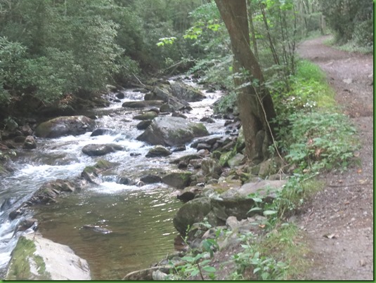
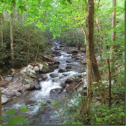
Cades Cove                                                                                        Middle Prong Trail and Falls
Great Smoky Mountains National Park Tennessee                            Alum Cave Hike With Nancy & Bill


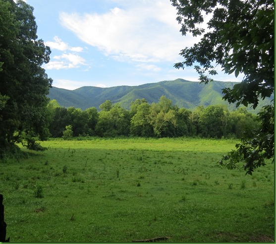
Saturday morning is one of the days when the park service closes the Cades Cove auto loop to motor vehicles and turns it over to walkers and bikers and runners.  I start out at about 7:30 walking down the road and enjoying the views of the high valley surrounded by mountains.


The low lying clouds and fog are lifting and they are great to watch


This morning turns out to be a morning for the birds.  This goldfinch and his friends are all over the seeds from these grasses in the fields.

IMG_8738


I spy a pewee on one of the fences in the woods.

IMG_8743


Looks like this Eastern Bluebird is resting on a sign along the road with a morsel in his bill.


I wonder if this juvenile Blue Bird is the intended recipient of the morsel.  He looks rather large to be depending on his parents to provide his food.


I was very lucky to get this yellow throated warbler who flitted all around the tree before I finally got a decent picture of him.  Wonderful seeing all these birds.   This is the reason I walk.  I wouldn’t see any of them if I were in a car or even on a bike or running.

IMG_8760-yellow throated warbler


But we did bike it on our last trip here in 2011 and if you like biking and can do 11 miles of up and down, there isn’t a prettier bike path anywhere I don’t think.

IMG_8765


I love the folds in these mountains.


Since both Downy and Hairy woodpeckers are frequent and permanent residents in Great Smoky Mountains National Park, I’m not positive who this is but I’m guessing it’s a Downy based on the bill.


IMG_8773-female downy


The orange butterfly plant stands out starkly in the field.


We’ve had a LOT of rain here nearly every afternoon and the water on Sparks Lane, which is one of the cross overs for those who don’t want to do the entire loop,  is running over the road.  With this in mind I’ve actually worn my hiking boots rather than walking shoes which would be fine for road walking.

IMG_8786


IMG_8790


There are actually ripples as it moves across the road.  Turns out it’s a little deeper even than I want to go in hiking boots since it will cover the whole top of the boot.  That would be OK if I was on a trail and had to, but there are no rocks to hop over here and since I have a choice I turn around and head back.

IMG_8791


I continue on the main loop road and decide to walk up the quarter mile lane to the John Oliver House. 

John and Lucretia (now that’s a name you don’t hear any more) Oliver arrived in Cades Cove in 1818, one of the first European Settlers to arrive.  Their home is one of the oldest structures in the park.  Members of the Oliver Family lived here until removal.

This photograph is on the information board.  It was taken in 1957.


The park has done a wonderful job of maintaining the house.  Notice the foundation in the next two pictures.

IMG_8811


It’s a one room cabin with a loft and only two windows.  Most of the air conditioning came from having both the front and the back doors open to any breeze.  I can look right through the house.

IMG_8812


It’s so dark inside that I had to use  my flash.   I think the little door on the right is for firewood storage under the stairs.


Steep stairs to the loft.


Notice the front door hinge and handle.


I think these hinges are so clever.  You never have to oil them.

IMG_8822


A throw bolt door lock only requires a hole to shove it into.  A bit harder to break into than our modern doors.

IMG_8823


These foundations just amaze me.  The whole house sits on rocks.

IMG_8840


IMG_8841


  The Rich Mountain Trail leads through the John Oliver property.  I may hike some of it on another day.


IMG_8839
 

Here’s the view from the back porch over the field I’m going to walk through as I leave rather than take the lane through the woods that I used to get here.  I can imagine sitting in a rocker on this porch stringing beans and loving the view.

IMG_8833


There are a couple of paths mowed through the field to make the hiking more tick free.  I take the path that seems to have less standing water.

IMG_8848


Back on the road, it’s nearly time to go return if I don’t want to be sharing the road with a line of incoming cars all moving at a snale’s pace.  I so appreciate the quiet with no motors.  I can hear the wind, the birds, things that get drowned out in our hectic automotive filled lives.

IMG_8868


I pass some birds of a feather.  I see them every time I come.  Still haven’t seen the gobbler.  He must be around somewhere.

IMG_8877


The last bird I see is perhaps not the same one I saw earlier but the Eastern Wood Pewee looks me in the eye and then turns his back to me and over his shoulder seems to say good bye.

IMG_8881-Eastern Wood Pewee


IMG_8887

Cades Cove is a wonderful place to spend a Saturday morning.  It’s a unique spot in this fantastic National Park.

GSMNP: Middle Prong Trail and Falls

Thursday July 19, 2018                                                                                  Most Recent Posts:
Great Smoky Mountain National Park                                                             Alum  Cave with Nancy & Bill
Tennessee                                                                                                      Abrams Falls in Cades Cove


IMG_8430If you’ve been following along you’ll know that I’ve done two hikes in the Tremont area recently.  Today I’m back to Tremont Road to do the last hike in this area.  At least the last one for me. 

I’m up early so I can arrive at 7am after driving half an hour down to the Townsend Y entrance to the park and then to the end of the gravel Tremont Road where I find only one other car in the parking lot.  That could easily be an early morning fly fisherman.  They love the streams in the Smokies for trout fishing. 


IMG_8432
The trail begins at the confluence of the Lynn Camp Prong and the Thunderhead Prong, at the point where the Middle Prong of the Little River officially begins.  As you can see from the sign, horses are welcome.

Just past the metal footbridge near the trailhead is the former site of a community known as Tremont. In its heyday the lumber camp consisted of a post office, hotel, a general store, maintenance sheds, and a community center that also served as a church, school, and movie theater.


Pretty sure this is the Lynn Camp Prong flowing toward and under the bridge as I cross over


Like many other trails in the Great Smokies that appear to be a gravel road, the Middle Prong Trail was actually a railroad bed that was used by the Little River Lumber Company to haul logs out of the area. After logging operations ceased within park boundaries, the Civilian Conservation Corps converted many of the old railroad beds into roads and trails.   I’m going beyond Panther Creek and almost to Greenbrier Ridge.

IMG_8437


Middle Prong Trail is a quintessential Great Smoky Mountains river hike.  It rises gently along the Lynn Camp Prong where the water is almost never out of hearing and seldom out of sight.


Isn’t this just a fairy tale trail with the wall of rhododendron on the right.  A few weeks ago it would have been in full bloom.


At less than half a mile I come to the Lower Lynn Camp Falls which pour down a long sloping rock slide..  It’s a tall multi tiered falls that is very impressive though the falls are set back and partially concealed.  It is difficult to get good pictures from the trail through the trees.


IMG_8446


Great viewing spot from the bench but the camera just can’t give you the majesty that you experience seeing and listening to Lower Lynn Camp Falls.

IMG_8447


This is the bottom tier through the trees.   I pass up the possibility of carefully descending to the bottom for better shots look up thinking perhaps I’ll do that on the way back.   It’s a long way down with no clear path and I’m loath to damage the environment and create erosion possibilities.

IMG_8448


Instead I opt to go around the side on the rocks themselves which will not be bothered by my footsteps.  Note that the rocks I’m on are dry.  Wet rocks are way too dangerous.

From here I can look down on a couple of the tiers dropping down the slide.

IMG_8462


I’m on the side of the top tier at this point.  It really is magnificient.  If you’d like to see and hear it in motion, click this link for a short video.


Back on the trail, the music continues.  I’m still right beside it.


Soon I move up for a view from at least somewhat above the water rushing to the falls.

IMG_8482


This, I think, is what is known as Lynn Camp Falls as opposed to Lower Lynn Camp Falls.  It too is a series of cascades but rather than flowing over a rock face, they run down the river.

IMG_8490


IMG_8489


.

IMG_8494


From this viewing bench, I can easily see both the cascade above and the one beneath it shown in the picture below.   They are not so easily seen around the tree trunks in the picture but it does record the setting


IMG_8495


IMG_8507


I don’t remember this small fall just along the trail being mentioned in anything I read.  It’s a sweet surprise.

IMG_8509


If this was a road at any time, I have no idea how anything with wheels would manage.  Even the foot bridge is rugged.

IMG_8520


IMG_8523


IMG_8526


At 2.3 miles, I reach the junction with Panther Creek Trail on my left. I take a look and see that there is no bridge and you’ll have to make a wet water crossing over Lynn Camp Prong if you want to go that direction.  Better have hiking poles or a horse.

I continue straight on the main trail.


IMG_8533


The trail progresses with rhododendron growing along the edges and dropping petals on the trail.  The blooms are at the end of their peak but there are still lovely ones along the way.  The grade steadily increases as the trail makes several sharp left-hand switchbacks followed by a right-hand switchback

IMG_8544


IMG_8543


There are some but few signs of the many homes that were here in the mountains before removal.  The last time I was here, this chimney was standing erect.  But there is no sign of the home to which it once belonged.


At 3.5 miles this bridge crosses the Indian Flats Prong and begins to climb more steadily.  I know at this point I’m getting close.

IMG_8548


In slightly less than another half mile, I come up to what was once a turn around and is now where the trail turns hard to the left.  I know to look on the right for the nearly hidden spur trail that leads to Indian Flats Falls.

IMG_8584


Certainly not an obvious spur but you can hear the falls if you listen.

IMG_8585


The spur trail is dense and on the rough side with blow downs.  It’s a narrow path right on the edge of the mountain.  I take it slowly and carefully

IMG_8575


IMG_8581


After I come down this rock slab, I turn around to get this picture.  I think going back up and out will be easier.

IMG_8573


When I step down onto the flat near the falls I do the same thing, I look back.  Going up will be easier than coming down.  It has helped on this spur to be short and not have to bend over so far to avoid the over growth.


IMG_8572


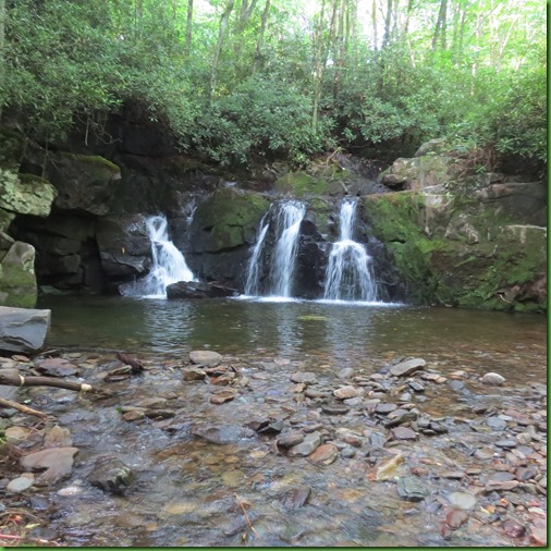
When I am able to look up and ahead of me I am greeted with the lovely sight of  Indian Flats Falls.

Indian Flats Falls includes four separate scenic drops. However, only the uppermost drop is easily accessible. From here I’d have to scramble over boulders and under rhododendron thickets in order to reach the additional drops, which is inadvisable even in the best weather. Not only will doing so risk my own safety, but I’d also unnecessarily damage the vegetation and soil along the creek bank.


In total, the waterfall drops roughly 60 feet in three separate tiers, with the top tier dropping roughly 20 feet. The middle tier is located near the end of the spur trail. 

I can get to a position where I can take this shot over the ledge to the middle tier going down stream. But I can’t find a position where I can look downstream to see the lower tier. 


IMG_8559


Check out this video to hear the falls and get a much better idea of the lay of the land.


It’s a lovely spot and I sit myself down on a rock and stay for a while.  I’ve come nearly 4 and a quarter miles up a beautiful trail and this is a fitting view to celebrate how lucky I am to be able to do such things and that we all are to have such places to enjoy.  My gratitude for it all is enormous.


On the way back, the trail is just as wonderful, the prong just as delightful and as always I see things I missed on my way up like the leaves of this Wake Robin, giant trillium.  I take this shot just to show how large the leaves are.  I’m sorry to be too late for the blooms, they are exceptional.

IMG_8592


Right nearby I find one where the stem is apparently broken and the bloom got red but did not open.  The color is fabulous and the flower’s size is in keeping with the leaves.  Wish I’d been here earlier to see them.

IMG_8595


Are there ever too many pictures of this beautiful Smoky Mountain waterway.?  The park is just filled with outstanding rivers and streams just like this one.


IMG_8634


It’s just after 11am when I meet these riders coming up the trail.  They’ve left their horse trailer in the parking lot.

IMG_8649


I pass several small gatherings like this at my feet.  They definitely blend right in.


IMG_8651


Not so for this Orange Fritillary who stands out against the gray rocks of the trail.


IMG_8669


A Slightly better view with different light gives a better picture of the unnamed falls at about the two mile point.  This trail has several falls and even more cascades.


No post of a trail in Great Smoky Mountains National park would be complete without at least one fungi picture.  This was my favorite today.

IMG_8678


IMG_8680


One last reminder that while the trail is gravel and on an old road bed at a reasonable grade MOST of the time.  It’s not all smooth easy going.

IMG_8683


But it is all beautiful and one of my favorite hikes in the park., all 8.29 miles and 21891 steps of it.   This is the closest thing I saw to an otter today.  At least it looks like one to me.

IMG_8695