Tuesday June 24 and Wednesday June 25, 2014
Fort Wilkins State Park Campground
Copper Harbor, Michigan
TUESDAY June 24
Looks like the ocean doesn’t it?

Today Lake Superior decided what everyone would do, stay inside. It rained, the winds blew and the waves put on a show.


I can see through the trees in two different spots so I watch the waves swell up and crash down. The sound is as forceful as it looks.


All day long we listen to the wind howl and the waves smash into the rocks and each other. It is GREAT!


All day long that is except for the afternoon trip into Ontonagon David takes to pick up Syl’s pasties for dinner. With a name like that, we know the pasties will be good. It’s 17 miles to the big town.
Ontonagon is a cute little town with several cafes, bars and restaurants and great old architecture on many of its buildings. Like most towns however it also has some forgettable new architecture which may have replaced other old beauties.


Syl’s seems to be a popular place which would indicate good food. The bakery case looks yummy. David picks up an apple fritter to eat on the way home. He declares that it was “GREAT though it would have been even better warmed”. I know he was thinking we should have come to town earlier and eaten breakfast at Syl’s.


Syl’s pasties are the kind we had always seen before in the half round shape made by one circle of dough filled and then turned over the filling with the top crimped. They are so good we totally forget to take a picture. We pronounce them to be better than Muldoon’s in Munising. Wonder who does the voting on UP’s best pasties?
It doesn’t rain all day but the wind blows powerfully and the waves pound the rocks.
What a wonderful sound and what a send off for us on our last day at Porcupine Mountain Wilderness State Park.
Lake Superior put on a great show.


Tomorrow we leave for a 115 mile drive straight up the Keweenaw Peninsula to Copper Harbor, the Northern most Michigan town on Lake Superior

WEDNESDAY June 25
We have plenty of time to do all our pack up this morning since our drive is a relatively short 115 miles. Today is that bright clear sky day that often follows after a storm has washed everything clean.
We say good bye to the Porkies. We have had a wonderful time here, won’t hesitate to return and recommend it highly to you.
Our trip is east straight out of the park and a left turn North up route 41 from the bottom of the Keweenaw Peninsula to the top.

We pass through Houghton and cross over into Hancock on the Portage Lake Lift Bridge which spans the narrow end of Portage Lake. The bridge is distinctive in my experience since I’ve never been on a lift bridge.
Built in 1959, it’s the heaviest aerial lift bridge in the world. The unique double deck bridge has two levels of traffic. The upper level is for vehicles while the lower is for pedestrians and in winter, snowmobiles. The lower level was originally used for trains which, like in many places, no longer run in the Keweenaw and the rails have been removed. This is the only entrance to the tip of the Keweenaw and Copper Harbor unless you go by boat. The bridge can be raised for boat traffic.
The first picture of the bridge is from the web. This is a summer picture in which the bridge has been raised so vehicles can travel on the lower section and boats up to 35’ can travel under it without the bridge having to be raised. I guess too bad for foot traffic since the upper lane is now up in the air. The second picture is our view as we cross it. I think the bridge is lowered at this time and we are going across the top level. Pretty clever engineering.


We arrive at Fort Wilkins State Park in Copper Harbor and happily they have several sites we can choose from for our 5 night stay. I had checked earlier on line to make sure there were sites before we drove up. We take Ruby and look them over.
I prefer site 151 in the West Campground where the sites are bigger and more separated with greater privacy. There are also at least 6 pull throughs that look out on the lake but of course all of those are reserved.
David likes site 28, one of the only 2 available, in the East campground. His reasoning is that since the wifi is only working in the east and there is NO internet, phone or data, in Copper Harbor, we will be happier even in the more crowded campground if I can post the blog without much trouble. We take site 28. Therefore you are receiving this post.

For the first time in weeks, it is actually warm enough to leave the door open. This is cause for celebration. It has been “summer” for 4 days now and it finally feels a little bit like it.
We decide to try out the bike trail into town and see the big town of Copper Harbor. All 30 blocks of it.
From the map, you can see Fort Wilkins is out of town to the East the arrow on the far left. It’s just over a mile to the campground from town. Route 41 dead ends another couple of miles past the campground. That’s the end of the road that goes all the way to Miami Florida. An original North/South route.


This picture of me riding shows one of the only flat stretches on this trail obviously designed for mountain bikers. I don’t mind reasonable inclines but this trail has short steep ups and downs. Pretty difficult for us on hybrid bikes in big gravel.
We later discover that apparently Copper Harbor is one of the mountain biking capitols of the country and pretty much all the “bike trails” are rough mountain biking terrain. I must try to remember when asking about biking to say I don’t mean mountain biking since that seems to be what most people providing information assume you mean.
As we cross Fanny Hooe Creek (yes you heard me right), I stop for a picture of the lovely stone highway bridge only a short distance away. The masonry on this bridge built in the 1920’s is exquisite. I wonder if we make any bridges this lovely any more. Not only is it useful but it is beautiful too. I so wish we had beauty rather than economy as our top priority in creating our structures today.

We stop on the foot/bike bridge to take a picture of Fanny Hooe Creek as she flows into Lake Fanny Hoo. As for the name, the story goes that there was a woman, wife of a soldier at the fort, who went out berry picking and never came back. Bears? Indians? Pretty sure a black bear wouldn’t eat her although he might maul her if she was in his berry patch but then you’d likely find a body. Right? As for the Indian story, well isn’t that always the story? Red man steals white woman. Who knows. It’s a legend. Perhaps the real truth is that someone’s Aunt was named Fanny Hooe and she lived near the creek.


The trail circles by Fort Wilkins which is the only remaining wooden fort east of the Mississippi. We’re not great Fort visitors but since it is right here, we’ll walk over one day while we are here. The main building is closed until August so they can repair the roof.

At many points the trail runs right next to the much flatter Route 41 which is the only road in or out of Copper Harbor and is without the roller coaster effect of this trail. Obviously the only pictures taken are on the flat. I am too busy rapidly changing gears otherwise.

We do make it to town and vow to just ride the road back. We take the first street to the right aptly named 1st Street.
The houses here are cute. Copper Harbor’s full time population is 132 so many of the houses we are seeing are summer cottages. The community depends on tourism in the short summer season for its livelihood now that Copper Mining is no longer in the region. Their beautiful natural setting is now their money maker. They are known of course for their beautiful lakefront, for the available hiking, the boat to Isle Royale, lighthouses in the area, falls in the area, mountain biking, ATVing, fishing, boating, swimming (for the hardy) and many winter sports including snowmobiling, cross country skiing and snow shoeing, sometimes across the lake.
The mountain biking trails are numerous and well marked. They appear to have been done with great care for the environment. Most are single track, some like the one we took to town and hiking/biking beginner trails. The ATVing appears to all be on the dirt back roads and thus also does not tear up the environment which is now so important to their economy.

In two blocks, 1st Street like the other 9 streets ends at Lake Superior. See the above city map for clarification. We cycle down Brockway to the municipal park and take this picture of the opening into Copper Harbor. The Copper Harbor Lighthouse is out there on the right arm. My camera can get a picture of it from here. The only access is by boat. There is a $17 trip including tour that we may take if time and weather permit.


At the Waterfront Landing we find Jameson’s Fish Market and Bakery. Unfortunately for David they closed at 3PM. During the summer I’ll bet they do a good business for pastries and coffee with patrons sitting outside at the picnic table or in this double chair overlooking the lake.


The Isle Royale Queen IV is docked next to Jameson’s. As we walk by, we can hear her ropes pulling against the lake’s waves. But the ropes are securely tied.
Isle Royale National Park is 55 miles northwest of Copper Harbor. It is Lake Superior’s largest island. It is 99% wilderness with 165 miles of trails and 36 campgrounds. This is backpacking camping, no vehicles on the island. Other than camping, there is only one place to stay, the Rock Harbor Lodge which has motel style rooms and duplex cabins. All travel is by boat or foot. . There are no roads or even two tracks.

The cost is $120 per person round trip to travel on the Isle Royale Queen IV for the 3.5 hours of travel each way. Just for fun, I looked up what it cost us to go over and stay when we went from here in 1991. For two adults and one child it was a total of $160 round trip.
We aren’t prepared for going there on this trip and think the mosquitoes might be prohibitive at this time of year. If we were going up to Grand Portage Minnesota, which I don’t think we are, we might do the the $60 for a day trip which is only a 1.5 hour ride with 4 hours on the island and then the trip back. It’s true, 3 hours on the boat, 4 hours on the island is barely 50/50 on your time. I’d like it better if the ratio were 3 to 6. But I doubt we’ll do it this trip anyway.
At this point, we can bike no further on Brockway; there is water in the way. We have to turn left up 6th street, go over one block on Bernard, turn right on 7th and then left to come back to the water front street which is now called Harbor. On Bernard, we pass some of the numerous rental cottages in the town and area of Copper Harbor.

This one is around the corner on 7th and has clearly been turned into someone’s home. It has a gorgeous garden in the front.

This is Harbor Street. Not sure two cars could pass on it. All the cottages and homes on Harbor seem to have been built at the same time. They are all waterfront and you can tell which ones are cottages because their windows are sealed shut.


You can tell which ones are homes by the amount of firewood stacked outside.


This photo is for my friend and Retriever mama Pam. If I could have found one to buy, I’d have sent it to you.

I think this is where I want to live, in the land of make believe.


Nominee for this year’s best license plate. Wish I’d thought of it.

OK, so what’s this? We pass it on the main street as we head down the 10 blocks from 10th street to 1st and out of town. No sign, no indication but really interesting.


Seeing the whole town takes only a couple of hours including the bike back up the road for a mile.
We get some dinner and decide to investigate the only place in town that has cell service, the top of Brockway Mountain. We get no Verizon cell or data service here. Our antenna and booster are of no use. Brockway Mountain blocks all signals. There is wi-fi in the campground though the west router is out of commission at the moment and the east router is quite unreliable in your ability to connect to it. The signal is fine when you can.
I actually had to drive up to Brockway Mountain to post this. It appears no one who knows about rebooting the router is working today.

Brockway Mountain Drive was built during the depression by the county road commission using Works Progress funds to put local copper miners back to work.. The road reflected the national trend toward scenic drives. The Skyline Drive and the Blue Ridge Parkway were both built at about the same time.
The drive can be accessed from M-26 near Eagle Harbor to the west or near Copper Harbor to the east. It runs along the ridge of Brockway Mountain and climbs to 1320 feet above sea level, 720 feet above Lake Superior. I particularly thought the stone work done reminded me of the art of the CCC during this same period.
With the sun so low in the sky, our best views are out over Lake Fanny Hooe. The redish rock that is the outcropping just below the stone masonry boundary goes straight down. It’s beautiful but very hard to see.


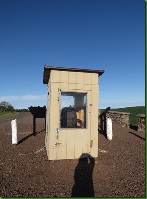
Along one edge of the parking lot is a hut with large glass windows on every side. Inside is an office desk chair. The sign outside tells us that this is the “office” of Brockway Mountain Hawk Watch. A counter sits in this hut from March 15 to June 15, from 8am to 4pm counting spring migrating birds particularly the raptors which go over Brockway mountain as they fly along the Central Migration Flyway. We just missed him or her. That’s too bad.
In 2013, the pay for this position was “no less than $5000” according to the Counter Ad on the website. Part of the job description reads “The count site is beautiful but isolated. Conditions will be cold and windy for the first 6-8 weeks. There is a small “shack” at the site for protection from the elements. The counter will reach the count site by snowmobile for the first month or so. The organizers will provide the snowmobile (and fuel) but the counter will drive it to work each day.”
I suspect they should add “truly dedicated birders, please apply”. I would so love to know about the people who take this job. There is no heat in that building that I could see.
Watching sunset from Brockway Mountain is highly recommended. However the sun sets at just before 10pm up here and that’s too long from now for us to stay up on Brockway Mountain to watch it. We can watch sunset over Lake Superior from right across the campground.
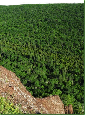
You can take Brockway Mountain Drive all the way across the mountain and end up on M-26 near Eagle Harbor. It’s an 8.8 mile drive and that’s what most people do. But we’re tired so we turn around and go back to Copper Harbor. As we drive back down, we get a great view of both Lake Superior and the town below us although the trees make it difficult to photograph.
I imagine in the 30’s when the drive was put in, the trees were not such a problem since after the mining businesses left off tearing up under the Earth, the logging businesses took over stripping the land. But now, the Earth has done some healing and the people have learned that caring for her is a much better livelihood than destroying her..

Can you see the buildings of the little town?

When we get back, we get busy and David almost doesn’t make it for sunset. The sun is near the horizon as he comes to the end of the little path through the woods to the lake.


By the time the sun has finishes its color display it’s nearly 10:30 but we can’t wait for it to do that tonight. It’s been a long but lovely first day in Copper Harbor. Time for bed. We have more days and sunsets to come.


