August 9 & 10, 2017 Most Recent Posts:
Wednesday and Thursday Bald, Parkman and Gilmore – A Lot More Than We Bargained For
Acadia National Park The Beautiful Thuya Gardens in Bloom
WEDNESDAY

Today it’s Chasm Brook Bridge.
The bus starts picking up at Narrows Too Campground late in the morning for me – 9am. I ride to the Bar Harbor Village Green and take the Jordon Pond bus to the Bubbles Pond Parking Lot where these days only the bus can be. No more parking here, just bus drop off. From the parking lot, red star on the right of the map, I take the carriage road up to Post #7, and make a left to go by the narrow end of Eagle Lake. I’m on my way to Chasm Brook Bridge, gold star on the map.
I pass by Eagle Lake. It’s nice to be hiking along the water even for such a short stretch.

I leave the water and the road continues to rise. 90% of this hike from the parking lot to the bridge is up hill. Of course that means it will be downhill on the way back. YES! The woods are beautiful.
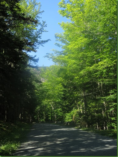
The green all around the little rocky stream I pass really stands out.

Then boy am I surprised to see this green thing on the carriage road.

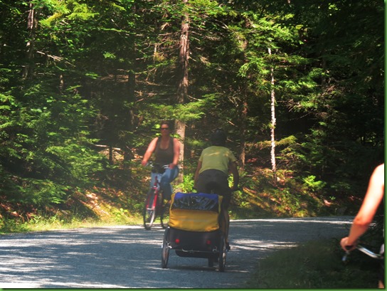
This is more what I’m used to in terms of vehicles here. Lots of folks are out today. It is August and it is now nearly 11 am due to all the buses I had to take and their schedules.
I’ve talked a lot about the signage on the carriage roads this summer and today I’m going to give a better look.
It’s about 2 miles to post #8. At the intersection there are folks conferring about which way to go but I’m all set with my map. I’m making another left turn

From there I carry on and soon come to Post #10. Now this one is really tricky without a map. There are actually three posts. I’ve shown close ups of two of them, 10N and 10S. Take a look and you can see how confusing this is. I suppose it helps to have a superior sense of direction and know for sure which way is North. But again, I have my map so I know where I’m going. Guess which way.

We’ve run into numerous people who didn’t have a clue and without a map were lost until we showed them ours. Some had gone a LONG way out of their way just following the signs. I remember in particular one family with two teen girls who were pretty irritated that their dad had gone the wrong way. They thought they should be at Jordan Pond by now only to discover they still had 2 miles to go. Don’t think the girls were into hiking.


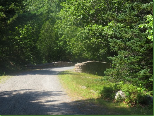
Enough uphill already. After over 3 miles, I’m ready for the bridge. And here it is.

I walk across it, go down on the easy side for a as much of a picture as I can get. Unlike many of the other bridges, this one does not have a sculpted path down and is pretty seriously overgrown.

Back up on the road, I find the date of the bridge. 1926. An oldie.


I get a picture from the other side but there is no easy way down from here either.

While I contemplate what to do next, I check my new hiking app. I forgot my pedometer today which I use to tell how far I’ve hiked. So on the bus I hunted up a phone app to test out and see how it works. I don’t usually carry my phone if David is with me but when he’s not, I do.
Here’s what it tells me and I think it’s pretty acurate. 3.29 miles to the bridge. Took 1 hour 16 minutes and on another page it tells me I’ve done 8157 steps thus far. Nice!


It’s not yet noon and I have plenty of time left so I think since no one is around that I’ll follow what looks like a little unauthorized path up the hill on the far side of the bridge and see what I can see.
What I find is that I can barely see the bridge for all the folliage and it looks pretty rough down there in the stream bed.

I go up a little higher and on to some rocks in what is obviously the stream when it’s running.

I could go on up and see where it goes but I still have to walk the 3 miles back. As I return to the road, I’m a bit surprised to see how high up I am.

I say goodbye to sweet little Chasm Brook Bridge and with that I’ve hiked to all of the Carriage Road Bridges in Acadia National Park.
My route back is the same but on the way I pass other users of the carriage roads.

I pass a trail head to Connor’s Nubble, site of fabulous Berry picking trips this summer.

And I see what that machine is doing driving on the carriage roads.

When I see Rockefeller’s teeth protecting the Eagle Lake shore on my left this time, I know I’m nearly back to the bus stop.

I catch the bus at the Bubble Pond Parking Lot which takes me back to the Bar Harbor Village Green and then I take the bus back to Narrows Too. AND without stopping for ice cream in Bar Harbor.
But that’s only because we’re going out for ice cream with Bill and Nancy tomorrow.
THURSDAY
Here we are, Udder Heaven. We’re only interested in the ice cream but apparently there is Breakfast and BBQ and Lobster as well.

Not sure who was first up to check out the three column menu but I know it wasn’t me.

They don’t have Jamaica Me Crazy so we have to pick something else. That takes a while.

I actually have the same size as David but it looks like more in my cup with a cone on top.

David’s laughing because Bill is trying so hard not to let me take a picture of him and his ice cream. Nancy’s not quite so amused.

We all only have a few more days here at Narrows Too. Bill and Nancy head back south on Saturday and we leave for Seawall Campground the next day. We sure have had fun even if Bill doesn’t want his picture taken.
I LOVE the carriage roads but do think the signage could be simpler;-( Congrats on hiking to all 16 bridges...they are all so beautiful. Thanks for the ice cream photos, I don't have a one with the actual ice cream in it!! OK, you are now ahead of me in the blog catch-up:o)))
ReplyDeleteLovely that you had such a lovely hike on a day I could not be with you. Will be fun to see how accurate your phone app appears when checking elevation at summits, and to compare steps to the OMRON step counters we use all the time. Nice post!
ReplyDeleteYour Bar Harbor and foodie explorations are so thorough !!!
ReplyDeleteNice ice cream reward for celebrating all those bridge visits! :c)
ReplyDeleteA beautiful area to be hiking in. The bridge stands out!
ReplyDeleteI'd have a hard time choosing a flavour of ice cream from that list. It might be easier to just strike ones off the list I wouldn't go for- dark chocolate and watermelon!
Always good to reward yourself with ice cream. There's a great dairy near us here in PA that I'm begging George to take me to soon!
ReplyDeleteWe really enjoyed those old bridges and ice cream is always good:)
ReplyDeleteCongratulations on hiking all the carriage bridges, ice cream is a great reward.
ReplyDeleteNicely done!! All the bridges :) So much sweet goodness in all that ice cream-fun with good friends :)
ReplyDeleteAnother beautiful bridge even if a little smaller. Too bad it was so overgrown below. The ice cream looks so yummy!!
ReplyDeleteLovely hike. I never thought of getting a phone app to track my walks. Can't have ice cream two days in a row?
ReplyDeleteGetting caught up again :-) I have loved every bridge in the park and so appreciate your sharing them with me. Beautiful green rocks along the little creek. I think 452 elevation sounds wonderful!! So what flavors did you end up getting??? Whatever it is, it looks amazing.
ReplyDelete"Bridge Day" -- I like your sense of adventure, and turning those days when you're alone into a quest of your own. It's also really wise that you take your phone with you! Have you found a pedometer that you like? My app on my phone is not accurate and I'm thinking of switching to a pedometer. I love your "Hokey Pokey" turquoise t-shirt. :-))
ReplyDelete