Wednesday May 2, 2018 Most Recent Posts:
Oregon Inlet Campground Love My National Wildlife Refuges
Cape Hatteras National Seashore Bodie Island Lighthouse
Nags Head, North Carolina
I’ve got a big day planned for today so I’m up at dawn and see the full moon in the east as I walk out to the ocean for sunrise.


I zoom in for a fly by so the birds will be big enough to be seen in the picture not just by my eyes. They are headed north. Probably not too far.

As the sun gives more light this group is easier to pick up.

Of course there are the locals who are here every morning and much of the day.

A little closer view.


Even though these are only a fraction of the pictures I took of this gorgeous morning, it’s a lot and I hope you agree with me that there are never too many pictures of the dawning of a new day.

But sun’s up now and the moon is over head. Time to take my long sunrise legs and get them moving on with my day. I do love having long legs.


I’ve packed a lunch and I’m heading down to Hatteras Island for the day. There are a lot of things I want to see including the Cape Hatteras Lighthouse. The Lighthouse is in the town of Buxton on Hatteras Island. Well just outside the town. It’s 40 miles from my campsite and the drive is lovely with the sound on one side and the ocean on the other. This is a really narrow strip of land. I fear for the impact of rising oceans on this area.

With sunrise just after 6am, I was on the road early and had no trouble arriving before the lighthouse opened at 9am. When I pull in, it’s like Déjà vu all over again. If you read my post on Bodie Island Light you’ll know that I first went there and encountered 3 or was it 4 bus loads of kids so I left and came back the next day. Can’t do that here. Too far a drive. So I’ll have to figure out how to deal with these two buses.

I decide I’ll take my time and read all the information boards outside the ticketing area before I go up and see how to get around climbing a lighthouse with busloads of students.
What I learn is very interesting. The current Lighthouse is second lighthouse to protect ships from the dangerous Diamond Shoals off the coast. I borrowed this map from Nc-wreckdiving.com to illustrate the location of Diamond Shoals and the number of ship wrecks. The green oval shoes the Diamond Shoals just at the point that the Outer Banks turn.

The first 90’ lighthhouse to service Hatteras Island was authorized in 1794 and completed in 1802. It was made of sandstone. wasn’t long before it became clear that it really wan’t tall enough to do the job. After decades of complaints, 60 feet were added making it 150 feet tall by 1853.. If you’ve ever been down here you can imagine that after a series of rough storms the two part lighthouse wasn’t faring so well. Construction began on a new lighthouse in 1868 and it was finished in 1870 and the light lit.

It protected the waters off Hatteras Island for over 100 years but by 1990 beach erosion had begun to undermine it. At this point after a century of nor’easters and hurricanes, it was in danger of toppling into the sea.
In 1999, after years of careful planning the lighthouse and all the surroundings buildings were move 1/2 mile over 23 days. My friend Keith came out to watch the move and said it was really amazing. According to the information, the Cape Hatteras Lighthouse is the tallest brick structure in history to ever be moved.
You can drive over to the area of the original site which is now a picnic area. By 2014, the original foundation stones were nearly under water and were moved to the new site to creat an amphitheater near the entrance to the lighthouse area.

The Outer Banks Lighthouse Society engraved the foundation stones with service start date and name of each Lighthouse Keeper. Many of the names are familiar local resident surnames.
I think it’s a great idea and quite moving to walk around and read the names and dates for these corageous families who lived here when it was not a beach resort but rather a lonely long way from anywhere and difficult to get to.

Time now to check about climbing. The ranger tells me to check with the window under the green awning on the right side of the Gift Shop which is not the visitor Center.
When I do, the wonderful young man tells me that he has to assign me a time to climb and suggests 10:00 since all the folks from the buses will be down by then. Terrific! I pay my $4.00 for those over 62, disabled or under 12. All others $8.00. Regardless, I know it will be worth it.

Ticket in hand I walk down the shady lane toward the Lighthouse.

The Main keeper’s Quarters and the Double Assistant Keeper’s quarters were both also moved to this site in 1999. The Double quarters is now the Lighthouse Museum where they have informational exhibits and a virtual climb for those who for whatever reason cannot climb to the top. The Main Keeper’s Quarters is office space.

It’s not 10:00 yet so I head over to the Museum.

The buildings have been moved to the exact same relative location to the lighthouse. Wonderful view from the Double Keepers porch.

I don’t have much time inside before it’s time to head over for my climb. What a beautiful granite base. All the stone came from New England. The base of the “new” 1870 lighthouse was painted red in honor of the original lighthouse which was painted red when it was extended in height to make it more visible at least during the day.

Inside I can see the stairs The wonderful black and white tile floor makes me smile. It’s perfect!

As with the Bodie Island Light you can see how far up you’ve climbed by looking out the windows. Here the windows are open for the breeze protected by wrought iron grille work.

As you are climbing round and round there are two metal rails running from the top to the bottom. These were once the “cage” for the device that enabled the keepers to crank the light turning mechanism. A weight would slowly descend and when it got either to the bottom, if they wanted a long hard crank or part way down, they would crank the handle to pull it back up and keep the light turning. Wish the entire mechanism were still here. Sounds sort of like a grandfather clock.

Up up I go. I can start to see the water in the distance.


Is this an encouraging sign??


As I near the top, I have views of the wetlands, the sound, the town of Buxton and the Ocean.


Last window, up the enclosed stairs and I’ll be at the balcony.

And when I get there, the friendly ranger is waiting for me. There is unfortunately no access to see the light from inside the lighthouse. I’m not sure where the door for the keepers to access it is. I don’t see it.

We chat as she tells me other places she’s been as a seasonal ranger and I tell her about my friend Gaelyn whose been at the North Rim for many years.

It’s a more windy day today than it was when I visited Bodie Island Light but the views are terrific.

It’s wonderful that the National Park Service owns so much of the southern section of the Outer Banks and we can see how wooded it actually was when the first English settlers stumbled on it and then disappeared.

I’m not sure if the town of Buxton could really be called a fishing village any more with all the vacation homes and seasonal residents.

Proof that I was here, proof that it was windy and blowing from the South.

I sure wish there was a closer view of the first order Fresnel Lens that still shines out every night.


Heading down I find some folks on their way up taking a break.

I notice on my way down that at a certain point, the walls have been recently painted. I didn’t notice that on the way up. Wonder when they do the painting?

As I leave I notice the line is starting to form for the next group up. Each group has a start time in order to control the number of people in the lighthouse at one time although they allow you to stay as long as you like.

I head back to the museum where I watch the Virtual Climb film now that I’ve done the real climb. Didn’t want to spoil it for myself. Sort of like I read the book before I see the movie.
The film is excellent even for those who have climbed. The narrator who is being filmed climbing shows you pretty much everything I saw and throws in a lot of interesting information.
The museum is chock full of even more details. I spent nearly 2 hours reading about all the amazing history. Here’s a tiny bit of it.

The light ships which marked the sandbars and turbulent currents have been driven ashore by storms, sunk by German U Boats in WWII and were finally replaced by the Diamond Shoals light station was put further out.
The light station history is very interesting and can be found here on its web page and on its facebook page. The map also shows the location of the wreck of the warship Monitor which was the first iron clad warship commissioned by the Union Navy during the Civil War.
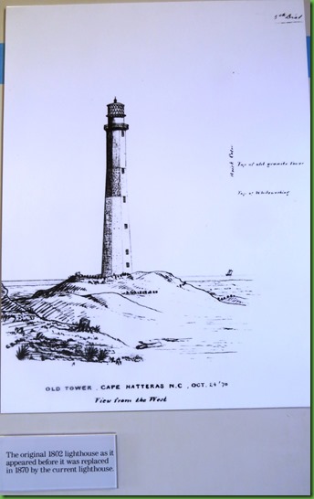
A drawing of the original 1802 Hatteras Light House. Made of sandstone with a lamp powered by whale oil. The map shows the location of the 1803 lighthouse which is clearly under water now. It also shows the 1871 lighthouse location as of 1980. That too is underwater now.
The shore line map below is also interesting. The blue line represents the shore in 1872. The gold line is 1917. Given that the shoreline has eroded even further in the 38 years since this drawing (sure wish they would update this), I wonder how long before the narrow strip of land which now connects Buxton with Avon is completely gone and Hatteras is truly an island.

Just for fun, here are some pictures of some early roads on Hatteras. At first they were wooden plank.

If you weren’t careful to stay on the roads you might end up like this.

Storms in the area were legion and people lost their homes frequently. This of course was when rebuilding was at your expense not via government subsidized insurance for beach front property.

 Among the most interesting information was about the key roll the Outer Banks played in the Union Victory in the Civil War and the unique protection of the Outer Banks in WW II.
I had no idea that U Boats were off the coast and sending spys on to the shore. By 1942, there were 19 U Boats operating off our coasts. One evening in 1942 five of our ships attempting to supply the British were sunk, during March and April almost one ship a day went to the bottom. Thus this area is known as the Graveyard of the Atlantic.
Paul Dahl missed his chance to be one of the Coast Guard on horse back patrolling these shores in the 1940’s. I wonder if his father, like his son, was in the Coast Guard and might have been here.
I spent a wonderful morning at the Cape Hatteras Light House and Museum from 9am, when they opened, until nearly noon.
If you come to this area, be sure to visit and leave plenty of time for all there is to see and learn. Unfortunately for me I didn’t know there was a full moon climb here on the 29th of April and thus, even though I was in the area, I didn’t come down for it. DARN! I’ll be gone by the next full moon. But thanks SO much to Suzanne for commenting and advising me to do it. Wish I’d known sooner. But if you come, now you know.
Hi, Sherry. Sorry I didn't get the info to you in time for the full moon hike. But here is a little good news if you are still in the area...you didn't miss the Fresnel lens! It was damaged by vandals, so they replaced it with an aerobeacon. The original lens is on display in the Graveyard of the Atlantic museum.
ReplyDeleteInteresting to see what they did with the base of the old lighthouse. It was still in place (very close to the water's edge) when I was there in 2013.
Beautiful photos of one of my favorite subjects! Glad you were able to wait out the busloads. They seem to be everywhere these days.
Suzanne
Always love lighthouse pictures and visits! My favorites are the striped ones.
ReplyDeleteWe have been there and it is just beautiful. So glad they were able to move it and preserve it!! You photos are wonderful...good memories:o))
ReplyDeleteSo nice that you have the time to relax and really enjoy everything in such depth. Loved the pictures of the climb.
ReplyDeleteGreat tour. Hatteras is one of my favorite lighthouses with its amazing history.
ReplyDeleteYour sunrise pictures are breathtaking. The lighthouse is great
ReplyDeleteSmart move to wait until the busloads of kids cleared out before you made your ascent up into the lighthouse! Noisy kids + confined spaces do not make a good combination. The lighthouses on the east coast look so different from the west coast. I can't wait to see them for myself! I love the black and white tile floor and your shot into the lighthouse framing the spiral staircase. So interesting to see the historic photo of the "roads" on the beach and the coastguard patrol on horseback.
ReplyDeleteWe visited the Hatteras Lighthouse a few years ago before we fulltimed and enjoyed it. Wish we could have been there to see it moved, what a pucker factor that must have been for the movers.
ReplyDeleteI rode plenty of horses in my Coast Guard days. Unfortunately they were all contained inside engines... :cD
Always love your sunrise pictures since I am too lazy to ever see one!@!#? I guess you got a lot of your steps in for the day by climbing to the top of the lighthouse! Great views. I did see the Fresnel lens at the museum. xxxooo
ReplyDeleteThanks for this, Sherry. I appreciate your comment about the lighthouse keepers and the lives they led when the area was less populated. I visited the light house at Point Reyes in CA several years ago. It's isolated now, of course, because it's in a park but I couldn't help thinking of how lonely it had to have been to live there. We drove for miles to get to it. I like privacy, but that took a special person/people to do that job or be married to someone doing that job. Love the view from a light house ... not sure that I would have enjoyed the life as much as the view! Thanks for jogging my memory of that visit.
ReplyDeleteJust lost a nice long comment to where I don't know, but I will try to repeat it here. I love your continued appreciation for sunrise & sunset & the great pictures. It reflects your enduring love of natural and appreciating everything in a new day from beginning to end - not somerthing to take for granted - ever. So glad you can climb these lighthoise steps and hope I will again someday. When I saw your pictures of the turning mechanism in the lighthouse that allowed them to turn the lens from down below it made me wonder why they never had a pulley system in that central area to haul the heavy lamp oil up.
ReplyDeleteI am so glad you get out for sunrises and share their beauty. I haven't seen any east coast lighthouses so your tours are great, especially without two bus loads of kids.
ReplyDeleteVery interesting post. Enjoyed it.
ReplyDeleteLove your early birds and that gorgeous sunrise. Yes I agree there are never too many pics of a new day!! Glad you were able to time your lighthouse climb to have the place to yourself - what a treat!! Thanks for taking on all those stairs so I could see the amazing view. That's a lot of greenery between the light and the water!
ReplyDeleteI would love to see that lighthouse for myself someday. Beautiful shots!
ReplyDeleteIt was extremely crowded when we went to the lighthouse, so we skipped the ascent. Instead, we wallked over to the site of the old lighthouse and wandered around the beach there since there were lots fewer people.
ReplyDeleteGorgeous sunrise/bird pictures!! Glad you got to climb in peace and see such views. What a history! Lighthouses are really neat.
ReplyDelete