Sunday April 6-Tuesday April 8, 2014
Suwannee River State Park, Live Oak Florida
SUNDAY
Today is our last day at St. George Island State Park. It is cloudy and cool and of course over cast. No visible sunrise. Even so, hope springs eternal, and I go down to the beach but in less than 2 hours the wind is too strong and I am too cold to stay even with a sweatshirt on. For fear of sand which I believe was the demise of my previous camera I do not take my new one. I have to get a good case for it before I’m willing to take it to the beach if I intend to stay for a while rather than than just walk on the beach.
So instead I work on the blog, do some reading and begin packing up for our move tomorrow. Sort of an anticlimactic end to our two weeks stay here. Actually I have been very surprised that it has rained so much over this time and it hasn’t really been warm enough to tempt me into the water for a swim. But we’ve had a wonderful time anyway and will definitely return to St. George again.
MONDAY
Today was to be moving day. Today was predicted to be 90% chance of rain. Today was predicted to have 20+ mph winds.
I don’t like moving on a rainy day. I like moving in 20+ mph winds even less. Most of this was predicted for the early afternoon so we are up and out and on the road by 9am which is quite unusual for us. Tanks dumped, dolly on RV, car on Dolly and driving out of the park by 9am.
David and I have two different time tables and since he likes to drive we seem to go with his which gets us out around 11am and not to our destination until after 3.
I keep checking for the rain, for the winds. The day is fine as we drive about 80 miles into Tallahassee and stop for a food pantry fill up at Whole Foods and for lunch. With a big hole in the wallet, we drive on another 75 miles to Suwannee River State Park. In spite of our early start, with our stops, we still pull into the campground at about 3:00.
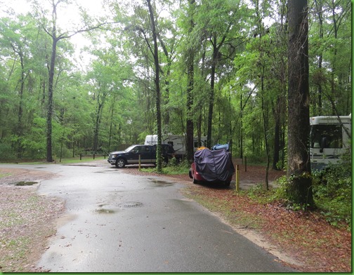
What a cute little park! It has a 30 site campground in among the trees. Really lovely. All the sites are a nice size. Some of them closer together than others. My favorites are #11, #20 and our site #15. There is a new bathhouse and amazingly at what seems like an older campground, it has full hook ups and a laundry.
The extra jackpot is that the park is right on the river and has an easy boat ramp.
We don’t get to look around much since the rain starts just as we are finishing setting up. It starts out lightly but by the time for the men’s national championship basketball game at 9:00 it is pounding on Winnona’s roof making it hard to hear the game. YES, we have CBS this time.
BUT, they have also announced a tornado watch at 4:00 so we are keeping our eyes on the banner scrolling across the screen and continually seeing that the warning for our county, Suwannee, is still in effect.
I promised myself after spending 2 evenings in bathhouses and one in the basement of the restaurant in Cumberland Mountain State Park in order to allude 3 different tornados in April and May on our 2011 Western Trip, that I would not be anywhere near Tornado country in April or May again. Especially after Ruby received some serious hail damage in Oklahoma. So it was great to have the basketball game to keep my mind off the tornado watch.
Thankfully the tornado watch goes off at 11pm and all we have is torrential rains all night long. I expect to wake up with Lake Side Property again as we did in St. George. But the ground has soaked it all up. I find that amazing given the amount of rain. Really it poured buckets.
TUESDAY
I know Monday is “wash day, everybody happy???…” and all that but I was busy moving on Monday.
So this morning I do 3 loads of much needed laundry. I really love when a park has laundry facilities and I don’t have to go out to a laundromat and hang out for half the day.
Here there is one washer, fairly new, and one dryer whose outside is very rusted so you can’t fold your clothes on top of it. $1.50 for a nice 30 minute wash in a good size machine. I was quite excited at $1.00 to dry until I found that too was 30 minutes and even on the highest heat, it took two cycles to dry each load and some things still weren’t dry.
After running back and forth 6 times to the bath house there were 3 sheets, some flannel pajamas (yes I wear these in Florida in the Winter) a few sox and the one pair of jeans that were not dry. David puts up a rope from the RV ladder to the campsite pole and hangs them out. Not much chance in this nearly 100% humidity that they will dry but hey what else can we do with them?
After that we don’t have enough time for a good paddle so we set out to explore the park, check out the boat launch for tomorrow and do some hiking.
The park has a really nice picnic area on a bluff over the river. There are 3 swings overlooking the river. No one is in them today but it’s a really nice touch I think.
I can see from here the river is definitely up and moving although not as much as I would have expected. But then this is the usually slow and languid Suwannee.
At the boat ramp, the river is climbing up the ramp but a couple who put in and paddle up the river report later that they had no trouble at all. Sounds good for tomorrow.
There are several trails that take off from either side of the boat ramp and walk along the river in both directions. We take the Suwannee River Trail – catchy name - which is supposed to lead us along the river to the Balance Rock Trail and then to the Lime Sink run Trail.
At the beginning of the river trail is a tree that definitely needs a hug and the flood stick marking how high the water has gone in 8 floods since "the big one” in 1948. It’s pretty impressive. Nearly the entire park must have been flooded in at least 3 or 4 of these.
The pole has 8 floods marked on it including 2009 which is third from the top. WAY over David’s head. For some reason that flood is not on the sign which gives the heights. But I can see from looking at the ones before and after that date that the flood then was somewhere around 64.5 feet. Amazing! Also amazing to me is that only one of these didn’t’ take place in February March or April. April is the most popular month for flooding apparently. And here I had been told that the rainy season was in the summer.
We walk along the river trail up to the balance rock where the depth of the river is more noticeable. The rock is described as a “massive outcropping roaching over 20’ high”.
Today it is not looking quite so “massive” at about half mass and height. The height of the river is very noticeable here. We’re guessing that more than half of the rock is under water.
I’m thinking you may not even be able to paddle around it under “normal” conditions. The shore may well come up to its base. If so, you wouldn’t be able to paddle around it like you might be able to do now. And what is it “balanced” on? Can’t see today.
This is the “upriver side”
While I am putting this post together, curiosity gets the better of me and I go on line to see if I can find pictures of the rock in non flood times. Of course I strike it rich and am vindicated in both my suppositions,
I can see here that we are only looking at the very top section of the rock.
Looks like time and water have done some work on the rock. It looks even more “massive” in this 1923 photo.
At this point we are at the end of the Balance Rock Trail and turn to go over to the Lime Sink Run Trail. The sign has clearly had some hard times.
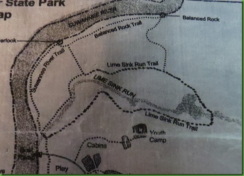
From this map you can see where we have gone. We start out at the Boat Ramp in the lower left corner and take the Suwannee River trail along the river up to the Balanced Rock Trail to Balance Rock and now we are headed over to the Lime Sink Run Trail.
We are hoping tomorrow morning to put in at the boat dock and kayak up the River and the Lime Sink Run which you can see in the middle of the Trail. It looks like my kind of place.
The connector trail takes us to the middle of one side of the Lime Sink Run Trail so at some point I want to see the area we miss. What we see is lovely and wooded although we do encounter a few mosquitoes. I’d almost forgotten about them but with all this flooding I shouldn’t be surprised to see them again. We get glimpses of the run and then we come to the bridge over it.
Having not seen the run during “normal” times we don’t realize how flooded it is until we see the bridge. The water is over it on one end and up to the very top in all but the middle.
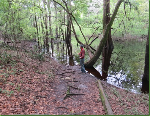
Ok so how do we get across it without putting our feet calf deep in water and having to walk out with squishy shoes? This isn’t a slough walk. Or it wasn’t supposed to be.
Problem solved, I stop to take a picture of our climb out from the bridge.
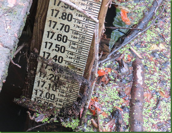
Then I see the water depth indicator along the side and go back to see what it says. Compared to a 64 foot flood this isn’t much at 17 feet but it’s probably going to cover the bridge by tomorrow and no one will be able to take this hike. Glad we did it today.
A lot of non cypress trees are standing way out in the water. I wonder what effect this will have on them? I also wonder if there is some sort of flooding every year here. Good question for a Ranger. In the big scheme of things this one is clearly small potatoes. But it looks pretty outrageous from here.
On down the trail we go until……………….it walks right into the water.
Now what??
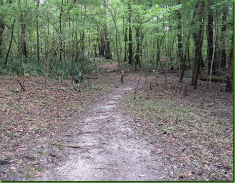
We start overland staying just above the water level hoping we will be able to find the trail again at some point.
We finally see one of the trail markers out in the water. They are numbered and this one is about 4 away from the number we saw on dry land, #33. So clearly 3 others are out there completely under water at this point. Boy the run is really over its banks. Having not seen it before, we had no idea how much.
A little further on we see what might be a trail coming out of the water. Could this be it?
Yup, there’s the next yellow marker. Good plan, paid off!
Even the palmetto are under water. I wonder how they like that and how long it will be before their feet are dry again? It’s been a very surprising hike and interesting in a way it would not have been if it were not for the flood.
We will need to come back and see the area when the water is down.
Tomorrow I want to get out on the river and experience it when it is up.
Let’s just hope there is no more rain!









I agree, the first heavy rain at this time of year does change everything. After it stopped I was surrounded by color as the dogwoods and azaleas bloomed and the trees turned green (so did my truck).
ReplyDeleteI enjoyed this hike very much. I'll be interested to see how fast the water retreats. I have to go back and re-read--I didn't see the name of the campground. It looks like a great place. I don't have to tell you and David to enjoy your stay--that's a given. :)
In November we launched at Spirit of Suwannee Music Park, paddled to Holton Creek River Camp for an overnight stay, and ended the next day at Suwannee River State Park. The river was much, much lower then...your pictures surprised me!
ReplyDeleteThere are many fresh springs that feed into the Suwannee. I hope you're able to find some of them. The neatest one fed out through a cave in the limestone. We got into it and explored despite the cold and wind we had to deal with. It was completely amazing and magical!
The winds stopped here overnight, and today was just gorgeous. Maybe it will reach you by tomorrow.
ReplyDeleteLove David's "Now What?" expression!
ReplyDeleteXXXOOO
Those high water marks just go to prove it's not nice to fool with Mother Nature. ;c)
ReplyDeleteI'm so glad we have our washer/dryer in our MH. Sorry you had so much trouble doing the laundry, a washer/dryer was #1 must have when we were shopping for our MH.
Good luck in your paddling, that is a really nice launch area. Just don't get swept away with all that high water! :cO
I'm hoping that we have clear travels across the southeast well away from any tornado activity when we leave. My mad dash across Green River Lake to the office basement back in December was enough fun for me (and Casey!). It looks like a nice campground; we were on the Suwanee River back in 2012 when we camphosted at Otter Springs.
ReplyDeleteDavid's "Now What?" expression is hilarious! Wow, that is some seriously high water. But not enough to deter you two intrepid hikers!
ReplyDeleteJust look at all the 'new' green leaves on those trees!!! Spring!! Certainly in a different area from the last couple of blog pictures and the sea and sand...
ReplyDeleteGlad they got a new bath house. The old one was scary.
ReplyDeleteAs you know, I love all your posts, but my favorites are ones where you are exploring a new park and/or exploring places we've been. We've been to this state park - not camping, of course, but we always checked out campgrounds (for future use??) and I remember this one well. Hope you get to revisit this trail when water is lower. Will be fun to compare pics.
ReplyDeleteRain really does change everything and when you get as much as we had this winter, the rivers are way up!!! We left Suwannee on March 31 and Balance Rock was half as visible as in your photos;o(( Hope you get to kayak. We were shut out as the river was flowing at over 8 mph....be careful!!
ReplyDeleteWe're amazed about Florida's weather. That same day you got the torrential rains, we had a brief shower, and that was it! I think all that rain helps bring out the no seeums too. Got a few bites on me now :)
ReplyDeleteThis certainly has been a rainy winter. Too bad we can't ship some of this rain out west.
ReplyDeleteYou are in one of our favorite state parks. It was less than 100 miles from where we lived in south Georgia.
ReplyDeleteWe went there several times in September of 09.
The northern part of the state gets a lot of rain in the winter months, from the remnants from the cold fronts moving south east through the country. The further north you are in Florida the wetter it is in the winter months. I'm not at all surprised the flooding is so often during the winter. The panhandle gets it even worse.
I remember balanced rock well and went back to my blogs from Sept of 09. If I remember correctly, we walked right up next to it. check out this blog post. http://florida-georgiacamping.blogspot.com/2009/09/suwannee-river-state-park_14.html and compare my pictures from back then. It was on the bank of the river then...not in the middle like it is now. Very interesting to see the differences.
There was an old railroad bridge in the area we found on our hikes. We were told it would often be underwater when the river was up. I'd be interested in how it looks now. It was a cool place to walk. I hope you can find it and get some pictures.
Watch out for those jumping sturgeon when you're kayaking. They have been known to jump into boats and injure people!
Looking forward to more posts from one of our favorite parks.
ohhhh nice campground! I like that kind of trail … all along the water Hahaa a tree that definitely needs a hug … just warms my cockles that you two love trees… I truly thought I was the only goose that hugged trees…
ReplyDeletenot too fond of trails that end in the water … nor bridges ~ beautiful walk even in the damp … it's beautiful ..
Yes, you are in a very nice park. Looks like they've made lots of improvements in the campground since we were there many years ago. Hope you get out on the river.
ReplyDeleteGlad you didn't let a little thing like a flooded trail deter you from continuing on. If I get lost in the wilderness I want you to look for me - you'll find my trail!
ReplyDeleteI love how you enjoy every aspect of the journey. . .lovely!
ReplyDeleteThat looks like a sweet little campground........and FHU too! Jackpot! Hope the kayaking pans out for you and the rains stay away for awhile!
ReplyDeleteInteresting to see some flood conditions as long as you're not overly affected. But I'm thinking that fence is what I saw almost under water in a later post. I seem to be way out of order trying to catch up.
ReplyDelete