Wednesday June 18, 2014
Munising Tourist Park Campground
Munising, Michigan
Let the challenge continue.
We’re out pretty early this morning. We have to get a jump on all these falls. As we are driving to the first one we see one of the Munising Bay Range Lights so we stop for some pictures. We read the information which describes where the second light is but when we go there, not too far away, we can’t find it. How can we not see something as big as a range light? Especially since our information says they are still in use.
Oh well, our waterfalls are waiting.
The first one, Alger Falls, is another located right on the main road. Actually at the intersection of two main roads, M-28 and M-94 to the west of town. I’m sure it is often missed as people zoom by in their cars since it is slightly hidden in the trees. Still I feel sorry for it not having a lovely canyon or even a secluded spot to call its own. The sun is shining in just the wrong place for good pictures of it.
Our second falls of the day is just a short distance from Alger Falls.
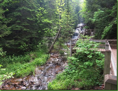
This one is not so easy to miss given the sign. We go down M-94 and take a short path to the viewing platform where Wagner Creek flows over numerous rock ledges to form beautiful Wagner Falls.
Our information tells us that in 1895 Clotilda (Tilly) Wagner took out a homestead on 40 acres that included the small stream and waterfalls then known as Silver Falls. There is no indication that the homestead was actually ever farmed. It seems to have been a vacation retreat for her, her friends and her father who was an early settler of Marquette arriving in 1853 at age 19. He went on to become a state senator.
On the way we pass a stand of these lovely yellow wildflowers shining out in the dappled sunlight. When we got back I looked on line through the Michigan wildflowers and cannot find it. Can anyone identify them for me?
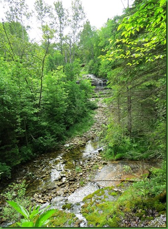
Wagner Creek’s numerous little cascades babble alongside the trail.
The falls itself is a 20’ cascade, just the largest of a series that flow down the creek on its way to Lake Superior.
We are on a roll here!
On we drive down M-94 to bag our third waterfall of the day before noon. We’re on a roll.
Sandwiched between a dam and a powerhouse the water flow of Au Train stair step falls varies. You already know how I feel about damming the rivers so I won’t repeat my rant here. I’ve excluded all the powerhouse and dam pictures from my memory. The falls are beautiful and deserve to be left in their natural setting and unregulated.
The sandstone walls along side the road leading up to the falls and all its apparatus are really gorgeous especially with the water dripping off of them.
There are actually two falls at Au Train. We went to the end of the road and walked beyond the gate to the powerhouse and the lower falls seen above. On our way out we stop at the upper parking lot where we were told we could see the upper falls. We imagined there would be a trail but if there was we sure couldn’t find it so we walked down through the woods until we could see the even more stair stepped upper falls through the trees. Love the zoom lens on this camera.
And now for our biggest falls challenge for today.
We head off in search of the Rock River Falls located within Rock River Canyon Wilderness Area. The 20 foot cascading waterfall is located within a secluded area of Alger County. This quote from the waterfall brochure just adds to the quest. “The falls is located 3/4 mile from the parking area and this waterfall is truly for the adventurous”.
It’s quite a distance away. We travel 21 miles down M-94 to the town of Chatham, one bar and one farmer’s co-op. From there we take Rock River Road which shortly turns to dirt.
We travel 3 or 4 miles down that road, Turn left for 3.5 miles on a smaller dirt road, turn left again and travel a mile on an even smaller two track dirt road to the parking area.
Poor little low to the ground Ruby is being a champ about this.
When we get to the “parking area”, there are no signs for a trail or waterfall.. Nothing but “this is a wilderness signs”. There are two trails. Which one?
Well one is actually an extension of the road but hardly looks drivable. The other looks more like a trail so we head out down it.
I check my pedometer so I’ll know when we’ve gone 3/4 of a mile. Bug gear is in order here in the wilderness.
We walk and we walk and the path gets smaller and smaller.
When it starts getting muddy I think we must be close but I don’t hear any water at all.
I check my pedometer. We’ve gone more than a mile. No sign of any waterfall. Not even the noise of any stream. This must be the wrong trail. SIGH…………. We head back.
We walk down the road into the no can drive area.
Here’s what we find very shortly at the end of the road. It’s beautiful but there is no trail through it.
We back track. David sees orange tags hanging from trees that seem to indicate a trail. We follow the first 4 but it is clear that it goes deeper into somewhere that is not a waterfall.
But isn’t it wonderful to have hours to search for a waterfall even if you don’t find it?
Well either we were on the wrong trail or more likely the directions were wrong and the distance to the falls from the parking area was not 3/4 of a mile but something more than a mile and 2/10. If I had even heard water I’d have kept going. When we get back to a black topped road and I have a phone signal I call the VC and ask if anyone knows about the trail to this waterfall. The woman who answers the phone says yes she’s hiked it. I explain what we’ve done and after repeatedly describing our following of their directions she says well she doesn’t know if we were on the right trail and it might be more than 3/4 of a mile or more than a mile or, well she’s not sure. I admit defeat and hang up.
So after coming this far and hiking about 2.5 miles we come up empty handed. We will not get 100% on this challenge. We have failed to find the Rock River Falls.
Miner’s Castle has a waterfall AND a beach.
We back track all the way down the dirt roads and the miles back to Winnona. Time to take care of a few things and have an early, ie 4:00, dinner. It doesn’t get dark around here until about 10:30 at night now which is tough on those of us who like to get up early. But after dinner we figure we have at least a few more hours to check out the Miner’s Castle area from a spot closer than sand beach was yesterday.
Ruby takes us the two miles into town and then the 4 miles out Highway H58 and then 6 miles up Miner’s Castle Road down to the lake shore.
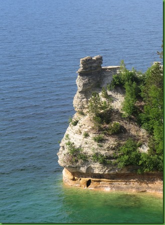
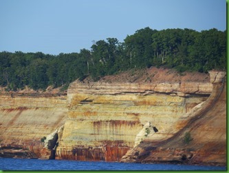
At this point we are standing on top of the dramatic cliffs that are the actual “Pictured Rocks”. They say the best views of the rocks and Miner’s Castle are from the water but we think these taken from above and behind are pretty good too.
Boy do I love the zoom on this Canon SX50! Check out these close ups of this scene.
It isn't often that my attention gets distracted from a beach.
From here we go down to Miner’s Beach to see what we can see.
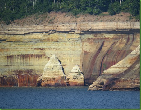
Here’s more of what we can see. Just look at the painted pictured rocks. This is exactly what they looked like on this blue sky day.
Have I said how much I like the zoom on this camera?
Back at the beach, there is a little inland lake which must be very nice for swimming since I assume it would be much warmer than Lake superior. Although I am also sure that it is temporary depending on the wave action keeping or eliminating its dam against the lake.
We had intended to check Miner’s Falls off of our list but we spend too long ogling the pictured rocks. at the Beach and enjoying the castle. So we save it for another day.
Back on the home front…..
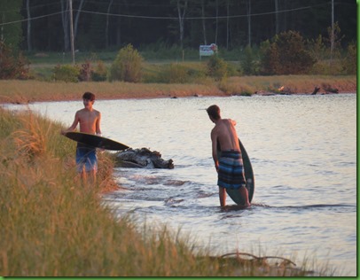
We are back home by sunset in time to see two young boys skim boarding on the shore and in the water. It is 46 degrees outside. I’m dressed in winter clothing, they are in swimming suits in that freezing lake water. Ah youth. I think their Michigan blood must be way different from mine.
The sun is a beautiful blaze of orange as it sets over Lake Superior.
I have loved this view from my tent in any of those many many years we were tent campers.
I love having scenes like these in my backyard every night.
















Thanks for those waterfall pics. They are refreshing after being in the desert for two months :)
ReplyDeleteBummer you weren't able to finish the challenge. I do think you got plenty of exercise for the day though :) You've tired me out. I think I need to go back to bed for a nap :)
ReplyDeleteThose rock formations are beautiful and you took great pics. Just another thing to add to our UP trip, thanks.
ReplyDeletewhat beautiful falls and cliffs and pics of them!
ReplyDeleteMaggie
Your new camera is doing a fine job! Love the rocky coastline. So much more interesting than the flat sandy Florida beaches.
ReplyDeleteSorry you couldn't find the falls. I hate when the signs are so bad. Do you use the map feature on your phone? We use ours all the time and it often helps us find something we're looking for.
ReplyDelete46 degrees and they are in the water....whew that must have been cold. I guess their summers are short so they need to enjoy them while they can.
I love my Canon Sx50 too. The zoom is definitely amazing. I rarely take photos without at least a little zoom.
Those waterfalls remind me so much of the ones we find in the Ga mountains.
The Painted Rocks are beautiful and a sweet reward after the missed falls. I'm still in awe at the diversity of that area - even the changing colors of the sunsets is amazing. Thank you for all the work you put into the photos and narrative, I enjoy every bit of it.
ReplyDeleteLove the waterfalls....all waterfalls. Gorgeous sunsets too.
ReplyDeleteWhat is it that makes waterfalls so refreshing? And even though you didn't find all of them, you still got more accomplished than the average person.
ReplyDeleteYour camera is amazing, I have to check one out. I like the pocket sized point and shoot cameras, but the lenses get so dirty too easily and leave spots on my pictures. And no way to clean the dust off the inside of the lenses without a repair that costs more than a new camera. :c(
What a beautiful area. I'm now reading the journal of a young man who backpacked the entire North Country Trail (NCT) last year, and his description of the mosquitos in that area comes very close to yours. I don't know if I could deal with them, and would probably have to visit the area in the off season for bugs!
ReplyDeleteThe yellow flowers are Clintonia. You should also be seeing Bunchberry, a tiny cousin of the more familiar Large-Flowered Dogwood. In keeping with your quest for Waterfalls, consider stopping overnight or so at Pattison State Park in Wisconsin. Boy...wait til you get to Minnesota :)
ReplyDeleteRandy from Minnesota
Randy thanks so much for all your recent comments, for the flower ids and for the recommendation. We could use some for Minnesota. Itasca is the only set thing on our agenda and Tamarac NWR. We would love to do some kayaking in the Boundary Waters and Voyageurs National Park.
DeleteIf you want nice scenery, once hitting Duluth head Northeast up Highway 61 to Tettegouche State Park for a couple nights. There is so much to see there; falls, Palisade head, Shovel point, Lake Micmac. You will be happy camper.
DeleteAfter Tettegouche, you can head up to Grand Marais to the Municipal Campground passing multiple falls on the way, Cascade State Park, in my opinion, has the most photogenic.. Grand Marais is known as the starting point of Gunflint Trail and provides access to the eastern half of the BWCA. If you travel the full 50 miles you will witness nature's full fury, a huge swath of timber absolutely flattened by a wind storm about 5 years ago as well as the resulting Forest fire a couple years later.
You will then want to backtrack to the turn off to Isabella and follow the road to Ely. Two campgrounds in the area are appropriate for RV's; Fall Lake in the Superior National Forest and Bearhead Lake State Park. Ely is the gateway to the western BWCA and is all things canoeing. From Ely it should be an easy journey to Voyageurs, check conditions before you go. Minnesota is suffering from historic flooding, including International Falls (Frostbite Falls, if you are a Bullwinkle fan)
Randy from Mn (land of 10,000 lakes and then some)
This is Great Randy. We'll see how we can fit some of this in. Is it STILL raining there? David asks whether "historic flooding" means more mosquitoes. :-)
DeleteLove the waterfalls. You've probably been there, but the drive along the Columbia River on the Oregon side has some beautiful waterfalls--9 or 10 of them, I think. Rich and I made it our goal one year to see them all. I think it's fun to set goals like you do. I read another blog the other day where someone's goal was to see wooden bridges. Our goals, had we been able to continue to do them, were going to be light houses and wooden silos. We did get to see every lighthouse on the Oregon coast--one, Terrible Tilly, from afar on a clear day.
ReplyDeleteSherry, your new camera is a WINNER!!! Your photos of “Pictured Rocks" are amazing. So you really have gotten one of those "Binocular" cameras:o)) Keep taking us to all the waterfalls it makes us feel so much cooler!!
ReplyDeleteWell, these are the times when we tell ourselves, "It's the journey, not the destination." Looks like you guys had a heck of a journey there! Mother Nature's beautiful palate...
ReplyDeleteGreat pictured rocks pictures :) Too bad you didn't find Rock River Falls. Part of the adventure is the journey, right? :) Beautiful other falls you did see and a gorgeous sunset! Clotilda was her name? Oh poor dear...
ReplyDeleteMy favorite line in this post is the one about having the time to explore even if it doesn't pan out exactly the way you planned. Great feeling, isn't it? Please know that David's energy and the pictures of him continue to be an amazing source of encouragement for Bill. As you well know, recovery seems so slow when you are in the midst of it.
ReplyDeleteYour second post on the waterfalls didn't disappoint! So sorry after your efforts that you didn't make it to the last one :( Love the pictured rocks. There is something about water that does it for me, whether it be lake or ocean!
ReplyDeleteThat is so discouraging when you can't locate something you KNOW is out there!! We've had many hikes like that. But part of the adventure is the search:) You sure gave it a good try. You had great success and beauty in all the other falls you found, for sure. Great job:)
ReplyDeletePictured Rocks and Miner's Castle are gorgeous. That first photo from the cliff with the coast and blue water is so pretty. Glad you had that zoom:)
Yes, youth must have a different internal temp than us. Our neighbor's daughter had a party the other night. I had to come in about 7:30 because I was so cold and the girls were all swimming off a raft and lying on tubes being pulled around behind the boat. No wet suits, either. Of course, they were around 11, 12 years old. They didn't even look cold! I don't get it!
I agree -- it's wonderful to have hours to search for a waterfall (in a beautiful location) even if you don't find it. As others have said, it's the journey, not the destination. And you two do such a wonderful job of enjoying and describing the journey!
ReplyDeleteIs that you Maggie? Well we would have done much better to have searched for this than to use the directions from the VC. We would have gone 2 miles rather than a little over one searching for it. Thanks! We'll use this "next time".
ReplyDeleteWow, you guys rocked! Even if you missed one waterfall, those pictured rocks are quite amazing. I don't know if I can even entice Steve to do this challenge, he is not crazy as I about seeing these beautiful cascading waters. I wonder what the weather is like when we get there in August, it could be people and mosquitoes that we will deal with.
ReplyDeleteBeing retired and having time is such a wonderful thing, then being able to travel and explore like this is truly icing on the cake! We are so fortunate!
ReplyDeleteWhat a lovely, lovely area you are in. Thank you so much for taking us there!
Very pretty! A friend of mine is taking a photography class in taking photos of waterfalls. Yes the zoom on your camera is great. Ok, so tell me, do you take a ton of photos and have to delete a bunch because they are not in focus? Granted you are not taking pictures of things that move (like dogs). I probably delete half of the pictures I take.
ReplyDelete