Sunday July 13, 2014
Bear Paw Campground
Itasca State Park, Minnesota
Yesterday we successfully avoided the crowds by seeking out a small lake rather than the main for a kayaking afternoon. We had the lake all to ourselves and had a great experience seeing grouse, loons and beaver lodges.
Today we thought that if we got out on the trails by 7am, we would be the only folks out and about. It worked.
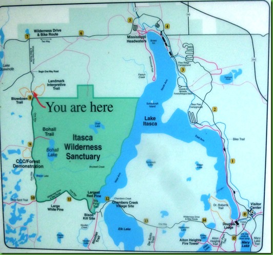
The park’s Wilderness Drive is a very popular spot in Itasca. It is also the trailhead for 9 trails ranging in size from 250 feet one way to 3.8 miles one way. The drive is 17 miles all the way around from #0 to #15 on the map above.
We start out at #2 Bear Paw Campground located on the East Arm of Lake Itasca. We should have bought the little guidebook for $.75 when we were at the visitor center the first day we got here but, we didn’t and none of the centers is open this early in the morning so we’ll just wing it. But take note from our oversight when you come here.
We stop at the Headwaters (#5) first in order to get the obligatory picture but without the normal crowds. We are surprised to find a fisherman but I guess just after 7:00 isn’t early for him. The sun is not cooperative at all. We don’t stay long here or we’ll lose our edge on the Wilderness Drive crowd. We hope to bike the trail from the campground up to the Headwaters and give this great spot the amount of time it deserves, perhaps tomorrow. I’ll put our headwaters pictures in then.
Our next stop is at #7 the trailhead for the Landmark and Blowdown Interpretive Trails neither of which is on this list to the right which. This is also the spot where a 4 sided kiosk tells you all about the Wilderness Drive. It provides this list of the hikes on the drive with the exception of the two that are here.
We look the trails list over and decide “maybe” we can do them all except for the 3+ mile ones. We have plenty of time for those but after our mosquito experience on the Dr. Roberts trail earlier, we are prepared with our mosquito gear but just don’t enjoy hiking long stretches in it.
We begin with the Landmark Trail. It is a half mile loop intended to celebrate the Landmark heritage of the Itasca Wilderness Sanctuary which covers the area bordered by Wilderness Drive and the west shoreline of Lake Itasca. This 2000 acre area of the park mostly escaped logging during the park’s early years so the pines here range in age from 100 to 300 years old. In the Sanctuary area of the park, nothing is disturbed. What happens, happens, determined by natural forces alone. Nature is left to her own devices.
The trails are narrow and covered with water since it rained last night. We are glad we have on our quick drying kayak pants.
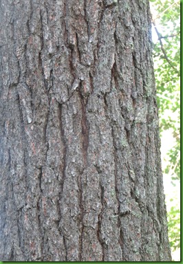
It is easy to show how to tell the red and white pines apart. White has 5 needles per group and red has only two but the most telling is their bark.
The tree on the left is white pine. The bark is gray and horizontal.
The tree on the right is red pine. The bark is reddish and in plates.
I do love knowing which pine is which in this forest of ancient pines.
Just across the road from the Landmark Trail is the Blow Down Trail. It too is a half mile loop with a 2/10th popsicle stick intro section. A severe wind storm in 1995 ravaged 325,000 acres of forest in north-central Minnesota, knocking down mature pines and hardwoods in Itasca State Park and the surrounding area.
The Blowdown trail traverses a stand made up primarily of mature aspen which was leveled by the storm. These were saplings when the logged over land was annexed to the park in 1919. After the blowdown, salvage logging removed the damaged and downed trees from one area to encourage maximal aspen regeneration from their roots. Aspen are spurred in growth by trimming. Another portion was left alone to recover naturally providing a contrast that is supposed to illustrate the choices involved in managing a natural area. The debater about whether to log dead and downed Timber seems on going.
We found this trail to be very difficult. It is nearly overgrown and since it has been almost 20 years since the blowdown, things have changed a great deal and it is hard to tell which section is which. Only in one section toward the end do the aspens seem to predominate.
The trail is a good educational idea but its information needs updating. Actually I think nearly every park could benefit from updating its trail information at least every 10 years. How many times have you been on an interpretive trail and the sign points to or discusses something no longer there.
You can barely see the trail here. We get very wet.
The highlight of this hike is not the blowdown but a tiny lake on which these ducks were swimming in groups right next to each other. I am at a loss on these two groups. I thought perhaps a female wood duck because of the white eye ring. And perhaps a buffle head because of the cheek patch but other things don’t match. I sure hope Judy is reading so she can set me straight. Or anyone else who knows, please. Who ever they are, they were the best thing on this trail today.
And on the bushes just at the edge of the lake was this bird. Can I get an Amen for a female Red Winged Blackbird? Or???
With pant legs soaked from the knees down we move on to the Bohall Trail which is actually in the 2000 acre Wilderness Sanctuary. It’s a mile round trip and leads to Bohall Lake. There are lakes absolutely everywhere here in Itasca. It seems like at least one per trail no matter how short the trail is.
This is the area with the 100 to 300 year old red and white pines.
Notice the mosquito head gear, hands in pockets and the tick prevention socks over pant legs. We are taking NO chances here. Though the sun is blazing, the temperature is in the low 60’s.
These are really BIG trees. Check out David on the trail.
We arrive at Bohall Lake and WAY out there on the water is a family of four swans. Boy we are on a roll here.
Our next stop is a great comparison with this one. The CCC Forestry Demonstration Area trail is 4/10th mile loop which highlights the replanting of pines in the 1930’s in areas that had been logged in the early 1900’s. The trail, developed in 1971, loops through 21,000 red pines and 5,500 white spruce planted by the CCC from 1937 to 1940.
These were only about 30 years old when the trail was put in but now they are around 74 years old. Still a great difference in age from the 100 to 300 year olds in the Sanctuary area we have just been in.
The major difference we see between the two areas is not in the height of the trees as much as their circumference. It is also obvious that these were planted and did not grow naturally. They are much more thickly spaced than the old growth trees.
There are information boards along this trail and they seem to be favorite spots of the dragonflies today.
The dragonflies are thick along this trail and it seems they must all be alike until I get back and look at my pictures. Close but not exact. I know nothing about dragonflies. Male and female here? Or????
You can have the bottom part or the top since if you get far enough away to get the entire tree, its neighbors are in the way although David does as good a job as possible I think. Can you even see me down there in the lower left?.
At the time the information sign was put up, they don’t indicate when, the tree was 112 feet high, 173” in circumference, had a 49’ crown spread and was estimated to be over 300 years old.
With a rail around it, they are protecting this baby from hugging. But they can’t protect her, yet, from white pine blister rust, a disease introduced in the early 1900’s from Europe or from heart rot, a fungus that attacks and decays the core.
That’s a big footprint. We wish her an even longer life!
Sadly next we see the end of a Monarch. This red pine was the Minnesota Record Red Pine until 2007 when a wind storm broke off its top. It is now displaying the natural process of aging and what happens next is unknown. These statistics were from a 1998 measurement. Height 126’, circumference 120”, Crown spread 48 feet, Age 300+ years. After seeing this information and date we speculate that the White Pine statistics were also taken in 1998.
It is still a grand tree but showing the signs of age. These pictures show what is happening. The tree today still looks like the 2007 picture. 7 years and holding is good especially after such a rough winter this year.
The red pine is even harder to get a good photograph of. I’m there at the bottom of the picture on the right for size comparison. The picture on the left just shows the top part of the tree for comparison with the photograph above. The red pine is back off of the boardwalk and its base is obscured by bushes. It appears that, for good or ill, you never could walk all the way around it like you can the white pine.
Located on a small seemingly unused trail just to the left of the Big Red Pine trail is the Bison Kill Site It doesn’t look like much now but it was here in 1937 that workers rebuilding this portion of Wilderness Drive found remnants of primitive bison, along with spear points and tools from the Archaic period.
Detailed excavations in 1964-65 showed that two thirds of the bones were most likely Bison Occidentalis, a species of giant bison that became extinct 5,000 years ago. All the artifacts found suggest a date of 7-8,000 years ago. The climate then was at its maximum warmth after the glacial age and what is now Itasca was on the edge of the prairie. There was no sign of habitation so it is likely that these hunters drove the bison into the mire and then killed and processed the animals. I just learn the most amazing things everywhere I go. This is the information find of the day.
We’ve come to the end of the trails we are going to do today but we do make a stop at Elk Lake further on down the drive which looks like it would be another good kayaking spot. An osprey soars over head.
A sign nearby explains the controversy over whether the Mississippi begins in Elk Lake which drains into Itasca via Chambers creek. After reading it, I for one am wondering but the point is moot by this time. The river only becomes a true river when it flows out of Lake Itasca. The first drops of that river may have originated at any of the springs which feed the smaller bodies of water which feed into lake Itasca.
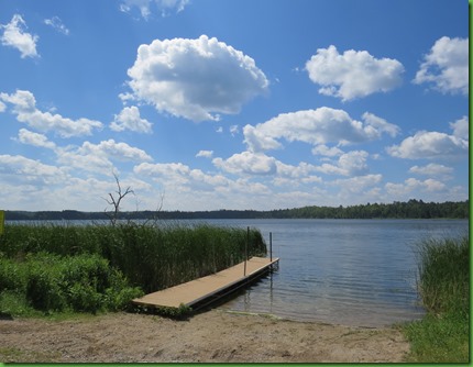
Water flows out of Elk Lake into Chambers Creek and from there into Lake Itasca which is the lake in the distance of the picture on the right.
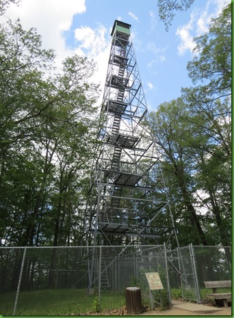
Our last stop is to climb the 100’ Aiton Heights Fire Tower. It’s a mile walk round trip and a stiff climb up the fire road. Then 135 steps up to the top of the tower. The wind was blowing so hard it took my hat off even though I had it secured under my neck. But I didn’t feel the tower moving.
When we arrived, there were only a couple of other people on the tower so we were able to go right up since the number of people allowed on the tower at one time is 6. But by the time we came down, a line had formed. The view is fabulous.
You climb from the ground, through the understory and the canopy and the tree tops to above it all. And because the structure is metal you can see at each level all around you. At the top level just below the roof are pictures of each direction and what you are seeing. We could see all the places we had been over the days we’ve been in Itasca. People look like ants below. Not for those with a fear of heights.
On the billboard at our very first stop this morning it said “The minimum drive time is one and a half hours, but you will miss a lot if you try to drive it in that time.” Obviously we didn’t miss much. We’ve spent 6 hours this morning. And what’s really great is that it is only 1:00 in the afternoon when we get back to Winnona. The crowds were just beginning to build up at our last stop.

One last note: When we were here in 1991 it was the 100th Birthday of Minnesota’s State Parks and thus of Itasca State Park. Charlie Maguire had been appointed Centennial Troubadour and commissioned to write a group of songs about the parks. Many of them were about Itasca and all were published on the cassette “State Park Tapestry”. We often bought the books and music of an area in which we were traveling and we bought Charlie’s Cassette. The three of us (Carrie was 11) loved the music and the songs and sang along as we visited many of the parks for which they were written.
This visit, we could not find the cassette, seems Carrie has it! So, we contacted all three of the visitor centers in the park and found that they are no longer carrying the new CD entitled Wilderness Road. We were shocked as they have little phones outside the Mary Gibbs Visitor Center at the Headwaters from which you can listen to part of his song about Mary Gibbs. His original research into her importance at this park is yet another story.
In any case, we contacted Charlie about this and he graciously sent us a copy of the CD and one for the buyer for the visitor centers. We intend to take it to her in person so that hopefully when you come to Itasca you can buy a copy of this great set of songs from an American Troubadour. You’ll be missing something if you don’t sing along.


Great pics.
ReplyDeleteI am amazed you made the fire tower after a long hike. As a kid my friends and perhaps myself enjoyed spending the day in a abandoned fire tower. You could see for miles from there. I still enjoy them when I can.
Thank you for the pictures from that tower. You'd never get me up there. That's why I joined a sea service, I worked at sea level. ;c)
ReplyDeleteYou certainly are styling in those anti-skeeter hats!
With all the mosquitoes it's a good thing these are short trails, yet you see so much along the way. Love the views from fire watch towers.
ReplyDeleteAs always lots of good information and accompanied by great pictures. But with you hiking in those head nets, Im having second thoughts if we would even go there. I know :( But for now your pictures are good enough to appreciate your hike and what you saw.
ReplyDeleteYes those are female red winged blackbird.
Cute ducks and beautiful trees. Quite a history. Sounds like all but the blowdown trail was very nice, especially the firetower views. I remember singing along! Great tape :) I bet Charlie was happy to hear from you :) What times we had and still do!!!
ReplyDeleteFantastic view from the fire tower.
ReplyDeleteYep, the early bird catches the worm or at least gets first short at it ;o)) Something special about seeing these beautiful spots without a lot of company!!!
ReplyDeleteWhat beautiful swans! They are so graceful. Nice view from the tower, not sure I could make it up after that long hike either, but worth the effort I see :)
ReplyDeleteI love all the great information in your posts - there are so many things to learn in every area! I can't even fathom a wind storm that isn't a tornado doing that much damage in a huge forest. Can you imagine the sound it made?? I'm thinking the Mississippi originates in all of the springs and creeks that enter Lake Itasca? Thanks for going to the top of the fire tower for me. Even with an elevator you wouldn't find me up that high, and open, and.....yeah, I don't do heights well :-). I'm loving the ???? for your leaving date and sure hope you get in some more paddling on all those lakes!
ReplyDeleteWow, this was a true adventure. Thanks for sharing.
ReplyDeleteI think your ID on the ducks is pretty good!
ReplyDeleteEvery time I see photos of you guys in your mosquito gear, I think….hmmmmm….not sure if I want to contend with that many biting bugs. But your hiking and kayaking adventures are so terrific, it seems worth the trouble.(Nonetheless, I think we'll wait until fall to visit that area….)
ReplyDeleteYou are certainly doing this area of our country justice with all your exploring. I marvel at your hiking in any conditions even wearing all those clothes and mosquito netting. We have decided to forgo stopping in these area since the bugs are so bad. We'll just drive through and head straight to Glacier. I am, however, still looking at a possible detour to take the Painted Rock boat tour. I really enjoyed your blog on this trip. You make me want to see many of these places but I have little tolerance for that many bugs...it could get ugly if I were there:)
ReplyDeleteDon't get too scared off. To clarify about the mosquitoes, we have only worn our "gear" a couple of times on this trip. And we really haven't been bitten at all. The mosquitoes are light in most places and the wider the trail, the less the trouble. Also early morning and early evening are the worst times. We didn't have our bug gear on for the last part of this trip. That said, if you want to avoid mosquitoes as much as possible, I guess you'd better wait until after labor day to visit.
DeleteMost of my hikes are around the golf course. Yesterday I got to hike around a large number of destroyed trees from the recent storms. I don't see as much interesting stuff as you two but I also don't have to protect myself from bugs. Besides, I can vicariously enjoy your hikes by reading the blogs!!! Cheers!
ReplyDeleteSuch cute Buffle Head babies! We get them passing through here every now and then but haven't seen them yet this year.
ReplyDeleteLove the big trees! Also the photos of the bark on the pines. I love the differences in bark and have taken photos of it- the different colors and textures are so cool!
ReplyDeleteXXXOOO