Saturday September 3, 2016
Dingmans Campground Most Recent Posts:
Delaware Water Gap Fossils on the Trail, Mice in the Kitchen, Unique Graveyard in the Woods
Dingmans Ferry, Pennsylvania It’s Carefully Doable But Probably Not Adviseable
Today we go over the historic bridge to the New Jersey side of the Delaware Water Gap to have a look around. I talked about the bridge in a previous post from here. We are headed for Buttermilk Falls. I think every state we have been in has a Buttermilk Falls. Why is that such a popular name?

Looking down at the river while we are crossing I see lots of kayakers. Today is Saturday so I’m not surprised. I am surprised that we are out and about but we’re just exploring so it shouldn’t matter how many folks are also around.

On the way to the falls we drive through one of the shrinking little towns of this area, Wallpack, NJ. You have to love the town’s claims to fame. Guess if you were once president even your mother-in-law makes the news.

The town is tiny though there is some renovation going on at two homes. The church and the schoolhouse are both darling and look abandonded. Not sure why a school of this vintage would have a two car garage. It appears the town council used to have its meetings in the school but the most recent one was cancelled.


David is tall enough to peek inside.


We head on down the road to the trail head for the falls. There is a large parking lot but no trail. The falls is right opposite the parking lot, no hike necessary.

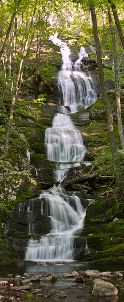
We take some pictures of the suffering falls and see the information sign. I try to imagine how magnificent they must look in the spring,.

When putting this post together, I find this picture of more waterful times.
The map on the information sign shows us that there is a Buttermilk Falls Trail that goes up to the Appalachian Trail from here. The information says the trail is 1.4 miles long.

After seeing this map that shows the AT going to some lakes, we decide we’ll hike up today since there isn’t any reason to come back here to see the falls a second time.
There are 26 miles of the 2184 mile Appalachian Trail in the Delaware Water Gap along Kittatinny Ridge. Crater Lake looks like a good destination. About another 1.4 miles for a total for the day of 6 miles.

We don’t think much about this information but we do note that it is a mile up hill.

The trail goes off right next to the falls from the information sign. Up hill of course.

We grab our hiking poles take some last pictures of the falls and head up the trail.


It’s pretty steep as it goes up right next to the falls.

Steep enough to require steps with encouragement.


Every Journey
Starts With
One Step.
The steps end but the railing continues on to help you over this glacial striated rock. Whoo hoo, I remembered something I learned yesterday.

There is a nice flat wooded area here at the top with a wooden deck overlooking of the top of the falls.

Then it’s on up the trail which is less steep but more rocky at first.

It gets more steep and more rocky as we go.

We get to what looks like the top but of course it isn’t.

This makes for some mighty difficult up hill climbing.


The trail is rough and difficult but we’re maybe half way so we press on.


Finally we come to the top where the sign there informs us that it isn’t a 1.4 mile hike but rather 2 miles one way. That makes our hike 4 miles and we haven’t taken one step on the AT. We didn’t get a particularly early start today thinking we were just going to be cruising around checking things out. Doubt we’d have done this if we’d known it was two full miles up hill. I have to say, that’s what it felt like. David said it was the longest mile and four tenths he’d ever climbed.

Thankfully the AT is relatively flat here.


We appreciate some nice views from atop Kittakinny Ridge.

And then the AT starts to do some tricky things.

How do you get down from here with a 25-40 pound pack? The white blaze says this is the way.

And this is the way.

Yup, down there. Does that mean we have to climb back up and out on our return?


This part of the trail doesn’t look very well used. I guess the through hikers going both ways have already come and gone.

We do finally reach Crater Lake. Obviously we’re not in Oregon.

It’s a very lovely spot and perfect for a late picnic lunch.

But the path turns to nothing before we get there. Some bushwhacking anyone? Can you see David coming through the bushes?


Somewhere there must be an easier spot to access the beach lake front but we don’t see it from here and think this will do just fine since we still have to go back.

We do see some boaters hanging out on some rocks in the water. So there must be a boat launch out of sight. Looks like a big lake.

Here’s the lunch spot.

And its view.

Here’s David finding his way back up from the lake.

3:00pm and we’re back on the AT.

Another unusual white blaze.

When we return back to the Buttermilk Falls Trail we notice someone has written their opinion on the post.


It’s tricky footing going down.


And it seems to go on forever.

We finally reach the bottom where there are quite a few more people enjoying the falls with apparently no intention of climbing this trail.

The Buttermilk Falls Trail is definitely a good workout.
I’d call it strenuous in my guide book.
Ever since I hiked a little over 1/3 of the AT in 1997, I've dreamed of going back and picking up where I left off. I no longer have any desire to climb rocky trails. And New Hampshire is much worse! It's a beautiful trail though, but for folks much younger than I am.
ReplyDeleteThe AT section we hiked was only difficult in that one spot. The trail up to it from Buttermilk Falls was very difficult especially for David.
DeleteWow, that looks grueling! Thanks for taking us along through some really rough terrain. So sad to see the falls trickling, although the rocks are gorgeous.
ReplyDeleteLooks like more rock than trail.
ReplyDeleteYou two certainly have been finding some rocky, rooty, slippery trails lately. Geez. Makes me kind of glad I am home for a change. I love hiking, but after awhile I would really get tired of fighting those slippery roots. Instead, today, I spent the day quilting. I'll bet you are in a lot better shape than I am lately. Ha! Happy Trails to you!
ReplyDeleteAnother beautiful trail. Crater Lake looks like great spot for lunch!
ReplyDeleteShort but strenuous, you did good!
ReplyDeleteThose 4 miles straight up and down over rocks didn't seem short. :-)
DeleteYep, you got your workouts today!!! I usually like rock scrambling, but not over those tinier ankle breaking rocks. I like the big rocks if there has to be rocks;o)) You certainly found a pretty spot for lunch. You should make a coffee table book of "Natures Lunch Spots Across America!"
ReplyDeleteWow!! After that, I would've been pooped...pretty, but that looks like it was a lot of work!! You definitely hiked more than expected that dqy. Phew!
ReplyDeleteWow. That was definitely a strenuous hike. I don't like all those rocks. I trip too easy. LOL. Great job.
ReplyDeleteThat is a rough trail. Crater Lake's a beauty, as are those falls. I think there's a Buttermilk Falls here in Ontario.
ReplyDeleteI must admit I was totally exhausted at the end of that hike, but I enjoyed every minute if not every step, thankful to be able to climb to such beautiful sights. ;)
ReplyDeleteWow what a rocky path, I find those sap my energy too. Beautiful part of the world.
ReplyDeleteWow, that was a difficult trail with all of the rocks and roots, and strenuous with the steep uphill climbing and descent. I think the person expressing the sentiments of "Don't do it!" was probably right. But then again, you wouldn't have the satisfaction of completing the challenge and seeing a beautiful place off the beaten path.
ReplyDeleteYikes! Steep and rocky... Bad combination. Especially that one coming down off the high rock where it doesn't even look like there is anywhere to step. At least the falls were pretty and the view at the top was nice. Always nice to see water. xxxooo
ReplyDelete