Wednesday-Thursday May 30-May 31, 2018 Recent Posts:
Big Meadows Campground Foggy Meadow and Moving On
Shenandoah National Park, Virginia Laurel Prong

Rain started Tuesday evening and it rained most of the day yesterday. I had the F CODE on the Norcold Refrigerator again in the morning. It has developed a pattern the last two weeks of showing up on Wednesday and Thursday mornings and then it takes a break for 5 days. The rain stopped for long enough that I could do about 4000 steps just walking around the many loops of the campground. I also went down the mountain for groceries which is a 50 mile round trip. I was really lucky to get back before it started pouring. No rain or fog at the bottom of the mountains in Ruckersville, Virginia but the dense fog started as I climbed the mountain back up.
The rain was torrential over night and filled up a 3 gallon bucket I keep outside as a rain gauge. I learned this morning that 2 people were killed in Ivy near Charlottesville in a flash flood. A third man swam to safety.
Lewis Mountain’s internet is not strong but Big Meadows has none period. You have to walk or drive up to the lodge to get a signal and if the fog is dense, that’s not certain. So that’s one reason I’m so far behind on posting. Couldn’t do anything Wednesday night but read.


I walk about a mile down the AT before turning right and heading down the Lewis Spring Trail and it is DOWN.

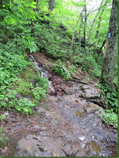
At first, it’s a gentle down. Very nice, not muddy, not even wet.. Great I think.

However, that doesn’t last long and it gets rockier and muddier as I go. In some spots the trail is a stream in others there are little pools deep enough to reflect.. Very glad I have my hiking pole


The trail is narrow and rugged. Large rock faces line some sections. Large leather looking leaf like lichens, which I think are rock tripe, drip water. Pour water is probably more accurate.


Yes that tiny little brown rock line is the trail.

At points, Mountain Laurel lines the trail. It is bright and beautiful in person to see it ahead of me on both sides but the pictures don’t do it justice.


Such an intricate design. Magnificent! These Appalachian mountains have the most gorgeous bushes in the Mountain Azalea, the Mountain Laurel and the Rhododendron. You have to see it to believe the beauty.


Should be plenty of rose hips in the fall.

Mini falls come down the mountain and over and/or down the trail along the way.
The trail is actually a lollipop. The cement post indicates that the return route is to the left and up while the falls are straight ahead and down some more. When it’s wet and slippery, down is my less favorite direction.

Here I am at the rather over grown top of the falls. Today it is over run with water. The rocks one normally can just walk right across are under fast moving water. The cement marker points across the water which is way overflowing its banks and has apparently moved some of these downed tree pieces to new locations.


What to do? What to do? Do I try it? While I debate in my mind whether to take the risk, two couples have come down behind me and they decline. But the real view of the falls is down at a rock ledge viewpolnt. I have a beautiful view of the overflowing Hawksbill Creek tumbling down at the top but no real view the 81 foot falls.


What I do have views of to the right of the creek are the beautiful Blue Ridge Mountains

Perhaps they will be today’s prize for my effort.

While I’m taking the pictures of the views, another couple comes down, looks around and heads over the creek. He’s ahead of her and I’m just quick enough to get a picture of her as she crosses. Now granted they are younger than either me or the other two couples both of whom were also younger than I am. She takes her time and makes it look doable.

I debate some more and then decide, yes I’m alone, but at least they are down there if I fall and I have an id bracelet on with names to contact. I’m in the last years of my hiking life and I’ve come this far so I’m going for it.
It’s very scary but I do it. Without a hiking pole, no way!
I’m rewarded with a much better view of the tumble over the top.

It falls over the top, flattens out and falls again.

A short distance on is the metal hand rail to help with the steep drop at this point.


I’ve arrived at the stone viewing platform which I’m pretty sure is a CCC creation.

The view from the close edge seems far away. I’m sure there must be a trail to the bottom of the falls but not from here. I suspect you would have to investigate what the locals in Madison County know about going up some county roads until they dead end into the park and become gated fireroads on what were once the displaced residents’ roads of transportation. I wonder if I’ll remember to ask about that at the visitor center?

By moving along the wall, I get a little longer view. But no view of the bottom.

Zooming in gives a better idea of the size.

That’s a mighty lot of water falling over those rocks.

I turn around and head back up getting a slightly different view of the top of the falls.

The creek looks a little less wild on the way back except for all those wet slippery rocks I’m going to have to stand on.

Climbing up the trail along side the creek seems easier at first.


It’s nice to be facing the water as it is flowing downhill and I’m climbing up.


After I cross over here, I’ll be hiking away from the creek.

Looks a little more sketchy up close than from a distance.

The water changes by the second it seems. But I manage.


As the trail continues on the other side, I see many Solomon’s Seal. Their little flowers are darling.


The trail continues to be a constant uphill through more rocky terrain. I’m near the junction with the AT when I pass by this locked door in the side of the hill. I can hear gushing water behind it.
Having done this hike before I know it’s the spring which is the principal source of water for all of Big Meadows and the source of Hawksbill Creek which forms Lewis Falls before flowing on to Luray Virginia and eventually to the Shenandoah River. It’s fun hearing so much water behind a closed door.

The last section of my hike begins with a puddle when I turn left onto the AT and climb some more back up to the Big Meadows Amphitheater.

Steadily up hill but not at such an incline as the Lewis Spring Falls trail.


Along the way are more views of the Shenandoah Valley


Only a small puddle left back at the campground but I have a visitor in my backyard shortly after I return.


I have done this hike previously and at that time there was much less water. It seemed like a lot of work for little reward. I probably would not have done it again had it not been for the increase in water in all the falls and that I could do a challenging hike without driving to the trail head.
Because the view of the falls is at such a distance and is not complete and because the trail is a difficult hike under most conditions, I can’t unreservedly recommend it. That said, it was a good way to spend this one of many days I have here in Shenandoah National Park.
"Lot of work for little reward" is the exact way I would describe this hike even without the muddy conditions. You can't get close enough to the water fall for all of the work and I always feel like I am about to slide off the cliff in that really rocky section. It's interesting to see it with higher water though. Thanks for sharing!
ReplyDeleteJust glad you were able to do it without an accident!!! We too like a reward when we hike. However, more and more, I just find it therapeutic to wander around in such beautiful places:o))
ReplyDeleteYeah, maybe not. I probably would have chosen to do something else. It always amazes me that you can manage to find beauty on these kind of rough, slippery, rocky, steep, not much of a view, wet kinds of trails. More power to ya, Sherry!
ReplyDeleteYou sure earned that view of the falls:)
ReplyDeleteSometimes when there is no reward or we get lost or get off track or there is an obstacle, we just console and convince ourselves that we are getting at least a work out and outdoors. Glad that you made it through bravely and safely.
ReplyDeleteYou definitely earned that view!! Glad you stayed safe. Looks like a tricky trail, but beautiful nonetheless. Great pictures! I love all the water, even if it does make the trail slick and muddy. Beautiful sounds.
ReplyDeleteHmmm...I'd have to agree that one was a LOT of work. Rocky, muddy, slippery, steep, wet, and not much of a view. :-( But you did find beauty along the way, as you always do. And there's always a sense of satisfaction in just getting a good workout. Still, I think I'll pass on this trail. Your rain gauge bucket is hilarious. :-)
ReplyDeleteThat's a bummer to lose that nice chair. Glad you didn't let it ruin your wonderful hike (with all the muddy trails). You can find a silver lining in the foggiest conditions with all the beautiful flowers you found. ;c)
ReplyDeleteRemember this hike well ... remember also thinking that it was too much work for little entertainment value because of the resticted view of the waterfall. Regardless, did it a couple of times when we lived in VA for the exercise value.
ReplyDeleteNice falls at the end of a nice hike.
ReplyDeleteThe waterfalls are gorgeous!
ReplyDeleteI get that need to get out but sometimes you just amaze me. I'm mostly a fair weather hiker. It's all gorgeous, the green, dripping, and waterfalls. Does the door hold the water back? ;)
ReplyDeleteNow that I have Internet again I can get caught up with all your wonderful posts. Aren't the waterfalls wonderful when they're so full?? You were brave to take on that wet crossing, but I agree it always helps to see someone else do it first :-)
ReplyDelete