Friday September 5th 2014
Portal RV Park near
Arches National Park
Moab, Utah
It’s a 30 mile drive from our campsite to Canyonlands and we are on the road before sunrise.
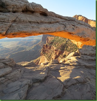
But we don’t make it to Mesa Arch for sunrise. Apparently a lot of serious photographers do. When we do arrive most are gone and the last few are taking down their gear and painstakingly cleaning it for sand. It is clear that had we been here at sunrise, we would have had a picture of the backs of a row of photographers lined up in front of the arch.
We didn’t get THE picture all the photographers were wanting, the one on the postcards. But we did get some interesting angles and some nice illumination of the underside of the arch.
The view through the arch is stunning. No wonder the photographers were edging each other out.
After seeing the main attraction, Mesa Arch, we head back to the Visitor Center, which hadn’t been open when we arrived in the park, to see how to structure our day. Again they have an Audio Tour, $5 to rent, $10 to buy. With only one day to spend here, we think this is the best way to learn and see as we go down the drive.
We check things out on the giant topo map we have come to expect at visitor center. From the map and information at the VC we learn that Canyonlands is 337,598 acres of canyons, mesas, buttes, fins, arches and spires in the high desert of Utah.
It is divided into 3 districts by the Green and Colorado Rivers: Island in the Sky, The Needles and The Maze. Each has its own character. There are no roads within the park that directly link the districts. It requires two to six hours by car as there are few places to cross the Colorado and Green Rivers.
The Needles area can also be reached from Moab. It’s a 76 mile drive and with more time we would for sure visit there. The district we’d most like to go to is of course the least accessible, the Maze. It is available only to high clearance preferably 4 wheel drive vehicles. Not sure I want to see people off roading in this beautiful landscape but the remoteness of the Maze area sure does appeal. Seems like you could spend months at Canyonlands seeing all three areas.
Our first stop on the drive is Shafer Canyon Overlook where we are really surprised to see that a road hugs the wall of the canyon below. It’s one lane wide with pull outs for passing and descends 1400 feet in five miles of switchbacks and precipitous straight-aways. I’m sure its surface is dangerously slippery when wet and impassable in winter. So I’m amazed to find out that this route has provided access from the rivers and lower canyons to the mesa top for hundreds of years. Native Americans used it, outlaws and rustlers used it and ranchers used it. Today the Shafer Trail provides access to the Canyonlands’ back country and the 100 mile White Rim Road for 4 wheeling and mountain biking.I find all of this out by walking the 200 yards down into the peninsula of land below the parking area where there are two interpretive signs.
There is a 5.8 mile loop trail here called The Neck Spring Trail. It drops 300 feet into the canyon to Neck Spring and then to Cabin Spring. Not sure a down and back up this steep canyon would be on my list even if I had the time.
As we travel along stopping at overlooks, it becomes very clear why they call this Canyonlands.
At Grandview Point overlook there is an illustrated picture showing us exactly what is out in front of us and another that explains how the canyons were carved. In a nutshell it is water and gravity. From here we can literally see the geologic history of this area, the shale and 6 different types of sandstone.
At this point in binoculars, we can see both the Colorado and the Green Rivers. We are nearly at their confluence.
A very short distance down the road is the Green River Overlook. Zooming in we can see it well. The Green River begins in the Wind River Range of Wyoming and meets the Colorado just beyond this point. It definitely looks green but of course it’s not, it’s brown as you would expect it to be as the recipient of all the red rock erosion. The green is the growth around it. We are at 6000 feet elevation as we look down at the capstones keeping the rock beneath them from eroding away.
Our next stop is my favorite of the day. At Aztec Butte Viewpoint we take the trail to visit the Granaries. Not sure why it’s called Aztec since those people were in Central Mexico. The people who built these granaries were called Anasazi but more recently and more accurately ancestral Puebloans.
Amazingly it is nearly 10 degrees cooler here in Canyonlands than it was and is in Arches. Not sure why that is but it’s wonderful and really helps us make a full day of it on our visit.
The information says that by climbing Aztec Butte you will get to see the granaries but we find they are two separate places. From the parking area at the viewpoint, the trail to the granaries is a total of a half mile up. We aren’t sure which of these is which as we start out and hope the signs will make it clear.
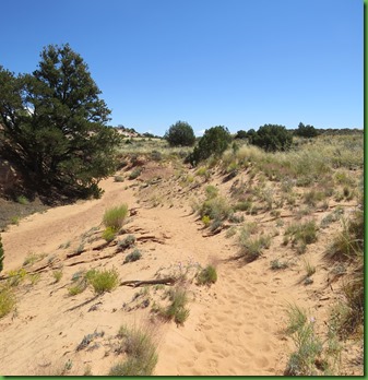
The first .3 mile is fairly level and very sandy. The train runs through a wash. Then it climbs up up for the last .2 of a mile.
At the very end you are on some tricky slick rock and have to be very careful. It is a LONG way down. But the views are fantastic.
Straight up the slick rock. Thank goodness for the cairns.
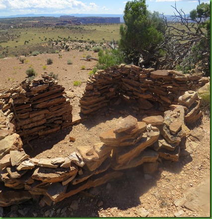
The granaries are hidden under the ledge of the rock. RIGHT ON THE EDGE. There isn’t a lot of flat footing. Everything is sloping down. But being here is just amazing. A little bit of Mesa Verde all to ourselves.
There are two granaries next to each other. Apparently large boulders were placed over the front to keep out the critters. Not sure how in the world they did this with the small amount of room available for moving around. Remember those views and how far up we are.
Further to the right are other alcoves that might possibly also have held granaries no longer here
The construction is incredible. It’s still here thousands of years later. Will your house or former home be around in 2314??
Getting back down is easier than coming up. Our next destination is that round butte on the right. That’s Aztec Butte.
The total round trip to the top of Aztec Butte is 2 miles but it is described as “traversing steep uneven terrain with drop offs and ledges up to thigh high. (I wonder whose thighs, mine or David’s?) Some scrambling on hands and knees may be required.” It is listed as a strenuous hike. Well all righty then!
Yup, more straight up. More cairns to direct us thank goodness.
Ok now where?
Up there?
Why does it look further away now than it did just a minute ago?
It may be rocky but at least it’s a path.
Almost there.
We made it! Definitely a serious hike to a flat top. Look at those views. I finally learn from Barry Lopez in his book Home Ground: Language for an American Landscape that a butte is a mesa’s orphan, the freestanding remnant of a larger landform. It is flat topped and steep sided, always taller than it is wide. A mesa is wider than it is tall. I highly recommend this book. It’s an eye opening reference.
The granaries here are much easier to find. I assume they had tops on them at one time. Perhaps this area has really changed since they were created.
After walking all the way around the edge of the flat top of the butte, we are back to where we came up and it’s time to start down. Carefully……….
You can guess how much David enjoyed taking these pictures.
Ok now just walk straight across this nearly perpendicular side of a butte to follow those cairns.
And now how about straight down this slick rock.
I’m not the only one using hands to negotiate this hike.
When we reach the bottom we both have to say that was the highlight of a so far terrific day.
Once down, we get some harassment from a local resident. Being from the east where we have the intelligent and noisy crow, the Raven seems huge and his low croaking sound is nothing like the caw of our crows. He also hangs out alone or in pairs not in the groups of the eastern crow. So the raven always attracts my attention. His shiny black feathers have become a color name. Everyone knows exactly what you mean if you say someone is raven haired.
Our last stop for today is take the first overlook trail to Upheaval Dome. What a mystery this is. But a really beautiful one for sure. There are 2 trails which go to different sections of the rim of the dome. In length they are 1 mile and 1.8 miles. The one mile trail is on the way to the 1.8 mile trail so we’ll decide how far we are going when we get there.
Like everything else. This one is UP.
I’m running a little low on oomph for up so I’m pleased that it isn’t too steep and getting to the top seems relatively easy.
Come on, what are you waiting for?
As you can see, I’m pretty far ahead on this last trek.
And then I get to the rim. Good grief. Would you look at that!
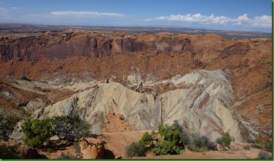
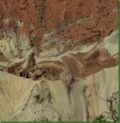
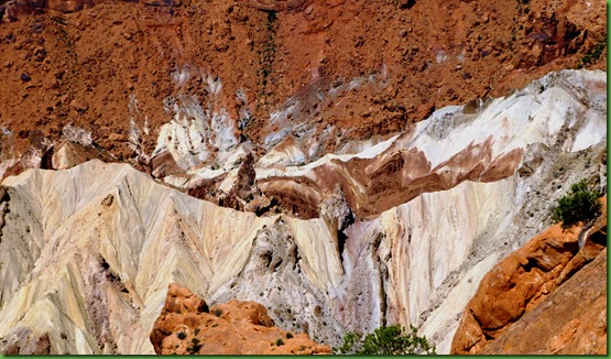
The rock layers are fractured and tilted forming a circular depression more than two miles wide. Isn’t this amazing?? I can’t get a “whole” picture. It’s just too big. But we are able to determine that the view from here is quite fine and will not require that we walk around nearly another mile and then back for a different angle.
There are a couple of theories about how this “upheaval” came to be.
Look a little more closely while I tell you the story.
The first of the “upheaval” theories is that 2 million years ago a meteor hurdled toward the Earth and hit the ground with so much force that it vaporized on impact. The force of the impact fractured the rock creating a large crater. Rock layers rebounded inward and upward to fill the void. Erosion removed the top layers and exposed the tilted broken core of the impact site.
The second theory is that 300 million years ago a salty sea covered the area. The sea became trapped in a large basin, then evaporated, leaving behind thousands of feet of salt. Water and wind deposited more sediment pushing down on the softer salt layer and causing it to dome upwards Over time the salt rose fracturing and distorting the rock layers in its path. Water eroded the salt and overlying sediment exposing the distorted crater visible today.
So what do you think?
Time to head back DOWN the easy well marked trial. It’s always nice to finish up with something downhill.
It’s a bit longer drive home since we are at the end of the Canyonlands Scenic Drive. We stop on the way to return the CD and then it’s straight on back for a delicious black bean salad dinner.
Tomorrow is our last day in Utah. Then we’ll be heading east toward the coast in a bit faster manner than usual but we’re only doing minor PDD. It might not even rate bronze.














You had quite a day in Canyonlands! Isn't it fun hiking on that slickrock?
ReplyDeleteWe rented a jeep in Moab so we could drive the Shafer Trail. Pretty exciting going down. After seeing all your photos I'm glad we're on our way to southern Utah.
The cairns would be a big help. I got lost going to Delicate Arch!
ReplyDeleteVirtual hugs,
Judie
Great, great, great pictures!!!! Just love that hat..... you have Sherry :)
ReplyDeleteYour pics make it look more impressive than the Grand Canyon. I sure wish I had your hiking abilities.
ReplyDeleteIt isn't just Sherry's pictures, although wonderful, Caanyonlands is far more impressive than the Grand Canyon!!
DeleteSherry thank you for your blog on Canyonlands. We're not going to have a chance to get down there this trip. We'll be leaving for the Grand Canyon tomorrow. Great pictures and I love the "butt sliding" down the slickrock!
ReplyDeleteWhat a hike, and what a beautiful park!
ReplyDeleteno, no, no. . .those hikes look treacherous. . .I would never trust myself. . .you guys are amazing!
ReplyDeleteNot that your bonnet isn't adorable and all. . .but have you considered a golfer's visor. . .I purchased one at the Golf Hall of Fame that's probably almost as large as the brim of your bonnet. . .you may not need it back East. . .but just a thought? ? ?
Wow, you two had a super day! Great photos. Lots of great memories until you two return.
ReplyDeleteI found taking pictures at Canyonlands frustrating...could never get a picture as awesome as what I was seeing. We couldn't do any hiking with the dogs, so thanks for doing it for us :-). We did drive down Shafer Trail and had a great time!
ReplyDeleteI spent many years in Canyon Country. Drove the Schaefer Trail and biked the White Rim, got caught in a flash flood in the Needles. But the most amazing experience of my life was the six days I spent in a paddle boat from Moab to Hite. I hiked from the Confluence into the Maze. 1200 vertical feet from the river. We had it to ourselves. In all my trips to Canyon Country I never made it over Elephant Hill and never drove into the Maze. I am so glad you saw it. You did a great job photographing Mesa Arch. Loved seeing the photos of the places I love and remember.
ReplyDeleteLove your bonnet....You fit in as an early pioneer, now all you need is yards of material wrapped around your lower half into a skirt. Hiking boots are definitely a must. I loved how they grabbed onto the slickrock. Another great day!
ReplyDeleteWe love Canyonlands! We stayed there a couple of years ago (in the Needles district) and wondered why it had taken us so long to discover this gorgeous place. You had such a glorious day, from the beautiful sunrise to your awesome hikes on the slick rock. Thanks for the great tour!
ReplyDeleteI so miss Utah. I do believe this is my favorite state. We did all the hikes you did. I felt like I was looking back at many of my own photos:) Thanks so much for taking me back. We will be in the area all spring. Looks like you got a nice taste of Canyonlands. You must do the Needles when you return. Now there's some fantastic hiking.
ReplyDeleteBe safe as you move east. Don't get too tired.
Thanks for taking us on those amazing hikes!! We love hiking on rocks and butt hiking if necessary to do so safely;o)) You sure packed your day to the brim!!!
ReplyDeleteThis is just overwhelming for me and I can't wait to see it for myself someday! I can't imagine how frustrating for both of you at having to cut the trip so short.
ReplyDeleteGreat pictures and neat graneries.What views! Difficult hike...need to be in shape and patient for that one! Second hike was definitely easier in comparison! I think the sea theory is more likely. Neat history. Nice blog.
ReplyDeleteYour photos of Mesa Arch are wonderful and every bit as good as those "photographers." Love the park's topo maps. And that Shafer Trail road calls my name. Those trails and views are amazing, as is the quality of construction on the granaries. Yet another park I visited 35+ years ago all too briefly and need to return to.
ReplyDeleteYou and Judy Bell are hanging out in areas that I should have seen last year but for the Govt. shutdown! Beautiful scenery, although I probably wouldn't have scrambled scross some of the rocks you did.
ReplyDeleteI love hiking on slickrock! We have not made it to Canyonlands yet, I am very much looking forward to it...perhaps next fall.
ReplyDeleteThat is quite the hike up and back down! Although raven-hair is a common term for that lovely, shiny black, I'm always surprised at how many people have never seen a Raven. They're so common in SoCal now. Makes me happy - I find them magical :-) The light on Mesa Arch is just as magical! I can't imagine what the earlier folks captured, but I love yours - I don't even know what to call that color under the arch! We are hoping to spend some time in the area, but you certainly saw a lot of amazing sights in a single day.
ReplyDeleteGlad you used your hands rather than skidding down the slope.
ReplyDeleteThat trail reminds me of a butte we climbed in Sedona. We thought going up was tough ... but downhill was worse ... but the views at the top were oh so worth it.
ReplyDeleteWhen my brother does photography tours he gets his guests out on the trails really early, don't know if I'd want to be hiking some of those places in the dark. Canyonlands is impressive, we have the same Shaffer Trail, hope to rent a jeep one day and take the trail.
ReplyDeleteYou sure captured the spirit of Utah's canyon country. We have biked the Shafer Trail many times…both up and down (a lot of pushing our bikes going up). you can see in your photos where it meets the White Rim and there is a jeep trail along the edge of that that we've ridden…a hundred mile loop, so we had a support vehicle with camping gear. You need to get in line now days and buy a permit, unless you can ride it in one day and be out. Nope, not anymore :))
ReplyDeleteBox Canyon Mark from Lovely Ouray, Colorado
We rented a jeep and drove down the Shafer Trail http://nomadicnewfies.blogspot.com/2011/12/christmas-dream.html At the bottom one of those crazy mountain bikers (like Mark) came flying down. All I could imagine was what would happen if they hit a stray rock wrong. We did not have time to do much hiking and can't wait to get back and do it all. We had fun at Mesa Arch too, I bet it's gorgeous with just a dusting of snow.
ReplyDeleteSuper terrific. I can't wait to be there! And no I don't think I will wake up for that perfect capture on the arch. Your capture is outstanding as it is.
ReplyDelete