Monday August 7, 2017 Most Recent Posts:
Acadia National Park The Beautiful Thuya Gardens in Bloom
Mount Desert Island, Maine Another Plan Adjustment – Jordan Out, Gardens In
We’re off today to bag 3 more peaks, Bald, Parkman and Gilmore in that order. There are 34 peaks in Acadia according to peakbagger.com but a few of those have no trails to the top. The list also includes Schoodic Head on the Schoodic side of the park which we’ll do later this summer. We’ll see by the end of our stay in Acadia how many of the peaks are in our bag.
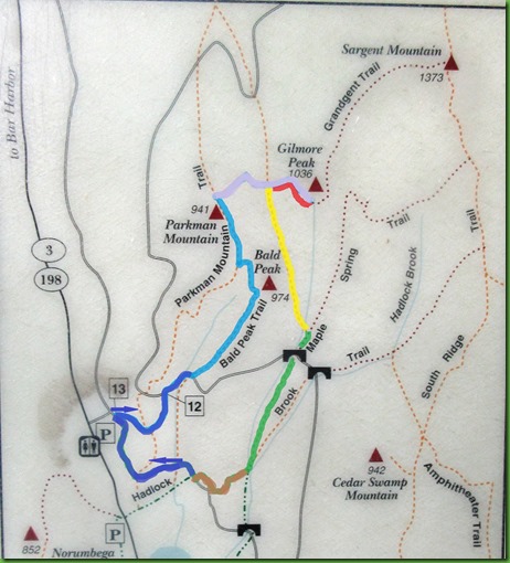
Of course like all hikes in Acadia, there are lots directions to go up to every peak. We’ve chosen take Route 3 to the Parkman Trail Parking lot although we don’t intend to take the Parkman Trail going up. Probably coming back. Our final route is on the map to the left. It’s nothing like what I thought it would be when we start out.
From the parking lot on the carriage road at marker 13 we follow the dark blue arrow up the carriage road to the Bald Peak Trail in Light blue on the map. Of course even the carriage road is up hill.
Looking back at David heading up.

Looking forward at what’s to come, the famous Rockefeller teeth on my right. So funny that using a weed whacker to trim the grass around them is called “flossing” by the volunteers. Love it!

It’s about 10 minutes until 7 when we reach this spot and the sun comes blazing into view.

We head up the first of our trails for today, Bald Mountain Peak Trail.

Of course it’s up too. Actually I really prefer hiking up first and then down when I’m good and tired rather than having the up at the end of the hike.
Sometimes it takes hand and hiking pole to get yourself up there.

First views come into sight.

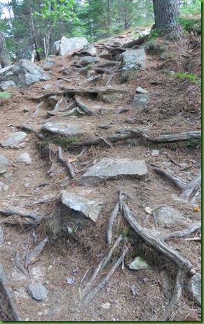
But we still have more rock face and tree roots to get over.

We follow the blue blazes up the rock faces.

Here comes David.

Of course we have to stop for berry picking.

Fantastic views but we still aren’t at the top.

With a strong zoom I can spot Lower Hadlock Pond’s bridge and boat house. So much fun to recognize, from so far away, places we have been. I guess folks up here could have watched us paddle the pond.

But we still have a bit more climbing to do.

And of course more stops for berry picking.

Higher up, same beautiful view behind David.

I didn’t stop as many times as he did so he’s WAY back there when I look this time.

Up ahead, I can see the summit.

And here we are! Peak #1. Bald Mountain.

I wonder if every bald headed man has a picture of himself at the top of Bald Peak.


We head out still on the Bald Mountain Trail (light blue on the map) until it intersects with the Parkman Mountain Trail (dark purple on the map). We’ll take a section of it to Parkman.
But of course you can’t just walk straight over to Parkman Mountain even though you can see it clearly in front of you at what looks like not such a great distance.

You have to go down before you can go back up.

Once down in the bottom between mountains there is a nice stretch of FLAT!

And then it’s back up.

Here we are, Parkman Mountain Summit. Peak #2.
Back down again this time on our way to Gilmore Mountain. We take the Grandgent Trail (light purple on the map). I hadn’t researched it closely enough to understand it was going to be so rocky but we don’t realize at this point that we haven’t seen anything yet.


Rocks or no rocks, I’m a happy happy hiker.

The route is steep and clumsy on our way down to the valley.


Even in the valley is rough going.

We start back up. thank goodness for the blue blazes since the trail is very hard to follow without them.

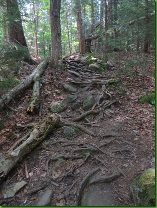
It’s a rooty uphill climb as well.


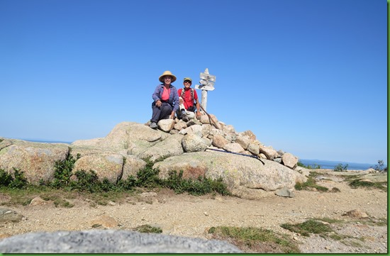
But of course we make it to the top. I’m on the left of the summit in the middle of David’s picture below.

Summit #3 Gilmore Mountain.

We stay a while enjoying the gorgeous views. Water and mountains, what more could you want?

And now to get back to the car.

We have to go back the Transgent Trail (red on the map), rocks and all, to reach the Parkman Trail and take it back to Ruby.

About halfway back to Parkman Trail, we come to a trail marker. What to do? So many choices other than the Transgent Trail.

David sees that he can turn off of the Transgent Trail (red on the map) here and take the Maple Spring Trail (green on the map). That sounds fine doesn’t it? So he’s all for it. Let’s do a trail we haven’t been down and know nothing about. Maple Spring Trail – sounds sweet.

Really great choice I think.


And then things start to change.

Sure doesn’t look like a spring trail, it looks like a rock slide.


And then we discover at another sign post set. AH HA, we should have looked at the map more carefully. Now it’s clear that we’ve been on the Giant Slide Trail (yellow on the map) which LEADS to the Maple Spring Trail.

Pretty sure this is the trail they say you should hike Up rather than down because it’s a Giant Slide DUH – Oh well, here we are . . . . .

Well this was your idea, why are you looking at me?

Turning off onto the Maple Spring Trail (green on the map) doesn’t improve things. In fact, we seem to be hiking mostly in the stream and I wonder how this could possibly be hiked in the spring when the water is up.

Looks like we’re in the bottom doesn’t it? Well no such luck.


I think Hallelujah when I see the Hemlock Carriage Bridge in the distance until I check my map and find that we are not even half way down the Maple Spring Trail.


This picture gives a real sense of the scale of the bridge. I feel pretty small walking under it.


Such a gorgeous structure. Thank you Mr. Rockefeller!

Beyond the bridge the trail becomes more clear and runs along the stream rather than seemingly in it.


We finally leave the Maple Spring Trail (Green on the map) and take the turn onto the Hadlock Brook Trail (Brown on the map). We’re out of the rocks and into the woods.

Then we’re onto the boardwalk through a swampy area.

Just after noon we reach the final leg of our hike, the carriage road (dark blue on the map) which will take us back to Ruby. We’re again going up hill since we changed our route and have come past the level of the parking lot. If we’d hiked back Parkman it would have been shorter and hill all the way. But would it have been as much fun?


What a great day we’ve had on trails we had no clue about. Quite an adventure and rough going in many spots but I’d do it again. FOR SURE!
What a grand hike, and what a day! Beautifully photographed.
ReplyDeleteWow - that was quite an adventure! I really admire you guys!
ReplyDeleteI am with William, that was a grand hike despite the surprises and challenges along the way. And only 4.5 miles to my great surprise. Great variety including views & water, carriage roads & bridges, glacially scraped rocks, peaks and valleys, stream beds & woods. I wouldn't ask for anything more on a Monday. ;)
ReplyDeleteWow- I am worn out just reading about that hike-well done:)
ReplyDeleteAwesome day!! Congratulations on bagging three more peaks! Boy, that was a lot of huge roots. Interesting hike down the spring! We took a different trail down from the Multnomah Falls and it turned out to be a spring and a trail. Thank goodness the spring wasn't running too swiftly but it made for a steep, slippery, rocky trip for awhile. Glad you found some more berries!
ReplyDeleteYep, that was a wonderful hike!!! We love the hikes to those peaks. We actually saw you two on Gilmore Summit from up on Sargent and hikes down to try and catch you. You were gone and headed down the other end of Giant Slide. I believe the high point on Giant Slide is where it intersects with Grandgent Trail. So we all got to do the Giant Slide DOWN!!! We love the scrambling and challenge:o)) It was a glorious day to be on the mountains and SLIDES!!!
ReplyDeleteI bet you're right that all the bald guys have taken their pictures at Bald Mountain :) That picture of the bridge sure does put it into perspective! Nice hike!
ReplyDeleteConquering three summits in one hike and you didn't even look "peaked" in any of the pictures... ;c)
ReplyDeleteI think all of the hiking you did in Maine is more difficult than hiking in the West, except for the elevation. Most of those "trails" look like rock slides! Way to go bagging all those peaks!
ReplyDeleteIt's amazing how many trails are in the park. Seems by now you'd have done them all. Hard to believe how rocky they are. All that was only 4.5miles. Whew.
ReplyDeleteWow, good for you guys, hope you get many more peaks before your time is done.
ReplyDeleteGreat adventure! I love the selfies at the peaks and that I know you so well that I'm sure you were saying something when the camera went off for that first one..lol! Bald man on a bald mountain..love it! Beautiful views and bridge! Only 4.5 miles? Is it true? ;)
ReplyDeleteI can't believe some of that trail and am glad that you thought it was a fun adventure. Definitely the right attitude. That was quite a hike. Thank you for sharing!
ReplyDelete