Tuesday August 15, 2017 Most Recent Posts:
Seawall Campground Moving INTO Acadia National Park
Acadia National Park Norumbega Mountain and Time to Say Goodbye
Mount Desert Island, Maine
Today we set out to hike to our last summit on this side of Acadia. It’s appropriately named Acadia Mountain.
We park in a lot along Route 3. We’re late, it’s almost 7am. Look how many folks are already here but not to worry, there are several hikes that start here. The trail begins across the road.

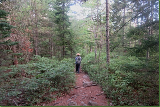
We cross the road and then we do some switching back and forth before we finally arrive at the “real” trail head for the Acadia Mountain Trail. We take the trail to the summit and down coming back the Man O’ War Truck Road.

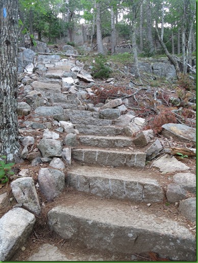
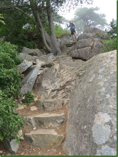
I was told that the Acadia Mountain Trail is one of the original trails created by the “rusticators” in the mid 19th century. Supposedly you can tell these trails because of the granite steps on the trail. Across the road the Acadia Mountain Trail begins with a series of steep granite steps, which is appropriate, seeing how there are so many sections of these scenic staircases throughout the trail.
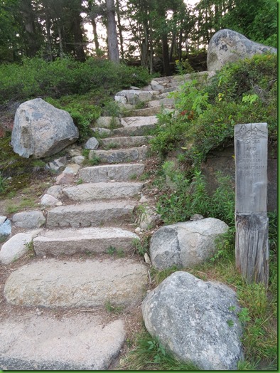
The trail turns left and then there are these granite steps. Not quite as imposing as the first ones.

From there we take the trail to the intersection of the Acadia Mountain Trail and the St. Sauveur Trails. We’ve climbed St. Sauveur earlier this summer. If curious, here’s the post.


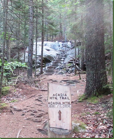
We continue straight ahead and come to THE Acadia Mountain Trail Head.
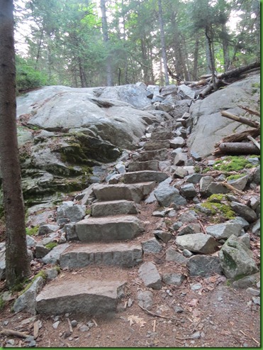
We’re on our way now. Up more granite steps. Even though we’ve done lots of steps in Acadia National Park it always seems odd to be climbing steps up a mountain.
I’m at the bottom.
I’m at the top.

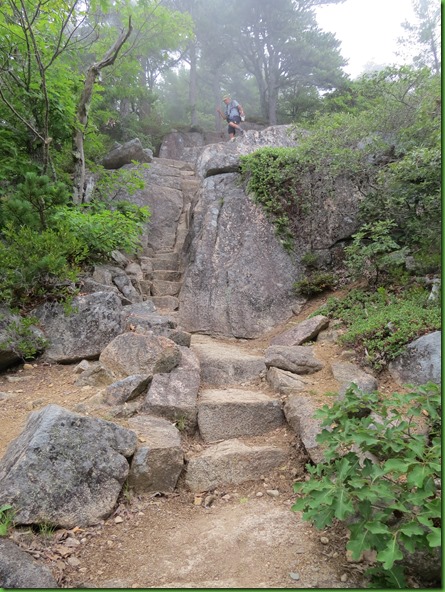
Up the steps, now up the stones. On the way up, there are a few sections of relatively steep rock formations like this that require a bit of scrambling. Even more on the way down.

It’s a long way down. Glad I’m climbing up.

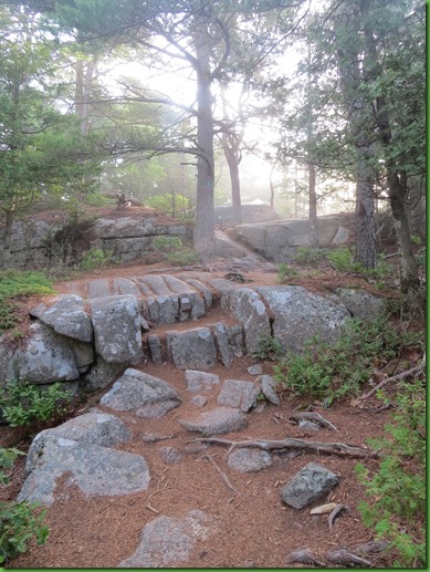
More granite steps.
Here comes David.

Nearing the top we see the fog we were hoping would lift, may not have.

Well this is a serious bummer. Acadia Mountain is raved about for the views. Here are our first ones.

We walk around checking out every direction. Nothing but fog. Things start to lower just a tad and I can see we are looking at Beech Mountain. How do I know? We’ve climbed it and I can see the firetower there on the far left side.

I zoom in, sure enough there it is and not a soul appears to be on it. Guess they weren’t counting on the fog lifting.

We continue on to the summit.

Things are no better here but we take a bad selfie anyway.


We hang around really hoping it will clear up. From here we should be able to see an open view to the south, to Somes Sound and the nearby St. Sauveur Mountain and Flying Mountain. And farther out, in the ocean, Greening Island, and beyond that, the Cranberry Isles. All we see today is fog.

At one point it looks like it might be starting to clear.

But no such luck. It closes back up.

And then even the tips of the mountains are gone. Nothing but clouds, fog.

It feels like it may be coming to cover us up too so we decide it’s probably time to start down while we can still see. No views this morning.

From here it’s pretty much straight down to the Man O’War Brook Truck Road. (see map above)
At this point I had not yet read the description of the trail down as being hand-over-foot climbing in several especially rocky areas on the section of the trail between the summit and the Man O’ War Road. But that’s what we found whether we knew to anticipate it or not. Later I also read on Trip Advisor a discussion in which the trail was rated difficult and probably not for those over say 55 and in good shape. Well that would be us, young and in good shape! HA!
.


The fog comes and goes. One picture shows blue skies the next shows fog in the background. Hmmm I’m thinking here.

When climbing down with short legs, just sit down and hope you can reach something to step on. Known as butt hiking I believe. Works well.

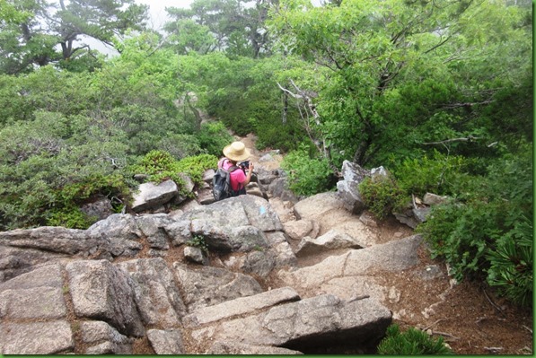
There are some flat stretches between the drops.

David’s looking for the views we are supposed to see on the way down the mountain’s east side. I think the views are just rewards for this , steep and rocky climb down. No views today and no ladders or rungs, as there are on some of the park’s steepest trails.


So wet up here water drops are clinging to the Jack Pine needles.

Ten minutes later he’s looking again. It just makes me laugh out loud. He never gives up. It’s a white out and he’s still at it.

Still smiling as he looks at the upcoming rocks dropping off. I admit, it’s fun.

We both wondered what would happen here if someone stout were to try to come through what looks like a “fat man’s misery” to me.

All righty then! Steps near the bottom but how do you get there? Wonder if we should have come up this way and gone back the other? But then I remember being glad we were climbing up and not down that way too. Oh well . . .
And another challenge. Guess I’ll take a picture before I try it.
From my angle above, the picture doesn’t show the drop off. On the way down, no place to stop for pictures. It looks like I’m going to step right off into the tree tops.

Piece of cake here.
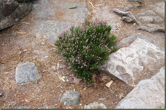
Once down there are some pretty things right at our feet.

Once down we know we must be getting close to the overlook which comes shortly before the turn off onto the Man O’War Brook Truck Road.
When we cross Man O’War Brook we know we’re there.

And sure enough, here is the sign for the cut off to the overlook. Overlook? Really?
Should we bother? Of course – hope springs eternal.

Another set of steps is no surprise. Turns out to be a very good thing. There would be no other way to get down here without possibly sliding right into Somes Sound.

These are the only shots of Somes Sound, the only US Fjard, that we get today on the trail which boasts of fabulous views. The fog is still here.

We couldn’t see the sound from the mountain or the trail but we do see it at nearly water level.

And with a zoom we can see a lobster boat going out.

As we start the climb back up, some nearer at hand beauty catches my eye. The gray skies and water droplets make it more visible. Very nice weaving job SpiderWoman.


Back up top in a short distance we find the trail sign for the Man O’War Truck Road. It also tells us we could go to the Valley Cove Trail but we know that trail is closed.

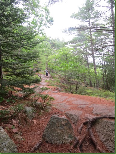
The rest of the hike is a piece of cake.

Just a nice stroll down an old country road.

It’s after 10:30 when we return to the parking lot which we aren’t surprised to see is full. Cars are now lining the Route 102A as well. Glad we came early even with the fog. Maybe it will lift by noon. Who knows. Obviously we have to reschedule this one to repeat on another day. It was great fun and I want to see those promised views.

It’s only about 10:45 when we drive through the darling little town of Southwest Harbor on our way back to Seawall. I just love their library and since it’s on the main street, and we’re driving right by and there is a parking place nearly in front of it, looks like we’re supposed to stop.
I make it a point to visit every library in every town we stay in or near. Sort of like some people do brew pubs. I LOVE libraries!

Just a subtle hint from your friendly librarian.

Like any good New England home, the library has a closed in entryway for heat retention. Not needed today but I’m sure it is in the winter. Libraries are open all year long.
This entryway has bulletin boards on both sides with information about programs both at the library and around the island as well as the password for those who want to sit outside and use the free wifi.
I come in the door into a cozy living room sort of place with people sitting around with laptops and sitting in front of the fire place reading books. I turn back around to get this picture of the entry door. Not sure what it is about this little town but it makes me want to spend a winter here and sit in front of this fireplace with other local folks.

From the front room I walk down a hall with alcoves lined with books on either side of the hallway. In the far distance, you can see the rear door which leads to a parking lot in case you can’t find a parking spot on Main Street.


In the back are the circulation desk, computers you can sign up to use, doors into meeting rooms including the children’s room. and stairs going to the upper floor where there is more cozy seating and more books.

Since we have such a weak signal at Seawall, I’m sure I’ll be back at the library at least once during our short stay but for now, I retrace my steps and go back out through the reading room where the magazines and newspapers are also kept. As I walk back out the front door, I think that empty Eastlake rocker may have my name on it.

But I’m ready for lunch now!
Looks like a challenging hike. It must have been a lot of work building the trail with all those stairs.
ReplyDeleteI also believe in the butt-scoot method and use it frequently. Better to sit down voluntarily than find yourself there by accident!
The CCC did such a amazing job building trails. Wish they were still around:) What a great trail! I love all the rock scrambling to keep up the full body workout. Butt hiking is very popular with me. I feel much better being closer to the ground when heading steeply down. Sorry to see all the fog but it did make for very pretty photos. Beautiful spiderweb:) Glad you at least got to peak at the water down below:) Lovely library! It definitely looks very inviting. Hope you returned to that rocker:)
ReplyDeleteWhat a gorgeous trail you chose for your last hike in the area! And seems like you saved the most challenging one for last. Some of those drop offs were really steep and long -- I'd be resorting to butt hiking, too. It's a very good technique, especially for those of us on the shorter side. :-)) It was beautiful, even without views. I like your hiking schedule and really must reform my ways. It must be wonderful to be finished up early and have the rest of the day ahead to do other things. Eric would be really happy if I took lessons from you. :-))
ReplyDeleteWhat a hike! I find the fog just exposing the summits to be rather magical, actually.
ReplyDeleteButt hiking, I think any one who has hiked has done it at one time or another. Nice foggy hike, sometimes things seem a bit surreal on a foggy hike. Miss my VT library, love the wifi password
ReplyDeleteGlad you enjoyed the hike, even though you didn't get to see the views. We have done hikes like that before but we are still happy to be out hiking. Kevin and I did the Acadia Mountain trail back in July of 2011 and loved it and lucky for us it wasn't foggy so we got to see those beautiful views. Hopefully you can do the hike again some other time.
ReplyDeletewww.travelwithkevinandruth.com
So sorry you missed the views, but you had the fun of granite steps and scrambling the rocks!! We loved this hike. OH, the views are terrific;o))
ReplyDeleteMagical and surreal and I might add mysterious. The fog invites the imagination for the rest of what you cannot see through it, but know is there. I loved the hike with stairs and scrambled, up & down. Real hike that grants a sense of satisfaction that you have actually done something worthy. Loved the library too and could easily spend a day there just browsing or reading in one of those comfy chairs.
ReplyDeleteThat hike looks like it could be tough on the knees and ankles and that is withoutout any slips:) Great views from the top.
ReplyDeleteTough, tough hike! So much fog and so many stairs. I love the selfie. Dad gazing into the fog with hopes of a view is hilarious and so...Dad. I smiled :) He is ever hopeful-that's a endearing quality, I think. That library is so very inviting.
ReplyDeleteWhat a hike! I can't believe that climb down. I wonder how many people are injured trying to get down. Good job doing it safely.
ReplyDeleteNice hike, too bad the views were obstructed. Fog can be nice sometimes :) Libraries can be so comforting, and the smell of paper books is intoxicating. I still remember getting a library card when in grade school, then going into the library truck that came every week to school. That smell of books is still in my head!
ReplyDeleteSo, how many trails do you get out of a pair of pants with all that butt hiking? :cD
ReplyDeleteSome visit brewpubs, you visit libraries, unfortunately I visit bakeries. I'm trying to stop - realizing that it's the fat content of the butter that is flaring up my GERD has actually helped in this regard. Now I have to find something new to search out in every town.
ReplyDelete