Wednesday July 18, 2018 Most Recent Posts:
Great Smoky Mountain National Park Abrams Falls in Cades Cove
Tennessee West Prong and Finding the Walkers

This trail is the shortest way to LeConte Lodge on top of Mt. LeConte. It is the only lodge in the park and only reachable by hiking to it. It has no electricity and is a very popular place requiring reservations well in advance. Thus the parking lot has over night cars as well as day hikers. There are five other ways to get to Le Conte but this is the shortest.
We’re taking the yellow trail up to Alum Cave which on this map is correctly listed as Alum Cave Bluff. More on that later. The trail continues on as a white trail and ends at the top of Mt. Le Conte. Sure wish I’d thought about trying to get reservations. I’d love to do it even at $148 a night meals included. You only live once and I’d love to talk to the people who work there. Do they hike up every day?
Immediately we cross Alum Cave Creek and then follow it for about the first mile over a fairly gentle grade.

Just before reaching the first milestone on this great trail , however, the trail begins following the Styx Branch. This section of trail is tight with rosebay rhododendron, which I imagine offer fabulous blooms during the early summer.

I’m amazed at the big trees along this trail. Surprise number one.


Nancy puts this one in perspective. The trail was closed during the week for two years in 2015 and 16 order for the Trails Forever Program, an arm of Friends of the Smokies, to do major trail restoration. And boy did they. This is an outstanding and very active group without which I just am not sure how the park would manage since they collect no entrance fees. Those of us who hike the trails here are seriously in their debt. Check out their web page. You’ll be amazed.


Along the way, we normally step aside for people coming up behind us in order to have some space between us on a popular trail like this. But we stopped to talk to this hiker and marvel that he was on his way to the lodge on a titanium leg and foot. He said he’d just gotten it and was getting used to the fact that it was a bit heavier than he was used to. I sure do admire him for going right on with the life he wants to live and the things he wants to do.

There are many nice footbridges as we cross back and forth across the waterways. Some are wide with rails on both sides. Some are on log bridges.

I love the water music accompanying our hike and wondered at what looked like the end of a log but turned out to be a rock that somehow the water had carved out. I can only assume that this was done over a very long time during much high water but I thought it was another of the amazing and interesting things I always find on the trails I hike. If you have an explanation for how this happened I’d love to hear it. Nature is just amazing!


The recent renovations show in the wires stabilizing the railing which is not leaning so much as others I’ve walked across

You just never know what you’ll see. Unusual tree decorations.

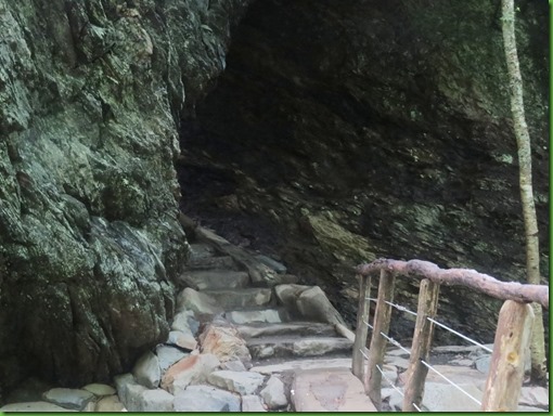
My second surprise comes at almost a mile and a half along the trail. I think this must be Alum Cave. Looks like a Cave doesn’t it?
But actually we’ve reached Arch Rock. It’s pretty incredible. The arch is a large concentration of black slate that was formed by freezing and thawing, which eroded away the softer rock from underneath the harder rock. The trail actually goes under the arch and requires a climb of steps etched into the stone before exiting at the top. Hats off to whoever originally put those steps in. This is one of many times on this trail that I wish I had hiked it before the restoration in order to see the “before”.
The steps continue out the other side of the arch and up to another bridge.
I probably counted the number of steps either coming or going but I don’t remember now.
At the far end of the bridge at the top of Arch Rock is a lovely stand of bright red Fire Pink. Why in the world is it named pink??


Beyond Arch Rock the trail begins ascending towards Alum Cave. We are remember climbing Mt LeConte.
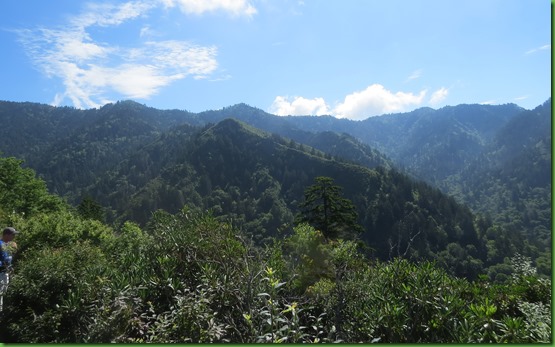
We get our first views out little windows toward Anakeesta Ridge And then we reach what is known as Inspiration Point, a heath bald that offers views of Little Duck Hawk Ridge to the west and Myrtle Point near the top of Mt. LeConte towards the northeast.
Unfortunately for me, the sun was in THE wrong place for getting the waves of mountains without distortion. I really need to find some filters that fit this lens. The ones I had that were supposed to be for this camera never would screw on fully and they kept falling off so eventually they disappeared. Maybe Eric or Laurel can tell me where to get them.
In any case, I like this picture despite its distortion.

These two from further down the trail are sharper but the clouds are threatening to cover up the peaks.


On we go up more erosion protecting steps. I really hope everyone realizes how important it is not to walk beside the steps but rather on them.

Nancy tells us we need to be looking for something known as The Eye of the Needle, a hole in the rock near the top of Little Duck Hawk Ridge. That’s the dark gray ridge in the foreground below.

Eventually I think it was Bill with binoculars who spotted it toward the left end of the rock. Or think that’s it.. Out west they’d call this an arch.

Pretty shortly it’s a white out.

Then it clears enough that Nancy spots another one on the right hand end. So which one is it? Nancy says nobody mentioned two arches in what she read. The more the merrier I say.

Continuing on, the trail drops and Bill, in the lead, looks rather far away

Down and then back up.

Here is definitely one of the problems of not writing your blog posts immediately. I have no idea what Bill is pointing to on that huge rock face which has had a minor landslide. Good spot to stop on the way up what seem like never ending steps.


And then here we are. It’s a HUGE wall of rock and looks like it belongs in the desert southwest. Because it is on the edge of this ridge, you cannot step back far enough away to give any idea of the side of the massive rock face. I’m stunned. This is not what I expected at all.

We head up the stairs to the flat “floor” which is at least 30 or 40 feet up from the trail at the bottom.
On the stairs is a local resident red squirrel who later goes from person to person on the flat above looking for lunch handouts. Clearly he has been successful enough as he’s quite a pest.

Red squirrels are smaller than gray squirrels, larger than chipmunks and live mostly in Northern areas where they feed on the seeds of conifer cones unless they have developed bad habits.


As is clear, Alum Cave really isn't a cave, but is actually a concaved bluff, about 80 feet in height, and roughly 500 feet in length. So technically it should be called Alum Bluff. During the warmer months of the year water drips off from the ledges above. In the winter these droplets turn into large icicles. We did get “dripped” on as we left.
The Epsom Salts Manufacturing Company was established at Alum Cave in 1838 by three farmers from Oconaluftee. Until it was sold in 1854, the company mined alum, magnesium sulfate, saltpeter, magnesia and copperas from the walls. Epsom Salts were used by mountain folk to dye homespun clothing a reddish brown. I’ve read that during the Civil War the Confederate Army began mining saltpeter from the cave, which they used to manufacture gunpowder. The history of the Civil War in this area of Tennessee is very interesting. Tennessee was the last state to suceed from the union but 80% of the folks in Seviere County, mostly subsistance farmers were not in favor. It was a Pro Union area in a Confederate State. If you are interested, here’s the link I found.
Bill and Nancy find a rock ledge and take a load off. No squirrel treats here.

I wander around trying to get a picture that shows both the deeply cut ledge and the mountains. My automatic lens has a very hard time.


Eventually it’s time to head back down the steps. This makes Nancy happy. She likes down.


It’s later in the day, we’re going the opposite direction and the views are slightly different. But still the clouds come in and go out. That’s what they mean by Smoky.


Nancy and I have decided this one that she found is the “real” eye of the needle. It looks different with the blue/white sky behind it than it does from this angle with the green behind it. Harder to find in the zoom lens with the green.

It’s great to get out early since you miss the crowds on most trails, this one being the exception becasue of the early Mount LeConte climbers. But later in the day usually has clearer views. What to do, what to do?

Bill waits for us to catch up while chatting with a group of people who have discovered what Nancy thinks is a Black Rat Snake and I agree. There were actually two of them wound around the leaves in the sun just off the trail. For sure they were not one of the two poisonous snakes in the Smokies, the Northern Copperhead and the Timber Rattlesnake. Both of those have very distinct markings.


Heading back down and through the really fun Arch Rock. Still looks like a cave from here.


Coming out, I can’t see what’s on the other side.

But I’m not surprised that we are joined by dozens of our new best friends.

Alum Creek serenades us for the final distance. It’s been a great hike that I would for sure do again and perhaps even earlier or after the school year has begun though with LeConte Lodge at the top, there may not be a time when there aren’t a lot of people on this trail. It’s worth doing anyway. Thanks again Nancy for doing all the research and Bill for driving. It’s great to have a free day with friends.

.
We hiked to LeConte Lodge in the late 80s. Took the 8 mile Boulevard trail up and came down the Alum Cave trail the next day. My dad was camped with us but didn't hike to the lodge so we had a shuttle. We enjoyed our evening at the lodge, but it rained the entire way back down so we didn't get to see all those great views that you did on your hike. If I remember correctly it cost around $70 per person back then. You would love it!
ReplyDeleteHands down...that was my favorite hike in The Smokies. It had it all. The only things that could possibly make it a better hike would be less people (I'm not a good sharer) and if we could go DOWN in both directions;-)) Yep, I love the DOWN!!! Great photos and wonderful memories...Thanks!!!
ReplyDeleteOnly one thing missing, no waterfall! :-)
DeleteQuite a trail to follow! Beautiful views!
ReplyDeleteThe fellow with the prosthetic was unexpected. It's gotten to the point where prosthetic limbs are on par with the real thing. I read an article recently about a fire fighter who's gone back on the job after losing a leg above the knee. It's a matter of getting used to it.
Another great hike. Nice to have a someone else due the research for a change, I bet:))
ReplyDeleteHow fun to have someone else plan a hike for you! Especially someone you can trust to choose a great hike. :-) That one was a beauty, and I'm sure having such good company made it all the better. As far as a recommendation for a filter, we don't use any. I just avoid shooting into the sun, change my position, or partially block the sun with a tree. And sometimes nothing works. I think I need to research filters, too, haha!
ReplyDeleteWow!! Incredible rock formations. Nice of Nancy to plan that all for you. We saw a glacier in Alaska called LeConte. Hmm, wonder if named for same person.
ReplyDeleteThat was one amazing hike, made even better by going with Nancy and Bill. The trail steps were amazing, think of all the effort that must have been done to make them hiker friendly. Sort of a special "Walk in the Park"! :c)
ReplyDeleteI am totally impressed with the trail work. For anything camera, try B&H Photography online. I really like the shots of the cavern and open area. You just need to pull the shadows out a little. I thought you were going to the lodge?
ReplyDeleteJust looking at all those stairs makes me cringe! Love the pics of Arch Rock - it looks like a magical place. People who maintain these trails are real angels. This one looks especially well done. What a treat to see the snake :-)
ReplyDeleteWhat a fantastic trail! I love all the bridges and those very cool stairs. We will definitely have to check this out if we should return to this area to hike. Very interesting about the Epsom Salts. Thanks for sharing.
ReplyDeleteBeautiful hike, but looks VERY strenuous! I admire your stamina, on those many steps (just think if it had been all rock and no steps…you would definitely need some Epsom Salts, afterwards). And, WOW, the Alum “cave” ledge is massive!
ReplyDeleteFire pink: I agree it’s definitely not pink, but I do see a lot of pink in that red. There’s a color, padparadscha, that I first heard of recently, that is a combination of red, pink and orange (I think the word is literally the name of a type of sapphire, but has now begun to be used more widely for the color itself). Anyway, they are gorgeous!
I love the photo from when you’re on the way down, of the trail with the filigree of exposed tree roots in the moss- very beautiful! And the Tree-hug photo near the beginning — so sweet!
Wow, this is something else. So fantastic. I haven't been to the Smokies since I was in junior high and we didn't really hike because the weather was so bad -- rain constantly. I would love to see this. I, too, like down better than up and those stairs look like a challenge. Still, from your description, I believe it's worth it. Thanks so much!
ReplyDeleteGreat hike and post. So much to see along the way.Nice you could be surprised by it all. A lot of upkeep required. So glad there are folks who care enough to do it.
ReplyDelete