Wednesday PM September 10, 2014
South Rim Campground
Black Canyon of the Gunnison National Park
Montrose, Colorado
After our 6 mile loop hike which took us part way down into the canyon, we want to be right up close to the river. So we drive from the campground back toward the Entrance Station and take the East Portal Road. It provides access into the Curecanti National Recreation Area. The road is closed in winter for good reason.
It is extremely steep (16% grades) with hairpin curves. Vehicles with an overall length (including trailer) greater than 22 feet are prohibited.
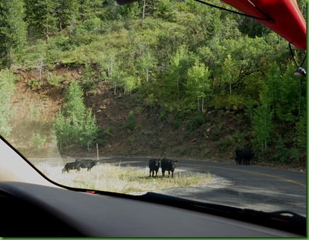
As you can see, there is some private property along the road and a sign says open range. They aren’t kidding. Sure enough, right out the driver’s window about 500 feet beyond the sign. And on and on. Cows are all around the road. With all this “open range” you’d think they wouldn’t want to be up by the road. There aren’t a lot of cars, but we aren’t the only one and apparently motorcycles love this road.
Can’t you just see some motorcycle zipping around one of these curves at excessive mph and finding 5 cows in the middle of the road.
At first we wondered why these snow sticks would be along the edge of the road all the way down but then we realized that it isn’t plowed in the winter and people ski on it. Nice going down but coming back up? Wonder how they do it?
As you can see from the map at the top, the road does not take you down into the canyon within the National Park. So we aren’t going to see the Painted Wall. But we are going down that’s for sure.
The road is right along the edge and the views are beautiful.
When we arrive at the bottom we drive to the end of the road where we meet a dead end at the gate for the Crystal Dam. “Authorized personnel only”. Not being a dam lover, I didn’t care to have a picture of the buildings. We headed back and parked along the road to spend some time with the river.
We find a great kayak put in and look to see where we could go in the direction away from the dam and toward the canyon.
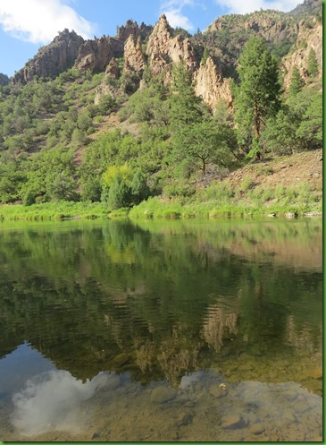
The river looks wonderful and very calm, only a few riffles. I wonder if it ever doesn’t look calm any more.
Further on down the road we come to the first of several fly fishermen we find in the river.
The views and the river are beautiful looking back toward the park.
The picnic spot is just down stream from where the town of East Portal once was. At this point there is a bathhouse with a lot of posted information. Looks like fly fishing is the only thing you are allowed to do here besides picnic.
The information posted on the bath house and that posted on the railings by the picnic area is rather conflicting. No matter, we wouldn’t kayak in possible Class V anyway. If you want to, you’d better go ask the folks who provide the permits. But I wonder when in the world this river is class V. When they let the water loose I suppose.
We drive on down past the town site to the other end of the road where we find not only other fly fishermen but a really fabulous walk in tent campground. I sure would have loved this before Winnona.
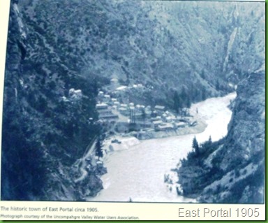
Back at the former site of the town of East Portal, no buildings remain only information signs with pictures
The town perched on these slopes for about 10 years during the building of the Gunnison Tunnel. Because the work was only temporary, most of the town was dismantled as residents and laborers moved on. I suspect it never occurred to anyone that they might be of historic interest.
Plans to divert water from the Black Canyon’s Gunnison River began in 1894 with surveys which eventually revealed locations for both ends of a tunnel (in the canyon and the valley). The intent was a meeting in the middle. .
The tunnel would transfer a portion of the Gunnison River water to the fields of the Uncompahgre Valley to the west. It was a part of The Reclamation Act passed by Theodore Roosevelt. Roosevelt said, “On June 17, 1902, the Reclamation Act was passed...for the purpose of reclaiming the arid West by irrigating lands and thus creating new homes, upon the land...it has gone far to transform the social aspect of the West, making for the stability of the institutions upon which the welfare of the whole country rests...”
And with that, the river was forever changed.
 The Gunnison Tunnel was not the only big project of the Reclamation Act. The act was also responsible for 4 other building projects: 1) Milk River in Montana, 2) Newlands or Truckee, Nevada, 3) North Platte, Wyoming, and 4) the Salt River Project in Arizona. Have you seen any of these rivers?
A road was blasted into the cliffs, and twisted its way down to the river. At grades up to 32% at that time, the road was a nightmare for those who drove supplies, including three 11,600 pound boilers for the power plant, to the emerging town at the canyon bottom.
Once plans were made to construct the Gunnison Tunnel, a town was needed to support the workers and East Port was born. First came tents and log cabins but as digging began in January of 1905 the town quickly grew to 250 people. It provided a dining hall and bunkhouses for single men working round the clock in three shifts. Families lived in private cabins. There was also a hospital, post office, library, general store, school and billiard hall.
The workers labors from 1905 to 1909 drove a tunnel 11 feet x 12 feet six miles through the cliffs of Black Canyon. Digging from both ends they met in the middle in July of 1909. The tunnel is still in use and the gate and equipment houses providing for the workings of the tunnel are all that remains of the town.
Irrigation water generally flows through the tunnel from April to October siphoning off the waters of the Gunnison and preventing it from continuing its natural carving of the canyon. The tunnel supplies 6 primary canals.
There is a great deal more detail on the project here if you are interested.
This is a rather sad ending for me to our days at Black Canyon of the Gunnison National Park. Obviously the tunnel and the dams are not IN the park but they equally obviously have a great effect on it, the river and the beautiful canyon. I wonder how things would have been different if we had tried to blend in rather than take over and subdue.
This canyon is simply fantastic. I just wish I could see a wild river. We’re moving further East tomorrow to see something totally different. See you then.


Beautiful country.
ReplyDeleteKinda hard to think of all the men and equipment and work that went into it.
Yes, the walk in tent campground looks like a place I'd like to camp.I can't imagine driving down (or up) a road with a 32% grade!
ReplyDeleteYou have certainly been treated to some spectacular scenery, and I've really enjoyed the photos and narratives.
What picture perfect postcard shots. The reflection in the river is beautiful.
ReplyDeleteWow, definitely a drive we would love to take. Love the reflections in the water. --Dave
ReplyDeleteThat is a beautiful river.
ReplyDeleteSo glad you got to the river, and got this post out. Hard to imagine digging a tunnel through this kind of rock. Once again, gorgeous country. Those signs make running the river even scarier than the Colorado.
ReplyDeleteJust goes to show that there are no easy choices, a tunnel to divert water for a growing population to farm arid lands, but diminishing some of nature's natural beauty. Glad I didn't have to make that decision.
ReplyDeleteThankfully, Black Canyon still is a wonder to behold. :c)
The bottom line was expansion for mankind. No one thinks about the river or that arid land is part of life's web too. It is sad how much change was forced on the land through laws and the hard work of many man. It still is a beautiful canyon. Thank goodness for the park! Beautiful pictures yet again. Love the reflections in the river!
ReplyDeleteThe environment is so different at the bottom! Wonderful to have the opportunity to experience both. There was so little understanding of the impact of rerouting the water in those days - how different our world would look now if we had learned to feed the masses by cooperation rather than conquering the resources. I believe our grandchildren will find the balance we have upset for the past 3+ centuries. The air pollution in SoCal is significantly less now than it was 40 years ago!
ReplyDeleteAnother wonderful adventure!! I love the reflection photos in the river:) Water just makes for a fun time anywhere.
ReplyDeleteGorgeous countryside, particularly from below like that.
ReplyDelete32% grade, I wouldn't probably want to walk that much less drive it!
ReplyDeleteThanks for telling this important story with the pictures and concern for the environment and the unintended consequences of attempting dominion over Mother Nature. Nicely done!
ReplyDeleteThe reflection photos are just wonderful.
ReplyDelete