Sunday July 16, 2017 Most Recent Posts:
Acadia National Park David Reports on the Seal Cove Auto Museum
Mount Desert Island, Maine A Triple Bag with Nancy and Bill
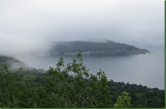
You know the saying “it was a dark and stormy night”? Well around here it’s more like “it was a bright and foggy morning”. This morning it’s socked in but the weather persons promise it will lift by 8am. We are taking them at their word and set out early to hike up Gorham Mountain and around the Cadillac Cliffs. We should have some great views over the water and Thunder Hole.
It’s just been 2 weeks since David got out of the hospital so we’re doing a short hike up the Gorham Mountain Trail with a swing by the Cadillac Cliffs on the way up and then come back down rather than combining it into a multi peak event. We need to see what he can do.
From our location at Narrows Too Campground just off of MDI, we have to drive to every trail or take the bus. BUT the bus doesn’t stop at Narrows Too until 9am and that’s too late for us. Even with the 20 minute or so drive, we are on the trail by 6:45. Not another soul in sight.
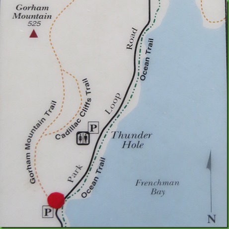
From the map you can see we park at the red dot and hike up the Gorham Mountain Trail, take the side trail around the Cadillac Cliffs on up to Gorham summit with wonderful views ‘we hope’ and then back down Gorham trail to the car.
It’s a rocky wooded trail

A lot of the trails in Acadia were created in the mid 19th Century and this is one of them. I’ve talked previously about the Bates Cairns that mark numerous trails in Acadia. This trail in particular has quite a few Bates Cairns and they seem fairly close together. We notice this in passing and it seems a bit unusual. Then we think we discover why when we get to the 1910 trail memorial to Waldron Bates. Many of the historic trails were dedicated in the early 20th century to the early “rusticators” who came to enjoy the beauty, help create the trails and save the area from development. The Jesup Path that I wrote about earlier was another which has a trail memorial.

From here, it looks like a path leading to a shrine. Bates is quite a revered figure here. One of the top three – Dorr, Eliot and Bates.

What an absolutely lovely and fitting spot to honor one of the literal trail blazers of Acadia.


Further on, another cairn leads me up enough to look back and see David has been side tracked by you know what.

We’re in the bigger rocks when we come to the entrance to the Cadillac Cliffs side trail. You can see it behind me to the right.

Like an entrance door, it leads us into another world

These cliffs were once under the sea.


Along the path I noticed what I thought might be a family reunion but then . .

. . . I thought perhaps it’s just Grandpa telling the kids his stories.

The cliffs section of the trail is quite varied and rugged.

How did they do those steps?


We thought it was interesting that someone had set this little rock on this stump. Looking more closely we like the message. You may have to click the picture to read it.


Tricky footing and a narrow trail at many points along the way.


At one point, there is no way to get across a sheer drop down between ledges so the path makers made a bridge across. Sure hope that log is really secured in place.

On we go around and beneath the Cadillac Cliffs. It’s a rocky landslide type trail in some points.


At this spot there are rungs to help us get up to the next ledge.

David is next. He contemplates the situation with a smile.

Climbing up and up, we finally reach the end of the Cadillac Cliffs Trail and we’re now back on the trail to the Gorham Mountain Summit. Nice of them to put a sign to let us know.

These sorts of steps are a hallmark of the historic trails in Acadia put in prior to and around the turn of the 20th Century.

It’s a long reach to those berries.
We begin to get some views as we are coming out of the woods.
At this point we’ve opened out on the rock face of the south trail headed for the peak. When we look south we can see Otter Cliffs, Otter Point and Western Point beyond them as the fog moves toward them.
A closer look at Otter Point and the cliffs shows the park road running to them. Remember this view, we’ll be down there walking later.
Looking North East toward Great Head and Sand Beach I can see the fog closing in.
It’s only 8am so there’s time for it to clear up before the folks start swarming the beach.
A closer look at Great Head which we previously hiked shows the classic Maine coast. Bet the Florida folks will say it looks like a gator head.


The spots from which we see the lovely views are just as beautiful.

We finally do make it to the top and find the summit sign standing in the usual pile of rocks. But this time they have provided the perfect sitting bench for selfies.

We turn around and head back down the trail. We won’t do the Cadillac Cliffs twice so we can see what the Gorham Mountain Trail looks like on that section. Before leaving the open slopes we find a nice spot overlooking Great Head and Sand Beach for some final open views and a snack. Too early for lunch, it’s only 9:15am. Bench thoughtfully provided by Mother Nature.

Just before we leave, about 9:30am, I zoom in on the now clear Sand Beach and find the folks have already started staking out their spot in the sand. We have seen people in the water but brrrr the ocean temperature rarely exceeds 55 degrees in the summer. And who knew there is approximately one half cup of salt per gallon of ocean water?

Heading back south David is above me when he gets this shot of the trail on the rock face surrounded by trees with Otter Point in the distance.

On the Gorham Mountain section of the trail if you don’t do Cadillac Cliffs, we’re serenaded. I’m glad we didn’t miss this.


Even in our slow and easy style of hiking, by 10:30 we are down at the bottom with all the folks who’ve filled the parking lot since we came. We have a coveted parking space so we decide we’ll get a closer look at some of those views we were seeing from atop Gorham. All we have to do is walk across the loop road from the parking lot and head down the Ocean Path.
The Ocean Path runs right along the rocky coast and directly across from the parking lot is Monument Cove. Looking south that’s Otter Point in the distance. Much closer than we saw it from on top of Gorham. The monument in question is this sea stack. It’s pretty low tide here so the pebble beach is totally exposed.

Time for some rock scrambling. You can nearly walk the shore on the rocks beyond the Ocean Path if you want to. It’s what we usually do if we have the right shoes on and the rocks aren’t wet.

I guess David’s not really scrambling, he’s hiking with his stick. I left mine behind. It’s all hands and feet for me on the rocks.

Many tide pools even this high up because of the height and power of the waves. David seems most interested in this small one.

Okay so what’s in there?

Think I’ll have to ask the ranger about this. Unless you know. They don’t look like crabs or barnacles particularly.

He probably has the perfect view.


The view is equally beautiful looking North toward Great Head and Sand Beach.

Looks like he may have decided to get an even closer view.

From here we walk the Ocean path north to Thunder Hole. We aren’t here at the perfect time which would be high tide but we do get some thunder lite and splash. Lots of our new best friends are here too but then it’s after 10:00 so that’s to be expected.

We join the crowd to get a look at Thunder Hole.

David stakes out a spot at the end looking back at the trough. What they are all looking at is the white water in the lower left of the right picture.


Over eons the relentless force of the ocean gouged a narrow cave in this granite ledge. The cave traps air. When it suddenly fills with air from a powerful incoming wave, it creates a powerful burst of ocean spray and a boom. Well it does that at its best which is about 2 hours before high tide. When the seas are calm and the tide is low all you may here is gurgling. We seem to have shown up somewhere in between. We’re getting spray and noise but not the BIG sprays and BIG booms of a rough surf a couple of hours before high tide. The picture on the left is the water leaving and the one on the right is the surge hitting the cave.


I just barely managed to catch this rainbow across the top of the spray coming out. It almost looks like it is in line with the lichens on the walls of the rocks.


This map shows where we started at the Gorham Mountain Trailhead parking on the far side of the Loop Road. The red line is the park loop road, the white dotted line next to it is the Ocean Path. We headed north to Thunder Hole, turned around and came back to Otter Cliff.
You can see the trail runs right beside and below the loop road on the ocean side in some areas and goes through nicely wooded sections in others. The entire trail is about 4 miles round trip starting at Sand Beach and taking it to the end around Otter Point. It’s wonderful to do in the early morning before the rest of the folks have had their breakfast. BUT it’s tough to find a clear morning that early. Lots of fog affecting your views which are the focus of this trail.


When we reach Otter Cliffs and get out on the rocks, we look back toward Thunder Hole and Sand Beach and find the fog is moving in again over Great Head and them. In and out, in and out, that’s often the way of the fog here.

Apparently one of the experiences to have here these days is rock climbing on the cliffs. These two women have hired an instructor and we watch them as they are packing up to leave. It’s actually hard to see them climbing from here where they are, you have to be at some other point along the rocks with an angle to see the cliffs’ face. There is actually a lot of gear and especially ropes he is organizing.


Time to head back to the car with Great Head almost totallly fogged in. You just never know what the weather is going to do to your plans and your views. But I guarantee, Acadia is beautiful in every kind of weather.

Wild and rugged with great views.
ReplyDeleteGreat views of a beautiful rugged coast.
ReplyDeleteThose views to the south are so wonderful - the weather looks perfect. The rock stairs look very challenging, but that "bridge" under the cliff is definitely a no! You got so many glorious pics, thanks for sharing another great day. Love that the haze is coastal fog and not smoke :-)
ReplyDeleteThe weather certainly does make for so many different views of the same place!!! Love everything about Acadia...It is a very special National Park!!!
ReplyDeleteToday was the eclipse here, and of course the fog didn't burn off until afterwards. Drat. Still lovely in Maine, I see!
ReplyDeleteLike when inversion happens at the canyon, I like these foggy views.
ReplyDeletewhat a gorgeous hike you had. I was hoping someone might ID those things I think maybe they are dead barnacles but I'm probably wrong.
ReplyDeleteThat was another great day! Neat that you caught a rainbow at Thunder Hole! Still don't know who that was in the tide pool. Good question for the rangers.
ReplyDeleteNice rocks and ocean hiking !!!
ReplyDeletemark
What a beautiful landscape!
ReplyDeleteI am always impressed that you get out on the trails so early. Guess we need to go to bed earlier!
ReplyDeleteThat painted rock may have been part of the Kindness Rocks Project, although they are not supposed to leave them in national parks or forests.
Okay, just when I think I don't really care about heading east (because I love the Pacific Northwest so much!) then I read one of your posts. That was a spectacular hike. Every bit of it was gorgeous—the trail, the views, the rocks, the fungi. And the blueberries! That looked like a challenging hike, with all of the climbing. Way to go, David! I think those are barnacles in the photo you were wondering about.
ReplyDeleteBoy do I miss the rocks. This looks like an amazing hike!! I love all the rock steps and scrambling. What beautiful views! You could be on the Oregon coast with the fog, ocean, and rocky cliffs in your photos. You certainly have me thinking very hard about returning to Acadia to do some serious hiking. Thanks for sharing this amazing hike!!
ReplyDeleteNice to see a plaque honoring a person not all scratched up with initials and shot up with bullet holes. I guess people in Maine are better behaved and more respectful. ;c)
ReplyDeleteBeautiful views!! Just what I imagine and expect from Maine. Love the selfie :)
ReplyDelete